Baltimore Bend Conservation Area: hunting and access
Baltimore Bend Conservation Area is 1,168 acres of MDC land in Lafayette County, 3 miles from Waverly. MDC lists deer hunting here (archery and firearms, antlerless permits allowed). Hunters checked 1,684 deer in Lafayette County in 2025.
Data updated October 2026. Area facts: MDC's conservation area data, read 2026-10. Harvest: MDC deer harvest summaries, 2021 to 2025.
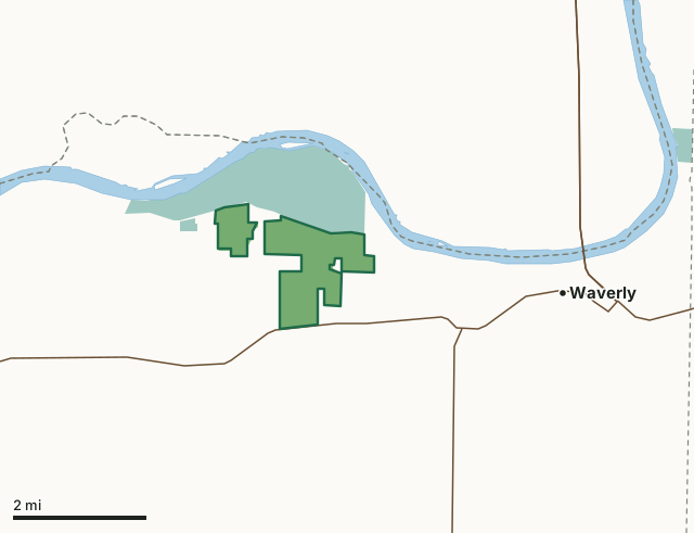
MDC conservation areasNational wildlife refugesBaltimore Bend Conservation AreaCounty lineLakeHighway
| Size | 1,168 acres in 2 pieces |
|---|---|
| County | Lafayette County |
| Deer harvest unit | Lafayette County |
| MDC lists for hunting | Deer, Bear, Turkey, Rabbit, Squirrel, Dove and Quail |
| MDC area number | 8620 |
| MDC region | Kansas City |
| Camping (MDC) | open camping - walk-in/float-in/backpack |
| Nearest towns | Waverly (3 mi), Dover (4 mi) and Norborne (6 mi) |
What is Baltimore Bend Conservation Area like?
Baltimore Bend Conservation Area is situated on the woodland bluffs overlooking the Missouri River between the towns of Dover and Waverly in northeastern Lafayette County. It can be reached via Highway 24, which forms part of the area's southern boundary.
The Lewis and Clark expedition passed present-day Baltimore Bend. Later, the area was the focal point of much of the river's early boat traffic. A river boat named Baltimore sank near an island in the bend of the river and gave rise to the names of Baltimore Island and Baltimore Bend. The Missouri Department of Conservation began acquiring land for Baltimore Bend Conservation Area in 1986. The area presently consists of 1,202 acres. The north half of the area consists of steep, wooded slopes with narrow ridges and drainages that are broad and flat. Most of the open fields are found in the southern portion of the area. About 80 percent of the area is forested. Primary species include oaks, hickory, basswood and black walnut. Native warm-season grasses and grain crops/idle fields provide food and cover for wildlife. The area is managed for a wide variety of game and non-game wildlife....
In MDC's words, from the Baltimore Bend Conservation Area page.
What can you hunt on Baltimore Bend Conservation Area?
MDC's page for Baltimore Bend Conservation Area lists: Deer: archery and firearms, antlerless permits allowed; Bear: archery and firearms; Turkey: archery and firearms; Rabbit; Squirrel; Dove; Quail.
What are the rules on Baltimore Bend Conservation Area?
MDC's standard conservation area rules (Chapter 11 of the Wildlife Code) apply; the area's rules on MDC's site list any it adds.
How many deer are taken around Baltimore Bend Conservation Area?
Baltimore Bend Conservation Area lies in Lafayette County. Hunters checked 1,684 deer in Lafayette County in 2025, against 1,652 in 2024.
| County | Baltimore Bend Conservation Area acres in it | Deer, 2025 | Deer, 2024 | Deer, 2023 |
|---|---|---|---|---|
| Lafayette County | 1,168 | 1,684 | 1,652 | 1,598 |
Harvest for the whole county, not the conservation area alone: MDC deer harvest summaries (2021 to 2025 seasons).
How do you get to Baltimore Bend Conservation Area?
MDC's directions: From Waverly, take Highway 24 west 3 miles.
Nearest towns: Waverly (3 miles), Dover (4 miles), Norborne (6 miles) and Grand Pass (7 miles). Highways within 5 miles: US 24, US 65, MO 23 and MO 10.
What other public land is near Baltimore Bend Conservation Area?
MDC lands within 10 miles:
- Upper Higginsville City Lake (Higginsville): 39 acres, 9.6 miles away
- Malta Bend Community Lake: 24 acres, 9.9 miles away
Public land within 3 miles of Baltimore Bend Conservation Area
Counting Baltimore Bend Conservation Area itself, 2,834 of the 32,764 acres within 3 miles of its boundary are public land open to the public (8.6%), by USGS PAD-US 4.1 and MDC conservation area boundaries.
| Manager | Acres within 3 miles |
|---|---|
| National wildlife refuges | 1,644 |
| MDC conservation areas | 1,190 |
Questions hunters ask
Where is Baltimore Bend Conservation Area?
In Lafayette County, 3 miles from Waverly.
Can you deer hunt on Baltimore Bend Conservation Area?
Yes, by MDC's page: archery and firearms, antlerless permits allowed.
How much public land is around Baltimore Bend Conservation Area?
2,834 acres within 3 miles of its boundary, Baltimore Bend Conservation Area included, by USGS PAD-US 4.1 and MDC conservation area boundaries. The closest other MDC area is Upper Higginsville City Lake (Higginsville) (9.6 miles).
Get a Missouri hunt plan when they open
Hunt plans for Missouri are coming. Join the list and you'll hear first. The first 50 hunters in each new state get their plan free.
Until then, the free FilledTag app for iPhone has a map that works in every state, Missouri included.
Where these facts come from
- Area description, species, rules and directions: MDC, Baltimore Bend Conservation Area; MDC conservation area boundaries.
- Boundary and acres: MDC's map layer above. Surrounding public land: USGS PAD-US 4.1 (fee land open to the public) and MDC conservation area boundaries.
- Deer harvest: MDC deer harvest summaries (2021 to 2025 seasons).
FilledTag is not part of the Missouri Department of Conservation. Check MDC's rules and posted signs before you go.