Belcher Branch Lake Conservation Area: hunting and access
Belcher Branch Lake Conservation Area is 395 acres of MDC land in Buchanan County, 3 miles from Faucett. MDC lists deer hunting here (muzzleloader and archery, archery antlerless permits only). Hunters checked 867 deer in Buchanan County in 2025.
Data updated October 2026. Area facts: MDC's conservation area data, read 2026-10. Harvest: MDC deer harvest summaries, 2021 to 2025.
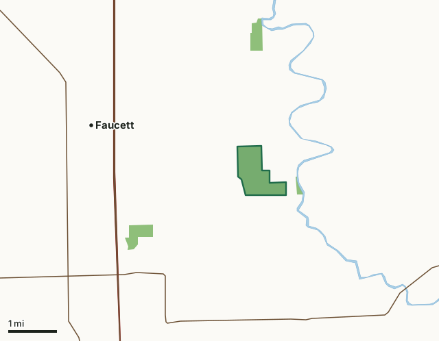
MDC conservation areasBelcher Branch Lake Conservation AreaCounty lineLakeHighway
| Size | 395 acres |
|---|---|
| County | Buchanan County |
| Deer harvest unit | Buchanan County |
| MDC lists for hunting | Deer, Turkey, Rabbit, Squirrel and Quail |
| MDC area number | 8925 |
| MDC region | Northwest |
| Nearest towns | Faucett (3 mi), Dearborn (4 mi) and Agency (4 mi) |
What is Belcher Branch Lake Conservation Area like?
The Conservation Department purchased this area in 1989 and completed construction of Belcher Branch Lake in June 1992.
In addition to the 55-acre Belcher Branch Lake, the area contains cropland, grasslands, and timber. The area surrounding the lake features modestly sloping terrain with well-drained soils, including a thick layer of loess on the upland portions. The Conservation Department manages the forest, fish, and wildlife resources of this area to provide for public recreation and to protect soil and water quality. Farming, mowing, discing, and prescribed burning are used to improve wildlife habitat.
In MDC's words, from the Belcher Branch Lake Conservation Area page.
What can you hunt on Belcher Branch Lake Conservation Area?
MDC's page for Belcher Branch Lake Conservation Area lists: Deer: muzzleloader and archery, archery antlerless permits only; Turkey: archery and firearms; Rabbit; Squirrel; Quail.
What are the rules on Belcher Branch Lake Conservation Area?
MDC's standard conservation area rules (Chapter 11 of the Wildlife Code) apply; the area's rules on MDC's site list any it adds.
How many deer are taken around Belcher Branch Lake Conservation Area?
Belcher Branch Lake Conservation Area lies in Buchanan County. Hunters checked 867 deer in Buchanan County in 2025, against 844 in 2024.
| County | Belcher Branch Lake Conservation Area acres in it | Deer, 2025 | Deer, 2024 | Deer, 2023 |
|---|---|---|---|---|
| Buchanan County | 395 | 867 | 844 | 890 |
Harvest for the whole county, not the conservation area alone: MDC deer harvest summaries (2021 to 2025 seasons).
How do you get to Belcher Branch Lake Conservation Area?
MDC's directions: From St. Joseph, take I-29 south to Faucett (Exit 35), then Route DD east 3 miles, then County Road 330 Road south 0.75 mile to the area entrance.
Nearest towns: Faucett (3 miles), Dearborn (4 miles), Agency (4 miles) and New Market (6 miles). Highways within 5 miles: US 71, I-29, MO 116 and MO 371.
What other public land is near Belcher Branch Lake Conservation Area?
MDC lands within 10 miles:
- Agency Conservation Area: 93 acres, 1.9 miles away
- Bee Creek Conservation Area: 113 acres, 2 miles away
- Anthony and Beatrice Kendzora Conservation Area: 950 acres, 4.5 miles away
- Pigeon Hill Conservation Area: 460 acres, 4.9 miles away
Public land within 3 miles of Belcher Branch Lake Conservation Area
Counting Belcher Branch Lake Conservation Area itself, 620 of the 25,291 acres within 3 miles of its boundary are public land open to the public (2.5%), by USGS PAD-US 4.1 and MDC conservation area boundaries.
| Manager | Acres within 3 miles |
|---|---|
| MDC conservation areas | 620 |
Questions hunters ask
Where is Belcher Branch Lake Conservation Area?
In Buchanan County, 3 miles from Faucett.
Can you deer hunt on Belcher Branch Lake Conservation Area?
Yes, by MDC's page: muzzleloader and archery, archery antlerless permits only.
How much public land is around Belcher Branch Lake Conservation Area?
620 acres within 3 miles of its boundary, Belcher Branch Lake Conservation Area included, by USGS PAD-US 4.1 and MDC conservation area boundaries. The closest other MDC area is Agency Conservation Area (1.9 miles).
Get a Missouri hunt plan when they open
Hunt plans for Missouri are coming. Join the list and you'll hear first. The first 50 hunters in each new state get their plan free.
Until then, the free FilledTag app for iPhone has a map that works in every state, Missouri included.
Where these facts come from
- Area description, species, rules and directions: MDC, Belcher Branch Lake Conservation Area; MDC conservation area boundaries.
- Boundary and acres: MDC's map layer above. Surrounding public land: USGS PAD-US 4.1 (fee land open to the public) and MDC conservation area boundaries.
- Deer harvest: MDC deer harvest summaries (2021 to 2025 seasons).
FilledTag is not part of the Missouri Department of Conservation. Check MDC's rules and posted signs before you go.