Blind Pony Lake Conservation Area: hunting and access
Blind Pony Lake Conservation Area is 2,197 acres of MDC land in Saline County, 4 miles from Mount Leonard. MDC lists deer hunting here (archery only, antlerless permits allowed). Hunters checked 2,048 deer in Saline County in 2025.
Data updated October 2026. Area facts: MDC's conservation area data, read 2026-10. Harvest: MDC deer harvest summaries, 2021 to 2025.
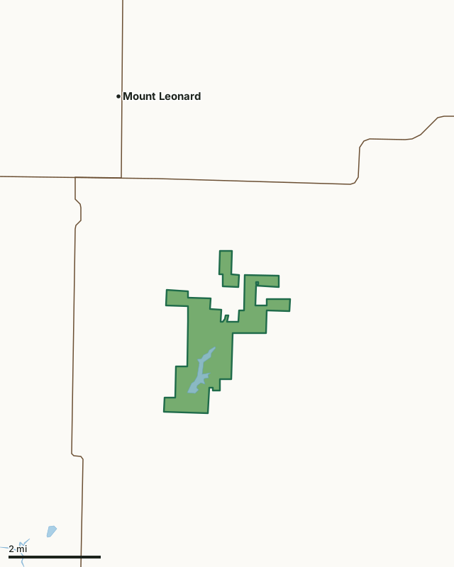
MDC conservation areasBlind Pony Lake Conservation AreaCounty lineLakeHighway
| Size | 2,197 acres in 2 pieces |
|---|---|
| County | Saline County |
| Deer harvest unit | Saline County |
| MDC lists for hunting | Deer, Bear, Turkey, Rabbit, Squirrel, Dove and Quail |
| MDC area number | 6512 |
| MDC region | Central |
| Nearest towns | Mount Leonard (4 mi), Sweet Springs (5 mi) and Blackburn (6 mi) |
What is Blind Pony Lake Conservation Area like?
Blind Pony Lake is situated in the heart of prime agricultural lands between Marshall and Sweet Springs, Missouri. The area primarily serves as a site for a warm-water fish hatchery. It is also a multi-use recreational space that is centered around the 195-acre Blind Pony lake. In 1966, the Blind Pony Lake Conservation Area was established with an initial acquisition of 1,120 acres. Subsequently, 11 additional tracts, totaling 1,127 acres, were acquired to safeguard the lakes watershed and minimize sedimentation. The surrounding uplands are characterized by old fields, croplands, and small woodlots. The fish hatchery offers free tours June - August, every Tuesday at 10 a.m. No registration is required. Just show up at the hatchery office. 16285 BP Hatchery Dr. Sweet Spring, Mo 65351.
Private boats are not allowed on the lake. However, free rental boats are available for use. Electric motors only.
In MDC's words, from the Blind Pony Lake Conservation Area page.
What can you hunt on Blind Pony Lake Conservation Area?
MDC's page for Blind Pony Lake Conservation Area lists: Deer: archery only, antlerless permits allowed; Bear: archery and firearms; Turkey: archery and firearms; Rabbit; Squirrel; Dove; Quail.
What are the rules on Blind Pony Lake Conservation Area?
Closings: Special hours apply on this department area. This area is open to public use only as authorized by posting.
Every conservation area also follows MDC's standard rules in Chapter 11 of the Wildlife Code; the area's full rules are on MDC's site.
How many deer are taken around Blind Pony Lake Conservation Area?
Blind Pony Lake Conservation Area lies in Saline County. Hunters checked 2,048 deer in Saline County in 2025, against 1,954 in 2024.
| County | Blind Pony Lake Conservation Area acres in it | Deer, 2025 | Deer, 2024 | Deer, 2023 |
|---|---|---|---|---|
| Saline County | 2,197 | 2,048 | 1,954 | 2,198 |
Harvest for the whole county, not the conservation area alone: MDC deer harvest summaries (2021 to 2025 seasons).
How do you get to Blind Pony Lake Conservation Area?
MDC's directions: From Sweet Springs at I-70, take Highway 127 north 0.7miles, then Route ZZ east 5.7 miles to the area.
Nearest towns: Mount Leonard (4 miles), Sweet Springs (5 miles), Blackburn (6 miles) and Emma (7 miles). Highways within 5 miles: I-70, US 40, MO 127 and MO 20.
What other public land is near Blind Pony Lake Conservation Area?
MDC lands within 10 miles:
- Blue Lick Conservation Area: 387 acres, 6.3 miles away
- Ralph and Martha Perry Memorial Conservation Area: 4,204 acres, 7 miles away
- Malta Bend Community Lake: 24 acres, 7 miles away
- Marshall Junction Conservation Area: 768 acres, 7.6 miles away
Public land within 3 miles of Blind Pony Lake Conservation Area
Counting Blind Pony Lake Conservation Area itself, 2,197 of the 41,503 acres within 3 miles of its boundary are public land open to the public (5.3%), by USGS PAD-US 4.1 and MDC conservation area boundaries.
| Manager | Acres within 3 miles |
|---|---|
| MDC conservation areas | 2,197 |
Questions hunters ask
Where is Blind Pony Lake Conservation Area?
In Saline County, 4 miles from Mount Leonard.
Can you deer hunt on Blind Pony Lake Conservation Area?
Yes, by MDC's page: archery only, antlerless permits allowed.
How much public land is around Blind Pony Lake Conservation Area?
2,197 acres within 3 miles of its boundary, Blind Pony Lake Conservation Area included, by USGS PAD-US 4.1 and MDC conservation area boundaries. The closest other MDC area is Blue Lick Conservation Area (6.3 miles).
Get a Missouri hunt plan when they open
Hunt plans for Missouri are coming. Join the list and you'll hear first. The first 50 hunters in each new state get their plan free.
Until then, the free FilledTag app for iPhone has a map that works in every state, Missouri included.
Where these facts come from
- Area description, species, rules and directions: MDC, Blind Pony Lake Conservation Area; MDC conservation area boundaries.
- Boundary and acres: MDC's map layer above. Surrounding public land: USGS PAD-US 4.1 (fee land open to the public) and MDC conservation area boundaries.
- Deer harvest: MDC deer harvest summaries (2021 to 2025 seasons).
FilledTag is not part of the Missouri Department of Conservation. Check MDC's rules and posted signs before you go.