Blue Spring Branch Conservation Area: hunting and access
Blue Spring Branch Conservation Area is 555 acres of MDC land in Perry County, next to Lithium. MDC lists deer hunting here (archery and firearms, antlerless permits allowed). Hunters checked 3,160 deer in Perry County in 2025.
Data updated October 2026. Area facts: MDC's conservation area data, read 2026-10. Harvest: MDC deer harvest summaries, 2021 to 2025.
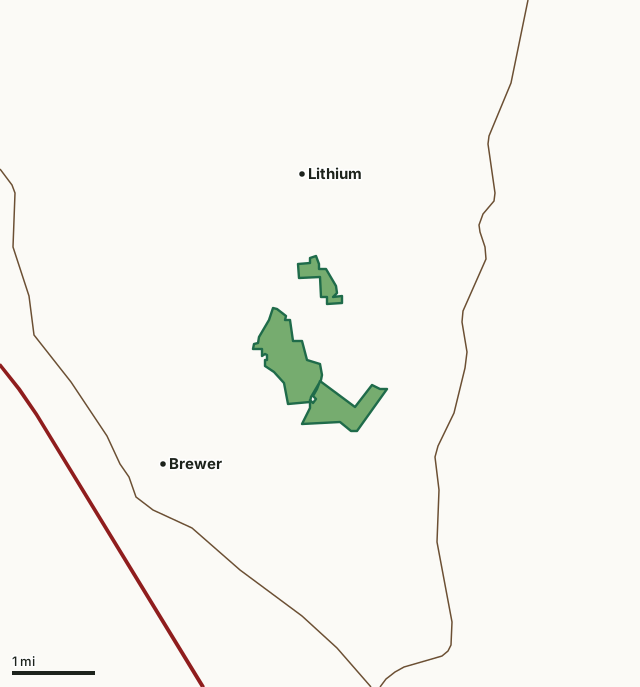
MDC conservation areasBlue Spring Branch Conservation AreaCounty lineHighway
| Size | 555 acres (476 by MDC's page) in 3 pieces |
|---|---|
| County | Perry County |
| Deer harvest unit | Perry County |
| MDC lists for hunting | Deer, Bear, Turkey, Rabbit, Squirrel, Dove and Quail |
| MDC area number | 7918 |
| MDC region | Southeast |
| Nearest towns | Lithium (next to it), Brewer (2 mi) and Perryville (4 mi) |
What is Blue Spring Branch Conservation Area like?
Blue Spring Branch CA is a 551-acre area that consists of open fields and forested tracts that are representative of the Perry County Karst Plains. The Conservation Area is dotted with several sinkholes that are an integral part of Perry County's karst resources. The area features Ball Mill Resurgence Natural Area. The resurgence is fed by many sinkholes in the area, and flows after heavy rains. This is a very good example of the sinkhole topography that is common in this area of Perry County. The forest is a mature mixed oak-hickory forest with a healthy plant diversity.
In MDC's words, from the Blue Spring Branch Conservation Area page.
What can you hunt on Blue Spring Branch Conservation Area?
MDC's page for Blue Spring Branch Conservation Area lists: Deer: archery and firearms, antlerless permits allowed; Bear: archery and firearms; Turkey: archery and firearms; Rabbit; Squirrel; Dove; Quail.
What are the rules on Blue Spring Branch Conservation Area?
Dove Hunting: Use or possession of lead shot is prohibited for hunting doves on this area.
Every conservation area also follows MDC's standard rules in Chapter 11 of the Wildlife Code; the area's full rules are on MDC's site.
How many deer are taken around Blue Spring Branch Conservation Area?
Blue Spring Branch Conservation Area lies in Perry County. Hunters checked 3,160 deer in Perry County in 2025, against 2,791 in 2024.
| County | Blue Spring Branch Conservation Area acres in it | Deer, 2025 | Deer, 2024 | Deer, 2023 |
|---|---|---|---|---|
| Perry County | 555 | 3,160 | 2,791 | 3,366 |
Harvest for the whole county, not the conservation area alone: MDC deer harvest summaries (2021 to 2025 seasons).
How do you get to Blue Spring Branch Conservation Area?
MDC's directions: From Perryville, take Highway 61 north, then Route V north until the pavement ends, and follow County Road 916 into the area.
Nearest towns: Lithium (next to it), Brewer (2 miles), Perryville (4 miles) and St. Mary (5 miles). Highways within 5 miles: I-55, MO 51 and US 61.
What other public land is near Blue Spring Branch Conservation Area?
MDC lands within 10 miles:
- Perry County Community Lake: 311 acres, 4.4 miles away
Public land within 3 miles of Blue Spring Branch Conservation Area
Counting Blue Spring Branch Conservation Area itself, 555 of the 30,016 acres within 3 miles of its boundary are public land open to the public (1.8%), by USGS PAD-US 4.1 and MDC conservation area boundaries.
| Manager | Acres within 3 miles |
|---|---|
| MDC conservation areas | 555 |
Questions hunters ask
Where is Blue Spring Branch Conservation Area?
In Perry County, next to Lithium.
Can you deer hunt on Blue Spring Branch Conservation Area?
Yes, by MDC's page: archery and firearms, antlerless permits allowed.
How much public land is around Blue Spring Branch Conservation Area?
555 acres within 3 miles of its boundary, Blue Spring Branch Conservation Area included, by USGS PAD-US 4.1 and MDC conservation area boundaries. The closest other MDC area is Perry County Community Lake (4.4 miles).
Get a Missouri hunt plan when they open
Hunt plans for Missouri are coming. Join the list and you'll hear first. The first 50 hunters in each new state get their plan free.
Until then, the free FilledTag app for iPhone has a map that works in every state, Missouri included.
Where these facts come from
- Area description, species, rules and directions: MDC, Blue Spring Branch Conservation Area; MDC conservation area boundaries.
- Boundary and acres: MDC's map layer above. Surrounding public land: USGS PAD-US 4.1 (fee land open to the public) and MDC conservation area boundaries.
- Deer harvest: MDC deer harvest summaries (2021 to 2025 seasons).
FilledTag is not part of the Missouri Department of Conservation. Check MDC's rules and posted signs before you go.