Bluff Springs Conservation Area: hunting and access
Bluff Springs Conservation Area is 415 acres of MDC land in Cedar County, 6 miles from Stockton. MDC lists deer hunting here (archery and firearms, antlerless permits allowed). Hunters checked 2,334 deer in Cedar County in 2025.
Data updated October 2026. Area facts: MDC's conservation area data, read 2026-10. Harvest: MDC deer harvest summaries, 2021 to 2025.
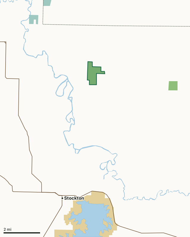
MDC conservation areasFederal land, mostly Corps of Engineers lakesNational wildlife refugesBluff Springs Conservation AreaCounty lineLakeHighway
| Size | 415 acres |
|---|---|
| County | Cedar County |
| Deer harvest unit | Cedar County |
| MDC lists for hunting | Deer, Bear, Turkey and Squirrel |
| MDC area number | 9101 |
| MDC region | Southwest |
| Camping (MDC) | designated camping sites |
| Nearest towns | Stockton (6 mi), Humansville (9 mi) and Collins (9 mi) |
What is Bluff Springs Conservation Area like?
Most of the area is forested but includes a 135-acre restored savanna. The savanna is maintained through periodic prescribed burning. The area is home to numerous wildlife species, including deer, turkey, and squirrel. The native grasses present in the understory of the savanna unit provide important nesting habitat for various ground nesting birds. Primitive camping is available on the south edge of the property in a designated area located just north of the parking lot.
In MDC's words, from the Bluff Springs Conservation Area page.
What can you hunt on Bluff Springs Conservation Area?
MDC's page for Bluff Springs Conservation Area lists: Deer: archery and firearms, antlerless permits allowed; Bear: archery and firearms; Turkey: archery and firearms; Squirrel.
What are the rules on Bluff Springs Conservation Area?
MDC's standard conservation area rules (Chapter 11 of the Wildlife Code) apply; the area's rules on MDC's site list any it adds.
How many deer are taken around Bluff Springs Conservation Area?
Bluff Springs Conservation Area lies in Cedar County. Hunters checked 2,334 deer in Cedar County in 2025, against 2,191 in 2024.
| County | Bluff Springs Conservation Area acres in it | Deer, 2025 | Deer, 2024 | Deer, 2023 |
|---|---|---|---|---|
| Cedar County | 415 | 2,334 | 2,191 | 2,658 |
Harvest for the whole county, not the conservation area alone: MDC deer harvest summaries (2021 to 2025 seasons).
How do you get to Bluff Springs Conservation Area?
MDC's directions: From Stockton, take Route J north 6 miles, then County Road 752 west 0.50 mile, County Road 1701 north 0.25 mile, then County Road 724 west 0.25 mile.
Nearest towns: Stockton (6 miles), Humansville (9 miles), Collins (9 miles) and Umber View Heights (12 miles). Highways within 5 miles: MO 39.
What other public land is near Bluff Springs Conservation Area?
MDC lands within 10 miles:
- Turkey Creek Conservation Area: 158 acres, 3.5 miles away
- Birdsong Conservation Area: 422 acres, 5.1 miles away
- Blackjack Access: 209 acres, 5.1 miles away
- Brush Creek Conservation Area: 149 acres, 6.6 miles away
Public land within 3 miles of Bluff Springs Conservation Area
Counting Bluff Springs Conservation Area itself, 416 of the 25,698 acres within 3 miles of its boundary are public land open to the public (1.6%), by USGS PAD-US 4.1 and MDC conservation area boundaries.
| Manager | Acres within 3 miles |
|---|---|
| MDC conservation areas | 415 |
| Federal land, mostly Corps of Engineers lakes | 1 |
Questions hunters ask
Where is Bluff Springs Conservation Area?
In Cedar County, 6 miles from Stockton.
Can you deer hunt on Bluff Springs Conservation Area?
Yes, by MDC's page: archery and firearms, antlerless permits allowed.
How much public land is around Bluff Springs Conservation Area?
416 acres within 3 miles of its boundary, Bluff Springs Conservation Area included, by USGS PAD-US 4.1 and MDC conservation area boundaries. The closest other MDC area is Turkey Creek Conservation Area (3.5 miles).
Get a Missouri hunt plan when they open
Hunt plans for Missouri are coming. Join the list and you'll hear first. The first 50 hunters in each new state get their plan free.
Until then, the free FilledTag app for iPhone has a map that works in every state, Missouri included.
Where these facts come from
- Area description, species, rules and directions: MDC, Bluff Springs Conservation Area; MDC conservation area boundaries.
- Boundary and acres: MDC's map layer above. Surrounding public land: USGS PAD-US 4.1 (fee land open to the public) and MDC conservation area boundaries.
- Deer harvest: MDC deer harvest summaries (2021 to 2025 seasons).
FilledTag is not part of the Missouri Department of Conservation. Check MDC's rules and posted signs before you go.