Bois D'Arc Conservation Area: hunting and access
Bois D'Arc Conservation Area is 3,210 acres of MDC land in Greene County, 3 miles from Ash Grove. MDC lists deer hunting here (archery only, antlerless permits allowed). Hunters checked 2,955 deer in Greene County in 2025.
Data updated October 2026. Area facts: MDC's conservation area data, read 2026-10. Harvest: MDC deer harvest summaries, 2021 to 2025.
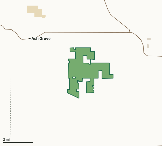
MDC conservation areasState parks and historic sitesCounty, city and regional landBois D'Arc Conservation AreaCounty lineHighway
| Size | 3,210 acres |
|---|---|
| County | Greene County |
| Deer harvest unit | Greene County |
| MDC lists for hunting | Deer, Bear, Turkey, Rabbit, Squirrel, Dove and Quail |
| MDC area number | 8517 |
| MDC region | Southwest |
| Nearest towns | Ash Grove (3 mi), Willard (3 mi) and Halltown (7 mi) |
What is Bois D'Arc Conservation Area like?
Bois D'Arc (pronounced Bo-dark) Conservation Area is located in Greene County, one mile north of the town of Bois D'Arc. This conservation area was named after the trees that dominate the mostly open landscape of the region. The Osage Indians used the sturdy limbs of these trees to make their bows. Thus the name Bois D'Arc, meaning arc of wood. Other local names for these trees are hedge apple, Bois D'Arc tree, bow-wood, and hedge. Some of the trees on this area are more than 100 years old.
Bois D'Arc Conservation Area is managed primarily for bobwhite quail, doves, and cottontail rabbits. Local farmers share-crop the area under contracts that also benefit the local economy. The contour strip-cropping practices reduce soil erosion and provide the habitat diversity attractive to wildlife species, such as quail, rabbit, marsh hawk, dove, and many songbirds. Several small, fishless ponds serve as breeding areas for aquatic turtles and salamanders. Some lowland sites are attractive to woodcock and wetland wildlife species. A small deer herd and a few wild turkeys can be found on the area. Please note that firearms that fire a single projectile are prohibited. This conservation area was acquired in part through the Pittman-Robertson Wildlife Restoration Act administered by the U.S. Fish and Wildlife Service. The Andy Dalton Shooting Range and Outdoor Education Center is also...
In MDC's words, from the Bois D'Arc Conservation Area page.
What can you hunt on Bois D'Arc Conservation Area?
MDC's page for Bois D'Arc Conservation Area lists: Deer: archery only, antlerless permits allowed; Bear: archery only; Turkey: archery and firearms; Rabbit; Squirrel; Dove; Quail.
What are the rules on Bois D'Arc Conservation Area?
Closings: Special hours apply on this department area. This area is open to public use only as authorized by posting.
Target Shooting and Shooting Ranges: A staffed shooting range is located on this department area. Target shooting is not allowed anywhere on this area except for designated shooting range(s). Shooting range(s) on this area are open to public use only as authorized by posting. Ranges may be opened or closed at any time for maintenance or department sponsored events or programs. Range use fees apply on this department area. Possession of alcoholic beverages is prohibited on all ranges and associated parking lots. Groups of more than 10 people must obtain a special use permit prior to using the range. To obtain a special use...
Field Trials: Field trials are allowed on this department area only by special use permit. To obtain a special use permit, contact the area manager at the phone number listed for this area in the area details section.
Dove Hunting: Use or possession of lead shot is prohibited for hunting doves on this area.
Every conservation area also follows MDC's standard rules in Chapter 11 of the Wildlife Code; the area's full rules are on MDC's site.
How many deer are taken around Bois D'Arc Conservation Area?
Bois D'Arc Conservation Area lies in Greene County. Hunters checked 2,955 deer in Greene County in 2025, against 2,813 in 2024.
| County | Bois D'Arc Conservation Area acres in it | Deer, 2025 | Deer, 2024 | Deer, 2023 |
|---|---|---|---|---|
| Greene County | 3,210 | 2,955 | 2,813 | 3,386 |
Harvest for the whole county, not the conservation area alone: MDC deer harvest summaries (2021 to 2025 seasons).
How do you get to Bois D'Arc Conservation Area?
MDC's directions: From Springfield I-44 and Highway 160 interchange (Exit 75), take Highway 160 west about 12 miles to Farm Road 61. Turn south 2.50 miles to the Andy Dalton Shooting Range entrance.
Nearest towns: Ash Grove (3 miles), Willard (3 miles), Halltown (7 miles) and Walnut Grove (7 miles). Highways within 5 miles: US 160, MO 266 and MO 123.
What other public land is near Bois D'Arc Conservation Area?
MDC lands within 10 miles:
- Phenix Access: 149 acres, 3.9 miles away
- Rocky Barrens Conservation Area: 275 acres, 4.5 miles away
- Little Sac Woods Conservation Area: 772 acres, 7.4 miles away
- Paris Springs Access: 210 acres, 9.6 miles away
- Dale Sare Conservation Area: 316 acres, 9.7 miles away
Public land within 3 miles of Bois D'Arc Conservation Area
Counting Bois D'Arc Conservation Area itself, 3,295 of the 43,066 acres within 3 miles of its boundary are public land open to the public (7.7%), by USGS PAD-US 4.1 and MDC conservation area boundaries.
| Manager | Acres within 3 miles |
|---|---|
| MDC conservation areas | 3,211 |
| State parks and historic sites | 61 |
| County, city and regional land | 23 |
Questions hunters ask
Where is Bois D'Arc Conservation Area?
In Greene County, 3 miles from Ash Grove.
Can you deer hunt on Bois D'Arc Conservation Area?
Yes, by MDC's page: archery only, antlerless permits allowed.
How much public land is around Bois D'Arc Conservation Area?
3,295 acres within 3 miles of its boundary, Bois D'Arc Conservation Area included, by USGS PAD-US 4.1 and MDC conservation area boundaries. The closest other MDC area is Phenix Access (3.9 miles).
Get a Missouri hunt plan when they open
Hunt plans for Missouri are coming. Join the list and you'll hear first. The first 50 hunters in each new state get their plan free.
Until then, the free FilledTag app for iPhone has a map that works in every state, Missouri included.
Where these facts come from
- Area description, species, rules and directions: MDC, Bois D'Arc Conservation Area; MDC conservation area boundaries.
- Boundary and acres: MDC's map layer above. Surrounding public land: USGS PAD-US 4.1 (fee land open to the public) and MDC conservation area boundaries.
- Deer harvest: MDC deer harvest summaries (2021 to 2025 seasons).
FilledTag is not part of the Missouri Department of Conservation. Check MDC's rules and posted signs before you go.