Bull Shoals Lake Management Lands: hunting and access
Bull Shoals Lake Management Lands is 35,896 acres of MDC land in Taney and Ozark counties, next to Pontiac. MDC lists deer hunting here (archery and firearms, antlerless permits allowed). Hunters checked 2,452 deer in Taney County in 2025.
Data updated October 2026. Area facts: MDC's conservation area data, read 2026-10. Harvest: MDC deer harvest summaries, 2021 to 2025.
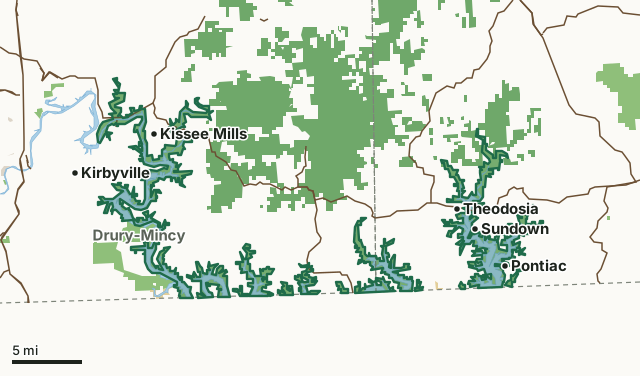
MDC conservation areasNational forestFederal land, mostly Corps of Engineers lakesCounty, city and regional landBull Shoals Lake Management LandsCounty lineLakeHighway
| Size | 35,896 acres in 14 pieces |
|---|---|
| Counties | Taney County and Ozark County |
| Deer harvest unit | Taney County, Ozark County |
| MDC lists for hunting | Deer, Bear, Turkey, Rabbit, Squirrel, Dove and Quail |
| MDC area number | 6325 |
| MDC region | Ozark |
| Nearest towns | Pontiac (next to it), Sundown (next to it) and Theodosia (next to it) |
What is Bull Shoals Lake Management Lands like?
Through a habitat management agreement between the Missouri Department of Conservation (MDC) and the US Army Corps of Engineers (COE), the land surrounding the Bull Shoals Lake offers a vast opportunity for nature viewing, hiking, hunting, fishing, and recreational use. There are several access points along the lake and its tributaries, some are maintained by MDC, some by the COE , and some are not maintained but still provide public access to the managed lands around the lake. The lake provides hydroelectric power generation, and provides flood control for the White River below the dam, as well as for Taneycomo, Table Rock, and Beaver Lakes upstream. The lake is subject to fluctuating water levels and often times covers area roads and parking areas.
In MDC's words, from the Bull Shoals Lake Management Lands page.
What can you hunt on Bull Shoals Lake Management Lands?
MDC's page for Bull Shoals Lake Management Lands lists: Deer: archery and firearms, antlerless permits allowed; Bear: archery and firearms; Turkey: archery and firearms; Rabbit; Squirrel; Dove; Quail.
What are the rules on Bull Shoals Lake Management Lands?
MDC's standard conservation area rules (Chapter 11 of the Wildlife Code) apply; the area's rules on MDC's site list any it adds.
How many deer are taken around Bull Shoals Lake Management Lands?
Bull Shoals Lake Management Lands lies in 2 counties. Hunters checked 2,452 deer in Taney County in 2025, against 2,057 in 2024.
| County | Bull Shoals Lake Management Lands acres in it | Deer, 2025 | Deer, 2024 | Deer, 2023 |
|---|---|---|---|---|
| Taney County | 21,269 | 2,452 | 2,057 | 2,805 |
| Ozark County | 14,582 | 2,819 | 2,633 | 3,257 |
Harvest for the whole county, not the conservation area alone: MDC deer harvest summaries (2021 to 2025 seasons).
How do you get to Bull Shoals Lake Management Lands?
MDC's directions: Bull Shoals Lake ML spreads across southwest Ozark County, eastern Taney County and northern Arkansas. Several county and state roads provide access to the lake. Please see area map for details.
Nearest towns: Pontiac (next to it), Sundown (next to it), Theodosia (next to it) and Kissee Mills (next to it). Highways within 5 miles: US 160, MO 95, MO 125, MO 76 and MO 5.
What other public land is near Bull Shoals Lake Management Lands?
MDC lands within 10 miles:
- Drury-Mincy Conservation Area: 6,161 acres, next to it
- The Lewis Family, Dean, Anna Mae and David D. Lewis Memorial Conservation Area: 356 acres, 3.4 miles away
- Boston Ferry Conservation Area: 170 acres, 4.2 miles away
Public land within 3 miles of Bull Shoals Lake Management Lands
Counting Bull Shoals Lake Management Lands itself, 65,476 of the 338,111 acres within 3 miles of its boundary are public land open to the public (19.4%), by USGS PAD-US 4.1 and MDC conservation area boundaries.
| Manager | Acres within 3 miles |
|---|---|
| MDC conservation areas | 42,283 |
| National forest | 22,165 |
| Federal land, mostly Corps of Engineers lakes | 1,028 |
Questions hunters ask
Where is Bull Shoals Lake Management Lands?
In Taney and Ozark counties, next to Pontiac.
Can you deer hunt on Bull Shoals Lake Management Lands?
Yes, by MDC's page: archery and firearms, antlerless permits allowed.
How much public land is around Bull Shoals Lake Management Lands?
65,476 acres within 3 miles of its boundary, Bull Shoals Lake Management Lands included, by USGS PAD-US 4.1 and MDC conservation area boundaries. The closest other MDC area is Drury-Mincy Conservation Area (next to it).
Get a Missouri hunt plan when they open
Hunt plans for Missouri are coming. Join the list and you'll hear first. The first 50 hunters in each new state get their plan free.
Until then, the free FilledTag app for iPhone has a map that works in every state, Missouri included.
Where these facts come from
- Area description, species, rules and directions: MDC, Bull Shoals Lake Management Lands; MDC conservation area boundaries.
- Boundary and acres: MDC's map layer above. Surrounding public land: USGS PAD-US 4.1 (fee land open to the public) and MDC conservation area boundaries.
- Deer harvest: MDC deer harvest summaries (2021 to 2025 seasons).
FilledTag is not part of the Missouri Department of Conservation. Check MDC's rules and posted signs before you go.