Cedar Gap Conservation Area: hunting and access
Cedar Gap Conservation Area is 436 acres of MDC land in Wright County, 5 miles from Mansfield. MDC lists deer hunting here (archery and firearms, antlerless permits allowed). Hunters checked 3,625 deer in Wright County in 2025.
Data updated October 2026. Area facts: MDC's conservation area data, read 2026-10. Harvest: MDC deer harvest summaries, 2021 to 2025.
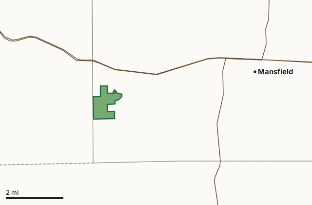
MDC conservation areasCedar Gap Conservation AreaCounty lineHighway
| Size | 436 acres |
|---|---|
| County | Wright County |
| Deer harvest unit | Wright County |
| MDC lists for hunting | Deer, Bear, Turkey and Squirrel |
| MDC area number | 9908 |
| MDC region | Ozark |
| Nearest towns | Mansfield (5 mi), Seymour (6 mi) and Ava (9 mi) |
What is Cedar Gap Conservation Area like?
Cedar Gap CA came into existence in 1999 thanks in large part to the dedication and commitment of a small group of private citizens from Springfield and the local community of Cedar Gap.
The Cedar Gap Plateau is recognized as the second highest point in the State of Missouri. From this large plateau, three large watersheds begin: Gasconade River, Finley River, and Bryant Creek. At Cedar Gap CA, visitors can explore the headwaters of Bryant Creek, view limestone glades, and explore the oak/hickory forest. A gravel-surfaced trail leads from the parking lot to a valley overlook. This three-eighths mile trail can accommodate most hikers with some effort. For a more rugged hike, visitors can continue beyond the overlook and hike the 1.6 mile loop trail. While hiking or exploring, visitors will notice the remnants of a limestone quarry and limestone glades. Management practices on the glades are conducted periodically to stimulate native plants and flowers, and to improve wildlife habitat. During most of the year, Bryant Creek is a peaceful bubbling brook. In periods of heavy...
In MDC's words, from the Cedar Gap Conservation Area page.
What can you hunt on Cedar Gap Conservation Area?
MDC's page for Cedar Gap Conservation Area lists: Deer: archery and firearms, antlerless permits allowed; Bear: archery and firearms; Turkey: archery and firearms; Squirrel.
What are the rules on Cedar Gap Conservation Area?
MDC's standard conservation area rules (Chapter 11 of the Wildlife Code) apply; the area's rules on MDC's site list any it adds.
How many deer are taken around Cedar Gap Conservation Area?
Cedar Gap Conservation Area lies in Wright County. Hunters checked 3,625 deer in Wright County in 2025, against 3,079 in 2024.
| County | Cedar Gap Conservation Area acres in it | Deer, 2025 | Deer, 2024 | Deer, 2023 |
|---|---|---|---|---|
| Wright County | 436 | 3,625 | 3,079 | 3,926 |
Harvest for the whole county, not the conservation area alone: MDC deer harvest summaries (2021 to 2025 seasons).
How do you get to Cedar Gap Conservation Area?
MDC's directions: From Mansfield, take Highway 60 west 4 miles, then Route O south 0.75 mile to the end of the pavement, continue on gravel road 0.25 mile to parking lot.
Nearest towns: Mansfield (5 miles), Seymour (6 miles), Ava (9 miles) and Diggins (10 miles). Highways within 5 miles: US 60 and MO 5.
What other public land is near Cedar Gap Conservation Area?
Public land within 3 miles of Cedar Gap Conservation Area
Counting Cedar Gap Conservation Area itself, 436 of the 25,691 acres within 3 miles of its boundary are public land open to the public (1.7%), by USGS PAD-US 4.1 and MDC conservation area boundaries.
| Manager | Acres within 3 miles |
|---|---|
| MDC conservation areas | 436 |
Questions hunters ask
Where is Cedar Gap Conservation Area?
In Wright County, 5 miles from Mansfield.
Can you deer hunt on Cedar Gap Conservation Area?
Yes, by MDC's page: archery and firearms, antlerless permits allowed.
How much public land is around Cedar Gap Conservation Area?
436 acres within 3 miles of its boundary, Cedar Gap Conservation Area included, by USGS PAD-US 4.1 and MDC conservation area boundaries.
Get a Missouri hunt plan when they open
Hunt plans for Missouri are coming. Join the list and you'll hear first. The first 50 hunters in each new state get their plan free.
Until then, the free FilledTag app for iPhone has a map that works in every state, Missouri included.
Where these facts come from
- Area description, species, rules and directions: MDC, Cedar Gap Conservation Area; MDC conservation area boundaries.
- Boundary and acres: MDC's map layer above. Surrounding public land: USGS PAD-US 4.1 (fee land open to the public) and MDC conservation area boundaries.
- Deer harvest: MDC deer harvest summaries (2021 to 2025 seasons).
FilledTag is not part of the Missouri Department of Conservation. Check MDC's rules and posted signs before you go.