Clark Conservation Area: hunting and access
Clark Conservation Area is 621 acres of MDC land in Clark County, 6 miles from Wyaconda. MDC lists deer hunting here (archery and firearms, antlerless permits allowed). Hunters checked 2,750 deer in Clark County in 2025.
Data updated October 2026. Area facts: MDC's conservation area data, read 2026-10. Harvest: MDC deer harvest summaries, 2021 to 2025.
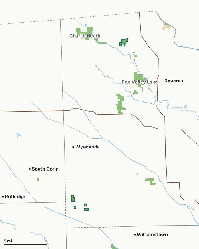
MDC conservation areasState parks and historic sitesClark Conservation AreaCounty lineLakeHighway
| Size | 621 acres in 5 pieces |
|---|---|
| County | Clark County |
| Deer harvest unit | Clark County |
| MDC lists for hunting | Deer, Turkey and Squirrel |
| MDC area number | 8147 |
| MDC region | Northeast |
| Camping (MDC) | walk-in, float-in or backpack camping (not during deer and turkey seasons) and designated camping sites |
| Nearest towns | Wyaconda (6 mi), South Gorin (6 mi) and Williamstown (6 mi) |
What is Clark Conservation Area like?
Clark Conservation Areas original warranty deed is dated 1978. The purchase was lengthy and complicated because the property was scattered across Clark County in 12 parcels of land. The seller was Consolidated Packaging Corporation, previously known as Crandon Paper Mill or Company (and in some writings was referred to as Crandon Tree or Forest Farm). The original purchase was 2,717.46 acres. The final purchase from Consolidated Packaging Corporation was made in 1981, which added another 98.5 acres to the total purchase. Portions of these acquisitions became parts of Fox Valley and Charlie Heath Memorial Conservation Areas. The two isolated tracts located between county roads 57 and 61 were exchanged for a tract adjacent to Neeper CA in 2022. Today, Clark CA totals about 648 acres in six tracts. Early management by Consolidated Packaging Corporation of these parcels was for the production of pulp and paper to construct boxes. The company had enrolled these lands into the Forest Cropland System that was administered by the Department. This program was established to help prevent land use conversion of forestland by providing tax benefits to forestland owners who maintained their woodlands to certain specifications. Clark CA is mostly covered by timber. There were small portions of a few tracts that were still open in the mid-1960s, but these also have converted to timber. The paper company created plantations of trees, some of which were stands of cottonwoods and pines and are still evident. In the mid-1970s, a lake was built on private land damming Bear Creek. This lake inundates the portion of Clark CA known as the Bear Creek Lake Tract. The Department does not own the entire lake, as it is shared with three other landowners.
In MDC's words, from the Clark Conservation Area page.
What can you hunt on Clark Conservation Area?
MDC's page for Clark Conservation Area lists: Deer: archery and firearms, antlerless permits allowed; Turkey: archery and firearms; Squirrel.
What are the rules on Clark Conservation Area?
MDC's standard conservation area rules (Chapter 11 of the Wildlife Code) apply; the area's rules on MDC's site list any it adds.
How many deer are taken around Clark Conservation Area?
Clark Conservation Area lies in Clark County. Hunters checked 2,750 deer in Clark County in 2025, against 2,750 in 2024.
| County | Clark Conservation Area acres in it | Deer, 2025 | Deer, 2024 | Deer, 2023 |
|---|---|---|---|---|
| Clark County | 621 | 2,750 | 2,750 | 2,707 |
Harvest for the whole county, not the conservation area alone: MDC deer harvest summaries (2021 to 2025 seasons).
How do you get to Clark Conservation Area?
MDC's directions: The Nixon Branch Tract is nine miles north of Kahoka on Highway 81, then 2.50 miles west on gravel road 26. The Bear Creek Tract is 3.50 miles south of Wyaconda on Route A, then 1.75 miles south on gravel road 230.
Nearest towns: Wyaconda (6 miles), South Gorin (6 miles), Williamstown (6 miles) and Revere (8 miles). Highways within 5 miles: MO 81.
What other public land is near Clark Conservation Area?
MDC lands within 10 miles:
- Charlie Heath Memorial Conservation Area: 1,651 acres, 1.5 miles away
- Fox Valley Lake Conservation Area: 2,144 acres, 3.2 miles away
- Ella Ewing Lake Conservation Area: 61 acres, 4.1 miles away
- Deer Ridge Conservation Area: 7,293 acres, 4.7 miles away
- Neeper Conservation Area: 323 acres, 7.3 miles away
Public land within 3 miles of Clark Conservation Area
Counting Clark Conservation Area itself, 1,040 of the 55,917 acres within 3 miles of its boundary are public land open to the public (1.9%), by USGS PAD-US 4.1 and MDC conservation area boundaries.
| Manager | Acres within 3 miles |
|---|---|
| MDC conservation areas | 1,040 |
Questions hunters ask
Where is Clark Conservation Area?
In Clark County, 6 miles from Wyaconda.
Can you deer hunt on Clark Conservation Area?
Yes, by MDC's page: archery and firearms, antlerless permits allowed.
How much public land is around Clark Conservation Area?
1,040 acres within 3 miles of its boundary, Clark Conservation Area included, by USGS PAD-US 4.1 and MDC conservation area boundaries. The closest other MDC area is Charlie Heath Memorial Conservation Area (1.5 miles).
Get a Missouri hunt plan when they open
Hunt plans for Missouri are coming. Join the list and you'll hear first. The first 50 hunters in each new state get their plan free.
Until then, the free FilledTag app for iPhone has a map that works in every state, Missouri included.
Where these facts come from
- Area description, species, rules and directions: MDC, Clark Conservation Area; MDC conservation area boundaries.
- Boundary and acres: MDC's map layer above. Surrounding public land: USGS PAD-US 4.1 (fee land open to the public) and MDC conservation area boundaries.
- Deer harvest: MDC deer harvest summaries (2021 to 2025 seasons).
FilledTag is not part of the Missouri Department of Conservation. Check MDC's rules and posted signs before you go.