Cooper Hill Conservation Area: hunting and access
Cooper Hill Conservation Area is 219 acres of MDC land in Osage County, 9 miles from Bland. MDC lists deer hunting here (muzzleloader and archery, antlerless permits allowed). Hunters checked 3,740 deer in Osage County in 2025.
Data updated October 2026. Area facts: MDC's conservation area data, read 2026-10. Harvest: MDC deer harvest summaries, 2021 to 2025.
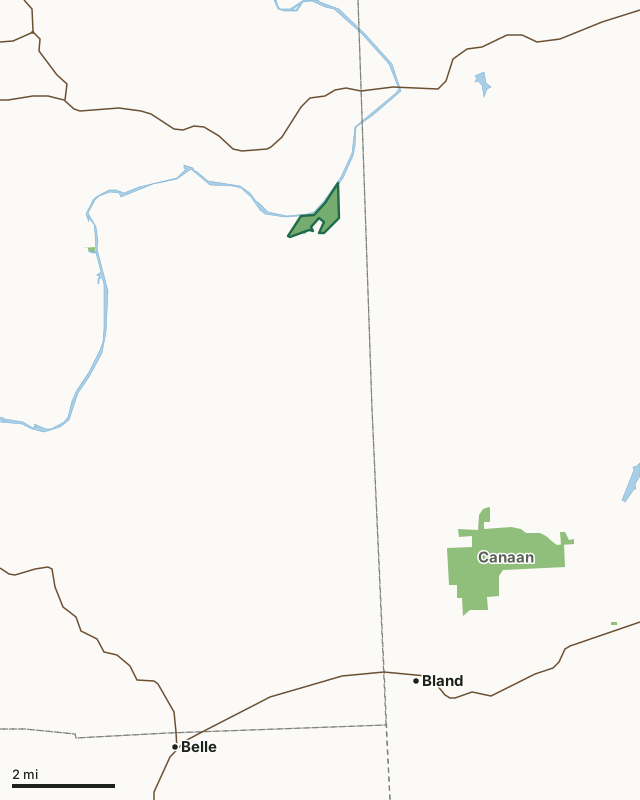
MDC conservation areasCooper Hill Conservation AreaCounty lineLakeHighway
| Size | 219 acres (204 by MDC's page) |
|---|---|
| County | Osage County |
| Deer harvest unit | Osage County |
| MDC lists for hunting | Deer, Bear, Turkey, Squirrel and Dove |
| MDC area number | 9605 |
| MDC region | Central |
| Camping (MDC) | open camping - walk-in/float-in/backpack |
| Nearest towns | Bland (9 mi), Linn (10 mi) and Owensville (10 mi) |
What is Cooper Hill Conservation Area like?
Cooper Hill CA is a mix of bottomland and upland oldfields as well as riparian forest and upland woodland. The area includes some recent reforestation efforts along Third Creek which meets the Gasconade River near the river access. Access is hand launching of boats only as it is a short walk from the parking area to the river.
In MDC's words, from the Cooper Hill Conservation Area page.
What can you hunt on Cooper Hill Conservation Area?
MDC's page for Cooper Hill Conservation Area lists: Deer: muzzleloader and archery, antlerless permits allowed; Bear: archery and firearms; Turkey: archery and firearms; Squirrel; Dove.
What are the rules on Cooper Hill Conservation Area?
MDC's standard conservation area rules (Chapter 11 of the Wildlife Code) apply; the area's rules on MDC's site list any it adds.
How many deer are taken around Cooper Hill Conservation Area?
Cooper Hill Conservation Area lies in Osage County. Hunters checked 3,740 deer in Osage County in 2025, against 3,129 in 2024.
| County | Cooper Hill Conservation Area acres in it | Deer, 2025 | Deer, 2024 | Deer, 2023 |
|---|---|---|---|---|
| Osage County | 219 | 3,740 | 3,129 | 3,966 |
Harvest for the whole county, not the conservation area alone: MDC deer harvest summaries (2021 to 2025 seasons).
How do you get to Cooper Hill Conservation Area?
MDC's directions: From Mt. Sterling, take Route A south 2.50 miles, then Route D west 2.75 miles to the village of Cooper Hill.
Nearest towns: Bland (9 miles), Linn (10 miles), Owensville (10 miles) and Belle (10 miles). Highways within 5 miles: US 50.
What other public land is near Cooper Hill Conservation Area?
MDC lands within 10 miles:
- Canaan Conservation Area: 1,418 acres, 6.2 miles away
Public land within 3 miles of Cooper Hill Conservation Area
Counting Cooper Hill Conservation Area itself, 225 of the 24,575 acres within 3 miles of its boundary are public land open to the public (0.9%), by USGS PAD-US 4.1 and MDC conservation area boundaries.
| Manager | Acres within 3 miles |
|---|---|
| MDC conservation areas | 225 |
Questions hunters ask
Where is Cooper Hill Conservation Area?
In Osage County, 9 miles from Bland.
Can you deer hunt on Cooper Hill Conservation Area?
Yes, by MDC's page: muzzleloader and archery, antlerless permits allowed.
How much public land is around Cooper Hill Conservation Area?
225 acres within 3 miles of its boundary, Cooper Hill Conservation Area included, by USGS PAD-US 4.1 and MDC conservation area boundaries. The closest other MDC area is Canaan Conservation Area (6.2 miles).
Get a Missouri hunt plan when they open
Hunt plans for Missouri are coming. Join the list and you'll hear first. The first 50 hunters in each new state get their plan free.
Until then, the free FilledTag app for iPhone has a map that works in every state, Missouri included.
Where these facts come from
- Area description, species, rules and directions: MDC, Cooper Hill Conservation Area; MDC conservation area boundaries.
- Boundary and acres: MDC's map layer above. Surrounding public land: USGS PAD-US 4.1 (fee land open to the public) and MDC conservation area boundaries.
- Deer harvest: MDC deer harvest summaries (2021 to 2025 seasons).
FilledTag is not part of the Missouri Department of Conservation. Check MDC's rules and posted signs before you go.