Dark Cypress Swamp Unit of Duck Creek Conservation Area: hunting and access
Dark Cypress Swamp Unit of Duck Creek Conservation Area is 786 acres of MDC land in Bollinger County, 4 miles from Advance. MDC lists deer hunting here (archery only, antlerless permits allowed). Hunters checked 3,992 deer in Bollinger County in 2025.
Data updated October 2026. Area facts: MDC's conservation area data, read 2026-10. Harvest: MDC deer harvest summaries, 2021 to 2025.
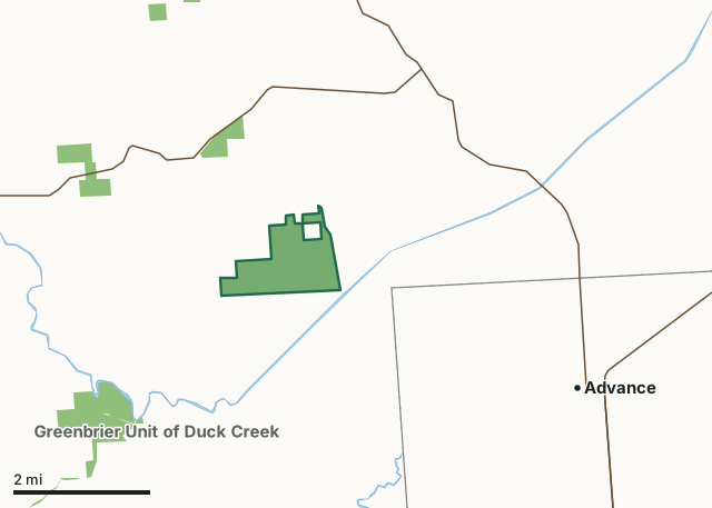
MDC conservation areasDark Cypress Swamp Unit of Duck Creek Conservation AreaCounty lineLakeHighway
| Size | 786 acres |
|---|---|
| County | Bollinger County |
| Deer harvest unit | Bollinger County |
| MDC lists for hunting | Deer, Turkey, Rabbit, Squirrel and Dove |
| MDC area number | 200624 |
| MDC region | Southeast |
| Nearest towns | Advance (4 mi), Zalma (4 mi) and Marble Hill (11 mi) |
What is Dark Cypress Swamp Unit of Duck Creek Conservation Area like?
Duck Creek Conservation Area is now comprised of three units. In addition to the main area on Highway 51, there are two additional units. The Dark Cypress Swamp Unit of Duck Creek Conservation Area occupies the basin where the vast, original Dark Cypress Swamp existed at the time of settlement, so this name has been applied to this parcel. The area formerly named Dark Cypress Swamp, southwest of this Unit along Route C, is now the Greenbrier Unit of Duck Creek.
Dark Cypress Swamp is in southern Bollinger County where the Ozark foothills meet the level floodplain formed when the ancient Mississippi River flowed through the Advance Lowlands. Much of the area was forested as recently as 40 years ago. Subsequent drainage and conversion to farmland left only the wettest land uncut and intact. In 2005, the Department purchased the 790-acre area from The Little River Drainage District. It had already been enrolled in WRP by the Drainage District, so the restoration process began shortly after MDC assumed ownership. Crader Ditch and Hawker Creek (near the east and south property lines), and the nearby Diversion Channel all influence area vegetation through period flooding. Dark Cypress Swamp supports a variety of migratory birds, including waterfowl as well as resident swamp and cottontail rabbits, otter, raccoon, opossum, bobcat, and squirrels.
In MDC's words, from the Dark Cypress Swamp Unit of Duck Creek Conservation Area page.
What can you hunt on Dark Cypress Swamp Unit of Duck Creek Conservation Area?
MDC's page for Dark Cypress Swamp Unit of Duck Creek Conservation Area lists: Deer: archery only, antlerless permits allowed; Turkey: archery and firearms; Rabbit; Squirrel; Dove.
What are the rules on Dark Cypress Swamp Unit of Duck Creek Conservation Area?
Closings: Portions of this department area are closed to protect waterfowl from October 15 through the end of the last segment of the appropriate zone's Canada goose season.
Hunting: Nontoxic shot is required for all hunting with a shotgun on this area. Use or possession of lead shot is prohibited.
Every conservation area also follows MDC's standard rules in Chapter 11 of the Wildlife Code; the area's full rules are on MDC's site.
How many deer are taken around Dark Cypress Swamp Unit of Duck Creek Conservation Area?
Dark Cypress Swamp Unit of Duck Creek Conservation Area lies in Bollinger County. Hunters checked 3,992 deer in Bollinger County in 2025, against 3,291 in 2024.
| County | Dark Cypress Swamp Unit of Duck Creek Conservation Area acres in it | Deer, 2025 | Deer, 2024 | Deer, 2023 |
|---|---|---|---|---|
| Bollinger County | 786 | 3,992 | 3,291 | 4,048 |
Harvest for the whole county, not the conservation area alone: MDC deer harvest summaries (2021 to 2025 seasons).
How do you get to Dark Cypress Swamp Unit of Duck Creek Conservation Area?
MDC's directions: From Advance, take Route C west 7 miles, take County Road 614 north 1 mile to Greenbrier, then Route W north 3 miles, and County Road 604 east for 0.75 mile then turn right (south) for 0.25 mile. The road dead ends at a private drive where the entrance to the area is on the left.
Nearest towns: Advance (4 miles), Zalma (4 miles), Marble Hill (11 miles) and Bell City (11 miles). Highways within 5 miles: MO 51, MO 91 and MO 25.
What other public land is near Dark Cypress Swamp Unit of Duck Creek Conservation Area?
MDC lands within 10 miles:
- Sank Conservation Area: 116 acres, 1.2 miles away
- Greenbrier Unit of Duck Creek Conservation Area: 462 acres, 2 miles away
- Duck Creek Conservation Area: 6,404 acres, 3.4 miles away
- Maple Flats Access: 70 acres, 3.4 miles away
- Sweetgum Access: 159 acres, 6.4 miles away
- Castor River Conservation Area: 10,417 acres, 7 miles away
Public land within 3 miles of Dark Cypress Swamp Unit of Duck Creek Conservation Area
Counting Dark Cypress Swamp Unit of Duck Creek Conservation Area itself, 1,507 of the 28,854 acres within 3 miles of its boundary are public land open to the public (5.2%), by USGS PAD-US 4.1 and MDC conservation area boundaries.
| Manager | Acres within 3 miles |
|---|---|
| MDC conservation areas | 1,507 |
Questions hunters ask
Where is Dark Cypress Swamp Unit of Duck Creek Conservation Area?
In Bollinger County, 4 miles from Advance.
Can you deer hunt on Dark Cypress Swamp Unit of Duck Creek Conservation Area?
Yes, by MDC's page: archery only, antlerless permits allowed.
How much public land is around Dark Cypress Swamp Unit of Duck Creek Conservation Area?
1,507 acres within 3 miles of its boundary, Dark Cypress Swamp Unit of Duck Creek Conservation Area included, by USGS PAD-US 4.1 and MDC conservation area boundaries. The closest other MDC area is Sank Conservation Area (1.2 miles).
Get a Missouri hunt plan when they open
Hunt plans for Missouri are coming. Join the list and you'll hear first. The first 50 hunters in each new state get their plan free.
Until then, the free FilledTag app for iPhone has a map that works in every state, Missouri included.
Where these facts come from
- Area description, species, rules and directions: MDC, Dark Cypress Swamp Unit of Duck Creek Conservation Area; MDC conservation area boundaries.
- Boundary and acres: MDC's map layer above. Surrounding public land: USGS PAD-US 4.1 (fee land open to the public) and MDC conservation area boundaries.
- Deer harvest: MDC deer harvest summaries (2021 to 2025 seasons).
FilledTag is not part of the Missouri Department of Conservation. Check MDC's rules and posted signs before you go.