Deroin Bend Conservation Area: hunting and access
Deroin Bend Conservation Area is 1,218 acres of MDC land in Holt and Atchison counties, 3 miles from Corning. MDC lists deer hunting here (muzzleloader and archery, antlerless permits not allowed). Hunters checked 849 deer in Holt County in 2025.
Data updated October 2026. Area facts: MDC's conservation area data, read 2026-10. Harvest: MDC deer harvest summaries, 2021 to 2025.
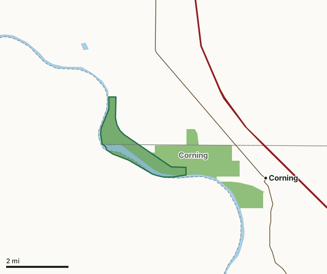
MDC conservation areasDeroin Bend Conservation AreaCounty lineLakeHighway
| Size | 1,218 acres |
|---|---|
| Counties | Holt County and Atchison County |
| Deer harvest unit | Holt County, Atchison County |
| MDC lists for hunting | Deer and Turkey |
| MDC area number | 9615 |
| MDC region | Northwest |
| Camping (MDC) | designated camping sites |
| Nearest towns | Corning (3 mi), Craig (8 mi) and Phelps City (8 mi) |
What is Deroin Bend Conservation Area like?
The Conservation Department purchased this area along the Missouri River after the flood of 1993. The area was acquired to preserve unique wetland and fisheries habitats, and to restore 3.3 miles of the old Missouri River chute, and the 400-acre island.
The area is named after a nearby bend in the river that was originally named after Joseph Deroin, who settled near this area in the 1840's and established the St. Deroin trading post on the bank of the river. The trading post was abandoned in the early 1920's. This area is managed for a wide variety of game and non-game species of fish and wildlife. Rich bottomland soils here produce a wide variety of wetland vegetation and bottomland timber, which are supplemented by plantings of warm-season grasses. Management practices include reforestation, prescribed burning and opportunistic management of wetlands.
In MDC's words, from the Deroin Bend Conservation Area page.
What can you hunt on Deroin Bend Conservation Area?
MDC's page for Deroin Bend Conservation Area lists: Deer: muzzleloader and archery, antlerless permits not allowed; Turkey: archery and firearms.
What are the rules on Deroin Bend Conservation Area?
Hunting: Nontoxic shot is required for all hunting with a shotgun on this area. Use or possession of lead shot is prohibited.
Every conservation area also follows MDC's standard rules in Chapter 11 of the Wildlife Code; the area's full rules are on MDC's site.
How many deer are taken around Deroin Bend Conservation Area?
Deroin Bend Conservation Area lies in 2 counties. Hunters checked 849 deer in Holt County in 2025, against 846 in 2024.
| County | Deroin Bend Conservation Area acres in it | Deer, 2025 | Deer, 2024 | Deer, 2023 |
|---|---|---|---|---|
| Holt County | 680 | 849 | 846 | 835 |
| Atchison County | 472 | 540 | 575 | 562 |
Harvest for the whole county, not the conservation area alone: MDC deer harvest summaries (2021 to 2025 seasons).
How do you get to Deroin Bend Conservation Area?
MDC's directions: From Corning, take Highway 111 northwest 5 miles, then Route Z west 2.50 miles, then Golden Avenue south 0.75 mile.
Nearest towns: Corning (3 miles), Craig (8 miles), Phelps City (8 miles) and Fairfax (8 miles). Highways within 5 miles: I-29 and MO 111.
What other public land is near Deroin Bend Conservation Area?
MDC lands within 10 miles:
- Corning Conservation Area: 1,999 acres, next to it
- Aspinwall Bend: 704 acres, 4.1 miles away
- H. F. Thurnau Conservation Area: 2,476 acres, 4.6 miles away
- Little Tarkio Prairie: 127 acres, 9.9 miles away
Public land within 3 miles of Deroin Bend Conservation Area
Counting Deroin Bend Conservation Area itself, 3,218 of the 35,598 acres within 3 miles of its boundary are public land open to the public (9%), by USGS PAD-US 4.1 and MDC conservation area boundaries.
| Manager | Acres within 3 miles |
|---|---|
| MDC conservation areas | 3,218 |
Questions hunters ask
Where is Deroin Bend Conservation Area?
In Holt and Atchison counties, 3 miles from Corning.
Can you deer hunt on Deroin Bend Conservation Area?
Yes, by MDC's page: muzzleloader and archery, antlerless permits not allowed.
How much public land is around Deroin Bend Conservation Area?
3,218 acres within 3 miles of its boundary, Deroin Bend Conservation Area included, by USGS PAD-US 4.1 and MDC conservation area boundaries. The closest other MDC area is Corning Conservation Area (next to it).
Get a Missouri hunt plan when they open
Hunt plans for Missouri are coming. Join the list and you'll hear first. The first 50 hunters in each new state get their plan free.
Until then, the free FilledTag app for iPhone has a map that works in every state, Missouri included.
Where these facts come from
- Area description, species, rules and directions: MDC, Deroin Bend Conservation Area; MDC conservation area boundaries.
- Boundary and acres: MDC's map layer above. Surrounding public land: USGS PAD-US 4.1 (fee land open to the public) and MDC conservation area boundaries.
- Deer harvest: MDC deer harvest summaries (2021 to 2025 seasons).
FilledTag is not part of the Missouri Department of Conservation. Check MDC's rules and posted signs before you go.