Forest 44 Conservation Area: hunting and access
Forest 44 Conservation Area is 989 acres of MDC land in St. Louis County, next to Valley Park. MDC lists deer hunting here only on managed hunts. Hunters checked 1,922 deer in St. Louis County in 2025.
Data updated October 2026. Area facts: MDC's conservation area data, read 2026-10. Harvest: MDC deer harvest summaries, 2021 to 2025.
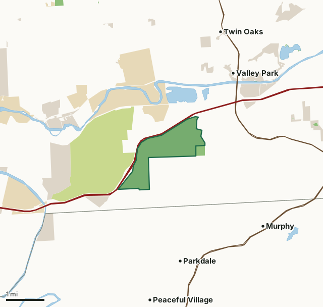
MDC conservation areasState parks and historic sitesOther state landCounty, city and regional landForest 44 Conservation AreaCounty lineLakeHighway
| Size | 989 acres |
|---|---|
| County | St. Louis County |
| Deer harvest unit | St. Louis County |
| MDC area number | 9023 |
| MDC region | St. Louis |
| MDC managed hunts | deer |
| Nearest towns | Valley Park (next to it), Parkdale (2 mi) and Twin Oaks (2 mi) |
What is Forest 44 Conservation Area like?
You might think of Forest 44 as your "Gateway to the Ozarks" from St. Louis County. It lies right along I-44 corridor that conveys travelers to some of the Show-Me State's most scenic places. Several springs on the area feed Williams Creek, which flows along the eastern portion of Forest 44. Flowering dogwood and redbud trees add to the area's natural beauty, especially in the springtime. Hiking, wildlife viewing, and horseback riding are popular activities. An extensive and intertwining trail system covers the area. The Dogwood Ridge trail is reserved for hikers, while the rest of the trails will satisfy both hikers and riders.
In MDC's words, from the Forest 44 Conservation Area page.
What are the rules on Forest 44 Conservation Area?
Closings: Special hours apply on this department area. This area is open to public use only as authorized by posting.
Target Shooting and Shooting Ranges: A staffed shooting range is located on this department area. Target shooting is not allowed anywhere on this area except for designated shooting range(s). Shooting range(s) on this area are open to public use only as authorized by posting. Ranges may be opened or closed at any time for maintenance or department sponsored events or programs. Range use fees apply on this department area. Possession of alcoholic beverages is prohibited on all ranges and associated parking lots. Groups of more than 10 people must obtain a special use permit prior to using the range. To obtain a special use...
Every conservation area also follows MDC's standard rules in Chapter 11 of the Wildlife Code; the area's full rules are on MDC's site.
How many deer are taken around Forest 44 Conservation Area?
Forest 44 Conservation Area lies in St. Louis County. Hunters checked 1,922 deer in St. Louis County in 2025, against 1,917 in 2024.
| County | Forest 44 Conservation Area acres in it | Deer, 2025 | Deer, 2024 | Deer, 2023 |
|---|---|---|---|---|
| St. Louis County | 989 | 1,922 | 1,917 | 2,015 |
Harvest for the whole county, not the conservation area alone: MDC deer harvest summaries (2021 to 2025 seasons).
How do you get to Forest 44 Conservation Area?
MDC's directions: Near the intersection of I-44 and Highway 141 in St. Louis County, take Meramec Station Road off Highway 141 west 1 mile, then left on Hillsboro Road 0.50 mile to the area entrance.
Nearest towns: Valley Park (next to it), Parkdale (2 miles), Twin Oaks (2 miles) and Murphy (3 miles). Highways within 5 miles: US 50, I-44, MO 141, MO 30 and I-270.
What other public land is near Forest 44 Conservation Area?
MDC lands within 10 miles:
- Dorothy E. Aselman Memorial Addition to Forest 44 Conservation Area: 41 acres, next to it
- Simpson Park Lake (St. Louis County): 75 acres, 2.6 miles away
- Roger Klamberg Woods Conservation Area: 68 acres, 4.1 miles away
Public land within 3 miles of Forest 44 Conservation Area
Counting Forest 44 Conservation Area itself, 6,235 of the 31,851 acres within 3 miles of its boundary are public land open to the public (19.6%), by USGS PAD-US 4.1 and MDC conservation area boundaries.
| Manager | Acres within 3 miles |
|---|---|
| Other state land | 1,903 |
| State parks and historic sites | 1,762 |
| County, city and regional land | 1,478 |
| MDC conservation areas | 1,092 |
Questions hunters ask
Where is Forest 44 Conservation Area?
In St. Louis County, next to Valley Park.
Can you deer hunt on Forest 44 Conservation Area?
Only on MDC managed hunts, by MDC's page. Managed hunts are applied for through MDC.
How much public land is around Forest 44 Conservation Area?
6,235 acres within 3 miles of its boundary, Forest 44 Conservation Area included, by USGS PAD-US 4.1 and MDC conservation area boundaries. The closest other MDC area is Dorothy E. Aselman Memorial Addition to Forest 44 Conservation Area (next to it).
Get a Missouri hunt plan when they open
Hunt plans for Missouri are coming. Join the list and you'll hear first. The first 50 hunters in each new state get their plan free.
Until then, the free FilledTag app for iPhone has a map that works in every state, Missouri included.
Where these facts come from
- Area description, species, rules and directions: MDC, Forest 44 Conservation Area; MDC conservation area boundaries.
- Boundary and acres: MDC's map layer above. Surrounding public land: USGS PAD-US 4.1 (fee land open to the public) and MDC conservation area boundaries.
- Deer harvest: MDC deer harvest summaries (2021 to 2025 seasons).
FilledTag is not part of the Missouri Department of Conservation. Check MDC's rules and posted signs before you go.