General Watkins Conservation Area: hunting and access
General Watkins Conservation Area is 1,115 acres of MDC land in Scott County, next to Morley. MDC lists deer hunting here (archery and firearms, archery antlerless permits only). Hunters checked 900 deer in Scott County in 2025.
Data updated October 2026. Area facts: MDC's conservation area data, read 2026-10. Harvest: MDC deer harvest summaries, 2021 to 2025.
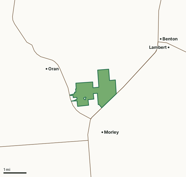
MDC conservation areasGeneral Watkins Conservation AreaCounty lineHighway
| Size | 1,115 acres |
|---|---|
| County | Scott County |
| Deer harvest unit | Scott County |
| MDC lists for hunting | Deer, Bear, Turkey, Rabbit, Squirrel and Quail |
| MDC area number | 7903 |
| MDC region | Southeast |
| Camping (MDC) | designated camping sites and individual campsites |
| Nearest towns | Morley (next to it), Oran (next to it) and Benton (3 mi) |
What is General Watkins Conservation Area like?
General Watkins Conservation Area is in Scott County, 14 miles north of Sikeston and 15 miles south of Cape Girardeau. The area can be reached from Highway 61 and Highway 77 and from county gravel roads.
General Watkins Conservation Area contains a forest type more closely resembling Appalachian than Missouri forests. Sweetgum, American beech, cucumber tree and tulip poplar are found here, along with tree species more common to Missouri, like white and red oak, maple, hickory and walnut. This mesic beech-oak forest type has spicebush, dogwood and paw paw growing in the shrub layer. The ground layer is dominated by Virginia creeper and poison ivy and also includes Christmas fern, broad beech fern and the state-rare beech drops and Virginia pennywort. Beech drops are brown-purple and grow only in beech forests; they are parasitic on beech roots. The pale green pennywort has pale lilac flowers in early spring but is difficult to find being only a few inches tall. Natural erosion has worn steep-sided canyons up to 50 feet deep through the area's loess soils. People walking near these...
In MDC's words, from the General Watkins Conservation Area page.
What can you hunt on General Watkins Conservation Area?
MDC's page for General Watkins Conservation Area lists: Deer: archery and firearms, archery antlerless permits only; Bear: archery and firearms; Turkey: archery and firearms; Rabbit; Squirrel; Quail.
What are the rules on General Watkins Conservation Area?
MDC's standard conservation area rules (Chapter 11 of the Wildlife Code) apply; the area's rules on MDC's site list any it adds.
How many deer are taken around General Watkins Conservation Area?
General Watkins Conservation Area lies in Scott County. Hunters checked 900 deer in Scott County in 2025, against 930 in 2024.
| County | General Watkins Conservation Area acres in it | Deer, 2025 | Deer, 2024 | Deer, 2023 |
|---|---|---|---|---|
| Scott County | 1,115 | 900 | 930 | 914 |
Harvest for the whole county, not the conservation area alone: MDC deer harvest summaries (2021 to 2025 seasons).
How do you get to General Watkins Conservation Area?
MDC's directions: From Benton, take Highway 61 south 3 miles to the east side of the area. From Oran, take Highway 77 south 1.5 miles to the southwest side of the area.
Nearest towns: Morley (next to it), Oran (next to it), Benton (3 miles) and Lambert (3 miles). Highways within 5 miles: I-55, MO 77, US 61 and MO 91.
What other public land is near General Watkins Conservation Area?
MDC lands within 10 miles:
- Sand Prairie Conservation Area: 198 acres, 5.4 miles away
- Tywappity Community Lake: 119 acres, 7.4 miles away
- Tywappity Towersite: 62 acres, 7.8 miles away
Public land within 3 miles of General Watkins Conservation Area
Counting General Watkins Conservation Area itself, 1,115 of the 30,997 acres within 3 miles of its boundary are public land open to the public (3.6%), by USGS PAD-US 4.1 and MDC conservation area boundaries.
| Manager | Acres within 3 miles |
|---|---|
| MDC conservation areas | 1,115 |
Questions hunters ask
Where is General Watkins Conservation Area?
In Scott County, next to Morley.
Can you deer hunt on General Watkins Conservation Area?
Yes, by MDC's page: archery and firearms, archery antlerless permits only.
How much public land is around General Watkins Conservation Area?
1,115 acres within 3 miles of its boundary, General Watkins Conservation Area included, by USGS PAD-US 4.1 and MDC conservation area boundaries. The closest other MDC area is Sand Prairie Conservation Area (5.4 miles).
Get a Missouri hunt plan when they open
Hunt plans for Missouri are coming. Join the list and you'll hear first. The first 50 hunters in each new state get their plan free.
Until then, the free FilledTag app for iPhone has a map that works in every state, Missouri included.
Where these facts come from
- Area description, species, rules and directions: MDC, General Watkins Conservation Area; MDC conservation area boundaries.
- Boundary and acres: MDC's map layer above. Surrounding public land: USGS PAD-US 4.1 (fee land open to the public) and MDC conservation area boundaries.
- Deer harvest: MDC deer harvest summaries (2021 to 2025 seasons).
FilledTag is not part of the Missouri Department of Conservation. Check MDC's rules and posted signs before you go.