Graves Mountain Conservation Area: hunting and access
Graves Mountain Conservation Area is 3,275 acres of MDC land in Wayne and Iron counties, next to Des Arc. MDC lists deer hunting here (archery and firearms, archery antlerless permits only). Hunters checked 4,081 deer in Wayne County in 2025.
Data updated October 2026. Area facts: MDC's conservation area data, read 2026-10. Harvest: MDC deer harvest summaries, 2021 to 2025.
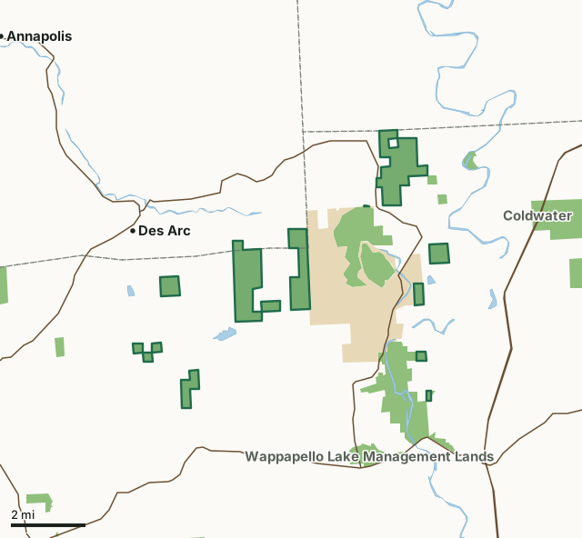
MDC conservation areasState parks and historic sitesGraves Mountain Conservation AreaCounty lineLakeHighway
| Size | 3,275 acres (3,028 by MDC's page) in 13 pieces |
|---|---|
| Counties | Wayne County and Iron County |
| Deer harvest unit | Wayne County, Iron County |
| MDC lists for hunting | Deer, Bear, Turkey and Squirrel |
| MDC area number | 4621 |
| MDC region | Southeast |
| Camping (MDC) | open camping - walk-in/float-in/backpack and individual campsites |
| Nearest towns | Des Arc (next to it), Piedmont (6 mi) and Greenville (6 mi) |
What is Graves Mountain Conservation Area like?
This is a forest area.This area has unimproved roads that are open to public vehicles. These roads may not be shown on area maps or posted with signs. Road conditions may vary.
In MDC's words, from the Graves Mountain Conservation Area page.
What can you hunt on Graves Mountain Conservation Area?
MDC's page for Graves Mountain Conservation Area lists: Deer: archery and firearms, archery antlerless permits only; Bear: archery and firearms; Turkey: archery and firearms; Squirrel.
What are the rules on Graves Mountain Conservation Area?
MDC's standard conservation area rules (Chapter 11 of the Wildlife Code) apply; the area's rules on MDC's site list any it adds.
How many deer are taken around Graves Mountain Conservation Area?
Graves Mountain Conservation Area lies in 2 counties. Hunters checked 4,081 deer in Wayne County in 2025, against 2,680 in 2024.
| County | Graves Mountain Conservation Area acres in it | Deer, 2025 | Deer, 2024 | Deer, 2023 |
|---|---|---|---|---|
| Wayne County | 3,063 | 4,081 | 2,680 | 4,014 |
| Iron County | 212 | 1,903 | 1,240 | 1,843 |
Harvest for the whole county, not the conservation area alone: MDC deer harvest summaries (2021 to 2025 seasons).
How do you get to Graves Mountain Conservation Area?
MDC's directions: From Sam A. Baker State Park, take Highway 143 north to the area main tract.
Nearest towns: Des Arc (next to it), Piedmont (6 miles), Greenville (6 miles) and Annapolis (8 miles). Highways within 5 miles: US 67, MO 34, MO 143 and MO 49.
What other public land is near Graves Mountain Conservation Area?
MDC lands within 10 miles:
- Wappapello Lake Management Lands: 1,892 acres, next to it
- Coldwater Access: 78 acres, 1 mile away
- Riverside Conservation Area: 2,654 acres, 1.8 miles away
- Coldwater Conservation Area: 11,723 acres, 2.3 miles away
- Flatwoods Conservation Area: 944 acres, 3.5 miles away
- Lon Sanders Canyon Conservation Area: 128 acres, 4.3 miles away
Public land within 3 miles of Graves Mountain Conservation Area
Counting Graves Mountain Conservation Area itself, 11,317 of the 91,225 acres within 3 miles of its boundary are public land open to the public (12.4%), by USGS PAD-US 4.1 and MDC conservation area boundaries.
| Manager | Acres within 3 miles |
|---|---|
| MDC conservation areas | 7,150 |
| State parks and historic sites | 4,167 |
Questions hunters ask
Where is Graves Mountain Conservation Area?
In Wayne and Iron counties, next to Des Arc.
Can you deer hunt on Graves Mountain Conservation Area?
Yes, by MDC's page: archery and firearms, archery antlerless permits only.
How much public land is around Graves Mountain Conservation Area?
11,317 acres within 3 miles of its boundary, Graves Mountain Conservation Area included, by USGS PAD-US 4.1 and MDC conservation area boundaries. The closest other MDC area is Wappapello Lake Management Lands (next to it).
Get a Missouri hunt plan when they open
Hunt plans for Missouri are coming. Join the list and you'll hear first. The first 50 hunters in each new state get their plan free.
Until then, the free FilledTag app for iPhone has a map that works in every state, Missouri included.
Where these facts come from
- Area description, species, rules and directions: MDC, Graves Mountain Conservation Area; MDC conservation area boundaries.
- Boundary and acres: MDC's map layer above. Surrounding public land: USGS PAD-US 4.1 (fee land open to the public) and MDC conservation area boundaries.
- Deer harvest: MDC deer harvest summaries (2021 to 2025 seasons).
FilledTag is not part of the Missouri Department of Conservation. Check MDC's rules and posted signs before you go.