Holly Ridge Conservation Area: hunting and access
Holly Ridge Conservation Area is 1,012 acres of MDC land in Stoddard County, 2 miles from Bloomfield. MDC lists deer hunting here (archery and firearms, archery antlerless permits only). Hunters checked 1,935 deer in Stoddard County in 2025.
Data updated October 2026. Area facts: MDC's conservation area data, read 2026-10. Harvest: MDC deer harvest summaries, 2021 to 2025.
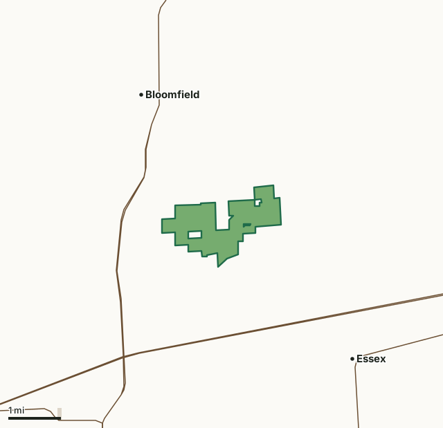
MDC conservation areasCounty, city and regional landHolly Ridge Conservation AreaCounty lineHighway
| Size | 1,012 acres |
|---|---|
| County | Stoddard County |
| Deer harvest unit | Stoddard County |
| MDC lists for hunting | Deer, Bear, Turkey, Rabbit, Squirrel, Dove and Quail |
| MDC area number | 6920 |
| MDC region | Southeast |
| Camping (MDC) | open camping - walk-in/float-in/backpack and individual campsites |
| Shooting range (MDC) | archery |
| Nearest towns | Bloomfield (2 mi), Essex (3 mi) and Dexter (4 mi) |
What is Holly Ridge Conservation Area like?
Holly Ridge Conservation Area is in Stoddard County four miles northeast of Dexter. The area can be reached from gravel county roads off Highway 60 and Route E. Two natural areas, Holly Ridge and Beech Springs, are located here. The 84-acre Holly Ridge Natural Area protects 26 rare or endangered plant species. Beech Springs Natural Area consists of 35 acres and was established to protect the perched bog, sometimes called a hanging bog. A perched bog is a natural pond located on an upland site. This particular bog is surrounded by a stand of large red, black, and white oak. During your visit to Holly Ridge CA, you may view various forest improvement practices designed to improve wildlife habitat, maintain watershed quality, and to enhance tree growth, quality, and species composition. Signs of disturbance are only temporary and the forest will soon return to normal. Wildlife management practices include planting fields to serve as food sources for animals, creating watering ponds and harvesting timber, which provides improved forage and cover for wildlife.
In MDC's words, from the Holly Ridge Conservation Area page.
What can you hunt on Holly Ridge Conservation Area?
MDC's page for Holly Ridge Conservation Area lists: Deer: archery and firearms, archery antlerless permits only; Bear: archery and firearms; Turkey: archery and firearms; Rabbit; Squirrel; Dove; Quail.
What are the rules on Holly Ridge Conservation Area?
Target Shooting and Shooting Ranges: An unstaffed range is located on this department area. Target shooting is not allowed anywhere on this area except for designated shooting range(s). Shooting hours are one-half hour before sunrise to one-half hour after sunset. Ranges may be closed to public use at any time for maintenance or department sponsored events or programs. Possession of alcoholic beverages is prohibited on all ranges and associated parking lots. Groups of more than 10 people must obtain a special use permit prior to using the range. To obtain a special use permit, contact the area manager at the phone number listed...
Every conservation area also follows MDC's standard rules in Chapter 11 of the Wildlife Code; the area's full rules are on MDC's site.
How many deer are taken around Holly Ridge Conservation Area?
Holly Ridge Conservation Area lies in Stoddard County. Hunters checked 1,935 deer in Stoddard County in 2025, against 2,117 in 2024.
| County | Holly Ridge Conservation Area acres in it | Deer, 2025 | Deer, 2024 | Deer, 2023 |
|---|---|---|---|---|
| Stoddard County | 1,012 | 1,935 | 2,117 | 2,158 |
Harvest for the whole county, not the conservation area alone: MDC deer harvest summaries (2021 to 2025 seasons).
How do you get to Holly Ridge Conservation Area?
MDC's directions: From Bloomfield, take Highway E east for 0.3 miles, then turn right onto County Road 517 and head south for 2.3 miles to the area.
Nearest towns: Bloomfield (2 miles), Essex (3 miles), Dexter (4 miles) and Penermon (5 miles). Highways within 5 miles: US 60, MO 25, MO 114 and MO 153.
What other public land is near Holly Ridge Conservation Area?
MDC lands within 10 miles:
- Crowleys Ridge Conservation Area: 1,928 acres, 6 miles away
- Aquilla Access: 88 acres, 7 miles away
Public land within 3 miles of Holly Ridge Conservation Area
Counting Holly Ridge Conservation Area itself, 1,013 of the 31,029 acres within 3 miles of its boundary are public land open to the public (3.3%), by USGS PAD-US 4.1 and MDC conservation area boundaries.
| Manager | Acres within 3 miles |
|---|---|
| MDC conservation areas | 1,013 |
Questions hunters ask
Where is Holly Ridge Conservation Area?
In Stoddard County, 2 miles from Bloomfield.
Can you deer hunt on Holly Ridge Conservation Area?
Yes, by MDC's page: archery and firearms, archery antlerless permits only.
How much public land is around Holly Ridge Conservation Area?
1,013 acres within 3 miles of its boundary, Holly Ridge Conservation Area included, by USGS PAD-US 4.1 and MDC conservation area boundaries. The closest other MDC area is Crowleys Ridge Conservation Area (6 miles).
Get a Missouri hunt plan when they open
Hunt plans for Missouri are coming. Join the list and you'll hear first. The first 50 hunters in each new state get their plan free.
Until then, the free FilledTag app for iPhone has a map that works in every state, Missouri included.
Where these facts come from
- Area description, species, rules and directions: MDC, Holly Ridge Conservation Area; MDC conservation area boundaries.
- Boundary and acres: MDC's map layer above. Surrounding public land: USGS PAD-US 4.1 (fee land open to the public) and MDC conservation area boundaries.
- Deer harvest: MDC deer harvest summaries (2021 to 2025 seasons).
FilledTag is not part of the Missouri Department of Conservation. Check MDC's rules and posted signs before you go.