Hughes Mountain Natural Area: hunting and access
Hughes Mountain Natural Area is 460 acres of MDC land in Washington County, 3 miles from Irondale. MDC lists deer hunting here (archery and firearms, antlerless permits allowed). Hunters checked 3,425 deer in Washington County in 2025.
Data updated October 2026. Area facts: MDC's conservation area data, read 2026-10. Harvest: MDC deer harvest summaries, 2021 to 2025.
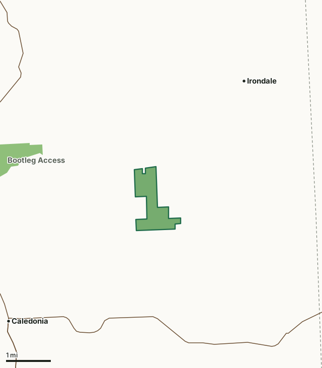
MDC conservation areasHughes Mountain Natural AreaCounty lineHighway
| Size | 460 acres |
|---|---|
| County | Washington County |
| Deer harvest unit | Washington County |
| MDC lists for hunting | Deer, Bear, Turkey and Squirrel |
| MDC area number | 8252 |
| MDC region | St. Louis |
| Nearest towns | Irondale (3 mi), Caledonia (3 mi) and Bismarck (5 mi) |
What is Hughes Mountain Natural Area like?
Hughes Mountain entices explorers with some of the most unique geological features in the Show-Me-State. The 1.5 billion year old Precambrian rock outcrops are among the most ancient exposed rocks in the United States. The rocks were once liquefied by ancient volcanoes associated with the St. Francois Mountains. Some of the molten rock contracted and cracked as it cooled to create multi-sided columns. A rhyolite formation, known locally as the Devil's Honeycomb, is one of Missouri's geologic wonders, and is the highest point on Hughes Mountain.
Sunsets are spectacular from Devil's Honeycomb as well, with its panoramic western view of the Washington County countryside. Prepare for a bit of a climb as you travel the one-mile trail to get there, but the rewards are well worth it.
In MDC's words, from the Hughes Mountain Natural Area page.
What can you hunt on Hughes Mountain Natural Area?
MDC's page for Hughes Mountain Natural Area lists: Deer: archery and firearms, antlerless permits allowed; Bear: archery and firearms; Turkey: archery and firearms; Squirrel.
What are the rules on Hughes Mountain Natural Area?
MDC's standard conservation area rules (Chapter 11 of the Wildlife Code) apply; the area's rules on MDC's site list any it adds.
How many deer are taken around Hughes Mountain Natural Area?
Hughes Mountain Natural Area lies in Washington County. Hunters checked 3,425 deer in Washington County in 2025, against 2,485 in 2024.
| County | Hughes Mountain Natural Area acres in it | Deer, 2025 | Deer, 2024 | Deer, 2023 |
|---|---|---|---|---|
| Washington County | 460 | 3,425 | 2,485 | 4,106 |
Harvest for the whole county, not the conservation area alone: MDC deer harvest summaries (2021 to 2025 seasons).
How do you get to Hughes Mountain Natural Area?
MDC's directions: From Potosi, take Highway 21 south 11 miles, then Route M east 5 miles to parking lot on south side of road 200 yards east of Cedar Creek Road (CR 541).
Nearest towns: Irondale (3 miles), Caledonia (3 miles), Bismarck (5 miles) and Wortham (6 miles). Highways within 5 miles: MO 32 and MO 21.
What other public land is near Hughes Mountain Natural Area?
MDC lands within 10 miles:
- Bootleg Access: 289 acres, 2.1 miles away
- Buford Mountain Conservation Area: 4,058 acres, 3.3 miles away
- Bismarck Conservation Area: 1,159 acres, 4.6 miles away
Public land within 3 miles of Hughes Mountain Natural Area
Counting Hughes Mountain Natural Area itself, 705 of the 26,989 acres within 3 miles of its boundary are public land open to the public (2.6%), by USGS PAD-US 4.1 and MDC conservation area boundaries.
| Manager | Acres within 3 miles |
|---|---|
| MDC conservation areas | 705 |
Questions hunters ask
Where is Hughes Mountain Natural Area?
In Washington County, 3 miles from Irondale.
Can you deer hunt on Hughes Mountain Natural Area?
Yes, by MDC's page: archery and firearms, antlerless permits allowed.
How much public land is around Hughes Mountain Natural Area?
705 acres within 3 miles of its boundary, Hughes Mountain Natural Area included, by USGS PAD-US 4.1 and MDC conservation area boundaries. The closest other MDC area is Bootleg Access (2.1 miles).
Get a Missouri hunt plan when they open
Hunt plans for Missouri are coming. Join the list and you'll hear first. The first 50 hunters in each new state get their plan free.
Until then, the free FilledTag app for iPhone has a map that works in every state, Missouri included.
Where these facts come from
- Area description, species, rules and directions: MDC, Hughes Mountain Natural Area; MDC conservation area boundaries.
- Boundary and acres: MDC's map layer above. Surrounding public land: USGS PAD-US 4.1 (fee land open to the public) and MDC conservation area boundaries.
- Deer harvest: MDC deer harvest summaries (2021 to 2025 seasons).
FilledTag is not part of the Missouri Department of Conservation. Check MDC's rules and posted signs before you go.