Indian Trail Conservation Area: hunting and access
Indian Trail Conservation Area is 13,562 acres of MDC land in Dent County, 7 miles from Salem. MDC lists deer hunting here (archery and firearms, antlerless permits allowed). Hunters checked 2,659 deer in Dent County in 2025.
Data updated October 2026. Area facts: MDC's conservation area data, read 2026-10. Harvest: MDC deer harvest summaries, 2021 to 2025.
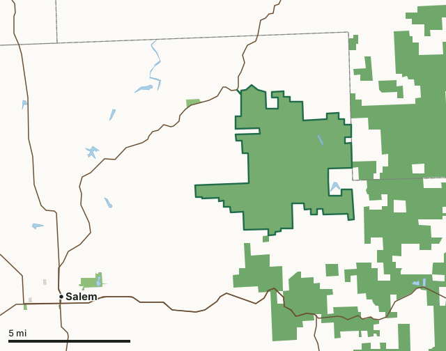
MDC conservation areasNational forestCounty, city and regional landIndian Trail Conservation AreaCounty lineLakeHighway
| Size | 13,562 acres |
|---|---|
| County | Dent County |
| Deer harvest unit | Dent County |
| MDC lists for hunting | Deer, Bear, Turkey, Rabbit, Squirrel and Dove |
| MDC area number | 6201 |
| MDC region | Ozark |
| Camping (MDC) | designated camping sites and individual campsites |
| Shooting range (MDC) | rifle or pistol |
| Nearest towns | Salem (7 mi), Viburnum (10 mi) and Steelville (15 mi) |
What is Indian Trail Conservation Area like?
Indian Trail Conservation Area covers 13,503 acres in northeast Dent County, between Salem and Steelville. The entrance to the area is off Highway 19.
The area is mostly forested, but also includes glades, food plots, streams, and ponds. The area contains an intricate mosaic of dolomite glades and chert savannas with open-grown trees on exposed slopes. The canopy of the slopes is dominated by post, black, white, and blackjack oaks and hickories. The ground cover of the glades and savannas includes grasses such as little bluestem, big bluestem, sideoats, grama and Indian grass, as well as wildflowers such as white and purple prairie clovers and glade coneflower. Dolomite bedrock outcrops and ledges are scattered throughout the glades. Formerly, the area was the site of the Sligo Iron Company. Heavy cutting of cordwood to fuel the smelters depleted local timber supplies, eventually forcing the iron works to close. Private owners acquired the Indian Trail area in 1906 for use as rangeland. Grazing and burning to encourage grass growth...
In MDC's words, from the Indian Trail Conservation Area page.
What can you hunt on Indian Trail Conservation Area?
MDC's page for Indian Trail Conservation Area lists: Deer: archery and firearms, antlerless permits allowed; Bear: archery and firearms; Turkey: archery and firearms; Rabbit; Squirrel; Dove.
What are the rules on Indian Trail Conservation Area?
Target Shooting and Shooting Ranges: An unstaffed range is located on this department area. Target shooting is not allowed anywhere on this area except for designated shooting range(s). Shooting hours are one-half hour before sunrise to one-half hour after sunset. Ranges may be closed to public use at any time for maintenance or department sponsored events or programs. Possession of alcoholic beverages is prohibited on all ranges and associated parking lots. Groups of more than 10 people must obtain a special use permit prior to using the range. To obtain a special use permit, contact the area manager at the phone number listed...
Every conservation area also follows MDC's standard rules in Chapter 11 of the Wildlife Code; the area's full rules are on MDC's site.
How many deer are taken around Indian Trail Conservation Area?
Indian Trail Conservation Area lies in Dent County. Hunters checked 2,659 deer in Dent County in 2025, against 2,584 in 2024.
| County | Indian Trail Conservation Area acres in it | Deer, 2025 | Deer, 2024 | Deer, 2023 |
|---|---|---|---|---|
| Dent County | 13,562 | 2,659 | 2,584 | 3,865 |
Harvest for the whole county, not the conservation area alone: MDC deer harvest summaries (2021 to 2025 seasons).
How do you get to Indian Trail Conservation Area?
MDC's directions: From Salem, take Highway 19 northeast 12 miles to the area.
Nearest towns: Salem (7 miles), Viburnum (10 miles), Steelville (15 miles) and Bunker (16 miles). Highways within 5 miles: MO 19, MO 32 and MO 72.
What other public land is near Indian Trail Conservation Area?
MDC lands within 10 miles:
- Short Bend Access: 79 acres, 1.5 miles away
- Shawnee Mac Lakes Conservation Area: 249 acres, 4.9 miles away
- Crooked Creek Conservation Area: 332 acres, 6.7 miles away
Public land within 3 miles of Indian Trail Conservation Area
Counting Indian Trail Conservation Area itself, 26,696 of the 76,241 acres within 3 miles of its boundary are public land open to the public (35%), by USGS PAD-US 4.1 and MDC conservation area boundaries.
| Manager | Acres within 3 miles |
|---|---|
| MDC conservation areas | 13,643 |
| National forest | 13,053 |
Questions hunters ask
Where is Indian Trail Conservation Area?
In Dent County, 7 miles from Salem.
Can you deer hunt on Indian Trail Conservation Area?
Yes, by MDC's page: archery and firearms, antlerless permits allowed.
How much public land is around Indian Trail Conservation Area?
26,696 acres within 3 miles of its boundary, Indian Trail Conservation Area included, by USGS PAD-US 4.1 and MDC conservation area boundaries. The closest other MDC area is Short Bend Access (1.5 miles).
Get a Missouri hunt plan when they open
Hunt plans for Missouri are coming. Join the list and you'll hear first. The first 50 hunters in each new state get their plan free.
Until then, the free FilledTag app for iPhone has a map that works in every state, Missouri included.
Where these facts come from
- Area description, species, rules and directions: MDC, Indian Trail Conservation Area; MDC conservation area boundaries.
- Boundary and acres: MDC's map layer above. Surrounding public land: USGS PAD-US 4.1 (fee land open to the public) and MDC conservation area boundaries.
- Deer harvest: MDC deer harvest summaries (2021 to 2025 seasons).
FilledTag is not part of the Missouri Department of Conservation. Check MDC's rules and posted signs before you go.