LaBarque Creek Conservation Area: hunting and access
LaBarque Creek Conservation Area is 1,284 acres of MDC land in Jefferson County, next to LaBarque Creek. MDC lists deer hunting here (archery only, antlerless permits allowed). Hunters checked 5,173 deer in Jefferson County in 2025.
Data updated October 2026. Area facts: MDC's conservation area data, read 2026-10. Harvest: MDC deer harvest summaries, 2021 to 2025.
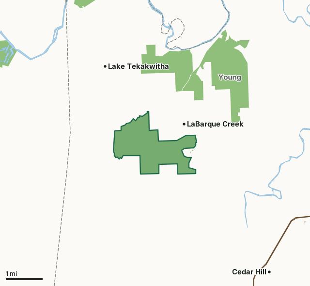
MDC conservation areasCounty, city and regional landLaBarque Creek Conservation AreaCounty lineLakeHighway
| Size | 1,284 acres |
|---|---|
| County | Jefferson County |
| Deer harvest unit | Jefferson County |
| MDC lists for hunting | Deer, Bear, Turkey and Squirrel |
| MDC area number | 200608 |
| MDC region | St. Louis |
| Nearest towns | LaBarque Creek (next to it), Lake Tekakwitha (2 mi) and Cedar Hill (3 mi) |
What is LaBarque Creek Conservation Area like?
LaBarque Creek Conservation Area is one of the finest outdoor destinations in Jefferson County. Its rugged, forested hills and steep, narrow valleys, and canyons offer a brilliant hiking experience along its trail, which is approximately three miles long. The bluffs and shelter caves youll see are carved into St. Peter sandstone. Visit after a rain to catch some beautiful water flows or in midwinter for spectacular ice formations. The LaBarque Creek watershed is a true aquatic gem, with at least 54 species of fish and a diversity almost three times greater than that of any of the 15 other tributaries of the Meramec River below LaBarque.
In MDC's words, from the LaBarque Creek Conservation Area page.
What can you hunt on LaBarque Creek Conservation Area?
MDC's page for LaBarque Creek Conservation Area lists: Deer: archery only, antlerless permits allowed; Bear: archery only; Turkey: archery and firearms; Squirrel.
What are the rules on LaBarque Creek Conservation Area?
MDC's standard conservation area rules (Chapter 11 of the Wildlife Code) apply; the area's rules on MDC's site list any it adds.
How many deer are taken around LaBarque Creek Conservation Area?
LaBarque Creek Conservation Area lies in Jefferson County. Hunters checked 5,173 deer in Jefferson County in 2025, against 4,890 in 2024.
| County | LaBarque Creek Conservation Area acres in it | Deer, 2025 | Deer, 2024 | Deer, 2023 |
|---|---|---|---|---|
| Jefferson County | 1,284 | 5,173 | 4,890 | 5,757 |
Harvest for the whole county, not the conservation area alone: MDC deer harvest summaries (2021 to 2025 seasons).
How do you get to LaBarque Creek Conservation Area?
MDC's directions: From Eureka, take Highway 109 south to Route FF west, then Route F south approximately 100 feet, then Doc Sargent Road west, then Valley Drive south about 0.50 mile to the parking lot.
Nearest towns: LaBarque Creek (next to it), Lake Tekakwitha (2 miles), Cedar Hill (3 miles) and Scotsdale (5 miles). Highways within 5 miles: MO 30 and US 66.
What other public land is near LaBarque Creek Conservation Area?
MDC lands within 10 miles:
- Myron and Sonya Glassberg Family Conservation Area: 628 acres, 0.9 miles away
- Young Conservation Area: 1,278 acres, 1 mile away
- Pacific Palisades Conservation Area: 732 acres, 3.3 miles away
- Catawissa Conservation Area: 216 acres, 3.4 miles away
- Rockwoods Range: 1,461 acres, 5.7 miles away
- River 'Round Conservation Area: 314 acres, 8.5 miles away
Public land within 3 miles of LaBarque Creek Conservation Area
Counting LaBarque Creek Conservation Area itself, 3,194 of the 32,588 acres within 3 miles of its boundary are public land open to the public (9.8%), by USGS PAD-US 4.1 and MDC conservation area boundaries.
| Manager | Acres within 3 miles |
|---|---|
| MDC conservation areas | 3,194 |
Questions hunters ask
Where is LaBarque Creek Conservation Area?
In Jefferson County, next to LaBarque Creek.
Can you deer hunt on LaBarque Creek Conservation Area?
Yes, by MDC's page: archery only, antlerless permits allowed.
How much public land is around LaBarque Creek Conservation Area?
3,194 acres within 3 miles of its boundary, LaBarque Creek Conservation Area included, by USGS PAD-US 4.1 and MDC conservation area boundaries. The closest other MDC area is Myron and Sonya Glassberg Family Conservation Area (0.9 miles).
Get a Missouri hunt plan when they open
Hunt plans for Missouri are coming. Join the list and you'll hear first. The first 50 hunters in each new state get their plan free.
Until then, the free FilledTag app for iPhone has a map that works in every state, Missouri included.
Where these facts come from
- Area description, species, rules and directions: MDC, LaBarque Creek Conservation Area; MDC conservation area boundaries.
- Boundary and acres: MDC's map layer above. Surrounding public land: USGS PAD-US 4.1 (fee land open to the public) and MDC conservation area boundaries.
- Deer harvest: MDC deer harvest summaries (2021 to 2025 seasons).
FilledTag is not part of the Missouri Department of Conservation. Check MDC's rules and posted signs before you go.