LaBelle Lake Conservation Area: hunting and access
LaBelle Lake Conservation Area is 350 acres of MDC land in Lewis County, next to La Belle. MDC lists deer hunting here (archery only, antlerless permits allowed). Hunters checked 2,407 deer in Lewis County in 2025.
Data updated October 2026. Area facts: MDC's conservation area data, read 2026-10. Harvest: MDC deer harvest summaries, 2021 to 2025.
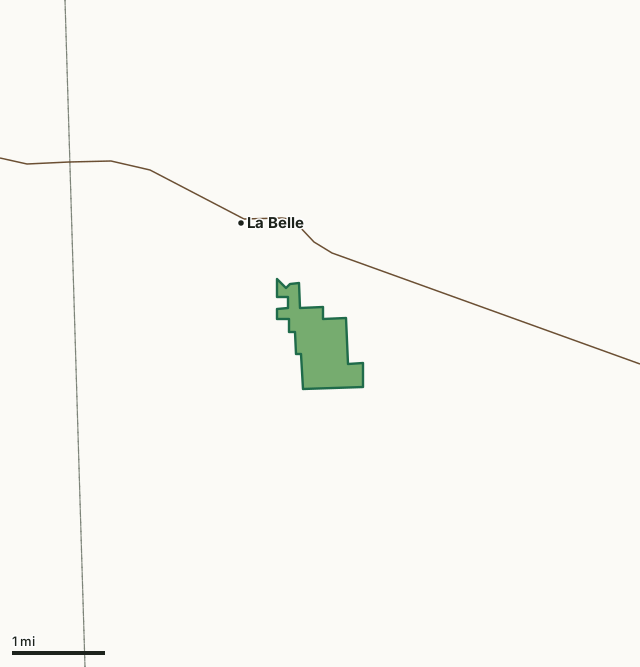
MDC conservation areasLaBelle Lake Conservation AreaCounty lineHighway
| Size | 350 acres |
|---|---|
| County | Lewis County |
| Deer harvest unit | Lewis County |
| MDC lists for hunting | Deer, Turkey, Rabbit, Squirrel, Dove and Quail |
| MDC area number | 200402 |
| MDC region | Northeast |
| Camping (MDC) | walk-in, float-in or backpack camping (not during deer and turkey seasons) and individual campsites |
| Nearest towns | La Belle (next to it), Lewistown (4 mi) and Knox City (6 mi) |
What is LaBelle Lake Conservation Area like?
The original General Land Office survey of Lewis County, conducted in the 1840's, mapped the entirety of Labelle Lake CA as prairie. However, justone-half mile south and west of the area, open, upland prairie transitioned into the Troublesome Creek floodplain, which was at least partially wooded. This landscape pattern was characteristic of the region as described in the following passage excerpted from "Presettlement Prairie of Missouri" (Walter Schroeder): A second physiographic expression of prairie in northeast Missouri was the narrow upland or ridge prairie between the subparallel, southeast-flowing streams from the Salt River north to Iowa. These prairies, like those of the Grand-Chariton country, were narrow and elongated. This characteristic shape was expressed in names, such as Ten Mile Prairie in Lewis County. Where valley sides were not steep, the prairies merged into timber through extensive tracts of barrens or "grassy woodlands."
Historical land use patterns in northeast Missouri, including the area that is now LaBelle Lake CA, was one of intense land use, with little regard for conservation. The rich soils that lay in Lewis County were heavily exploited near the end of the 1800's and early 1900's laying waste to expanses of forest, prairies and many riparian areas. Many cleared acres were converted to crop and intensively farmed. Most of those productive prairie acres are considered to be the most valuable land in the county and are still in row crop production. The post-settlement history of the LaBelle Lake CA has been mixture of hay and pasture management with some row cropping of corn and soybeans. LaBelle Lake (112 acres) was designed and built as a water supply lake by the city of LaBelle in 1979. The initial fish stocking by the City occurred in 1980 and included largemouth bass, bluegill, channel...
In MDC's words, from the LaBelle Lake Conservation Area page.
What can you hunt on LaBelle Lake Conservation Area?
MDC's page for LaBelle Lake Conservation Area lists: Deer: archery only, antlerless permits allowed; Turkey: archery and firearms; Rabbit; Squirrel; Dove; Quail.
What are the rules on LaBelle Lake Conservation Area?
MDC's standard conservation area rules (Chapter 11 of the Wildlife Code) apply; the area's rules on MDC's site list any it adds.
How many deer are taken around LaBelle Lake Conservation Area?
LaBelle Lake Conservation Area lies in Lewis County. Hunters checked 2,407 deer in Lewis County in 2025, against 2,502 in 2024.
| County | LaBelle Lake Conservation Area acres in it | Deer, 2025 | Deer, 2024 | Deer, 2023 |
|---|---|---|---|---|
| Lewis County | 350 | 2,407 | 2,502 | 2,359 |
Harvest for the whole county, not the conservation area alone: MDC deer harvest summaries (2021 to 2025 seasons).
How do you get to LaBelle Lake Conservation Area?
MDC's directions: From LaBelle, take Route D south 2 miles, then gravel road 212 east 0.60 mile.
Nearest towns: La Belle (next to it), Lewistown (4 miles), Knox City (6 miles) and Newark (8 miles). Highways within 5 miles: MO 6.
What other public land is near LaBelle Lake Conservation Area?
MDC lands within 10 miles:
- Deer Ridge Conservation Area: 7,293 acres, 4.1 miles away
- Henry Sever Lake Conservation Area: 1,209 acres, 5.9 miles away
- White Oak Bend Access: 152 acres, 8.6 miles away
- Tolona Access: 173 acres, 8.6 miles away
Public land within 3 miles of LaBelle Lake Conservation Area
Counting LaBelle Lake Conservation Area itself, 350 of the 25,307 acres within 3 miles of its boundary are public land open to the public (1.4%), by USGS PAD-US 4.1 and MDC conservation area boundaries.
| Manager | Acres within 3 miles |
|---|---|
| MDC conservation areas | 350 |
Questions hunters ask
Where is LaBelle Lake Conservation Area?
In Lewis County, next to La Belle.
Can you deer hunt on LaBelle Lake Conservation Area?
Yes, by MDC's page: archery only, antlerless permits allowed.
How much public land is around LaBelle Lake Conservation Area?
350 acres within 3 miles of its boundary, LaBelle Lake Conservation Area included, by USGS PAD-US 4.1 and MDC conservation area boundaries. The closest other MDC area is Deer Ridge Conservation Area (4.1 miles).
Get a Missouri hunt plan when they open
Hunt plans for Missouri are coming. Join the list and you'll hear first. The first 50 hunters in each new state get their plan free.
Until then, the free FilledTag app for iPhone has a map that works in every state, Missouri included.
Where these facts come from
- Area description, species, rules and directions: MDC, LaBelle Lake Conservation Area; MDC conservation area boundaries.
- Boundary and acres: MDC's map layer above. Surrounding public land: USGS PAD-US 4.1 (fee land open to the public) and MDC conservation area boundaries.
- Deer harvest: MDC deer harvest summaries (2021 to 2025 seasons).
FilledTag is not part of the Missouri Department of Conservation. Check MDC's rules and posted signs before you go.