Little Prairie Conservation Area: hunting and access
Little Prairie Conservation Area is 340 acres of MDC land in Phelps County, 4 miles from St. James. MDC lists deer hunting here (archery only, antlerless permits allowed). Hunters checked 2,723 deer in Phelps County in 2025.
Data updated October 2026. Area facts: MDC's conservation area data, read 2026-10. Harvest: MDC deer harvest summaries, 2021 to 2025.
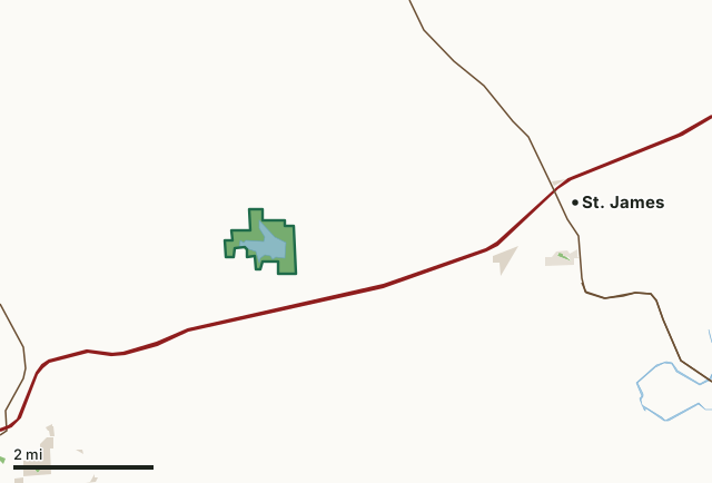
MDC conservation areasCounty, city and regional landLand trusts and other open landLittle Prairie Conservation AreaCounty lineLakeHighway
| Size | 340 acres |
|---|---|
| County | Phelps County |
| Deer harvest unit | Phelps County |
| MDC lists for hunting | Deer, Bear, Turkey, Rabbit, Squirrel, Dove and Quail |
| MDC area number | 6316 |
| MDC region | Ozark |
| Nearest towns | St. James (4 mi), Rolla (5 mi) and Doolittle (11 mi) |
What is Little Prairie Conservation Area like?
The Little Prairie Conservation Area contains the 40 acre remnant Heilbrunn prairie located along the SE corner of the area, and a 3 mile hiking trail that winds through woodlands, restored grasslands, and pollinator plantings. The area has signs to highlight management practices being used to improve habitat for native plant and animal species.
The main attraction of this conservation area is the 97-acre Towell Lake. There are several recreational opportunities here including fishing from the courtesy dock, lakeshore, or from your boat, hunting, and hiking. There are many ongoing aquatic and terrestrial management practices occurring on the area, and any disturbance is only temporary.
In MDC's words, from the Little Prairie Conservation Area page.
What can you hunt on Little Prairie Conservation Area?
MDC's page for Little Prairie Conservation Area lists: Deer: archery only, antlerless permits allowed; Bear: archery only; Turkey: archery and firearms; Rabbit; Squirrel; Dove; Quail.
What are the rules on Little Prairie Conservation Area?
MDC's standard conservation area rules (Chapter 11 of the Wildlife Code) apply; the area's rules on MDC's site list any it adds.
How many deer are taken around Little Prairie Conservation Area?
Little Prairie Conservation Area lies in Phelps County. Hunters checked 2,723 deer in Phelps County in 2025, against 2,384 in 2024.
| County | Little Prairie Conservation Area acres in it | Deer, 2025 | Deer, 2024 | Deer, 2023 |
|---|---|---|---|---|
| Phelps County | 340 | 2,723 | 2,384 | 2,994 |
Harvest for the whole county, not the conservation area alone: MDC deer harvest summaries (2021 to 2025 seasons).
How do you get to Little Prairie Conservation Area?
MDC's directions: From Rolla, take the north outer road of I-44 east about 5 miles, then Route RA north to the area.
Nearest towns: St. James (4 miles), Rolla (5 miles), Doolittle (11 miles) and Newburg (12 miles). Highways within 5 miles: I-44, MO 68, US 63, MO 72 and MO 8.
What other public land is near Little Prairie Conservation Area?
MDC lands within 10 miles:
- Woodson K. Woods Memorial Conservation Area: 5,819 acres, 6.4 miles away
- Marguerite Bray Conservation Area: 129 acres, 8.3 miles away
- Beaver Creek Conservation Area: 147 acres, 9.3 miles away
Public land within 3 miles of Little Prairie Conservation Area
Counting Little Prairie Conservation Area itself, 371 of the 24,687 acres within 3 miles of its boundary are public land open to the public (1.5%), by USGS PAD-US 4.1 and MDC conservation area boundaries.
| Manager | Acres within 3 miles |
|---|---|
| MDC conservation areas | 350 |
| County, city and regional land | 21 |
Questions hunters ask
Where is Little Prairie Conservation Area?
In Phelps County, 4 miles from St. James.
Can you deer hunt on Little Prairie Conservation Area?
Yes, by MDC's page: archery only, antlerless permits allowed.
How much public land is around Little Prairie Conservation Area?
371 acres within 3 miles of its boundary, Little Prairie Conservation Area included, by USGS PAD-US 4.1 and MDC conservation area boundaries. The closest other MDC area is Woodson K. Woods Memorial Conservation Area (6.4 miles).
Get a Missouri hunt plan when they open
Hunt plans for Missouri are coming. Join the list and you'll hear first. The first 50 hunters in each new state get their plan free.
Until then, the free FilledTag app for iPhone has a map that works in every state, Missouri included.
Where these facts come from
- Area description, species, rules and directions: MDC, Little Prairie Conservation Area; MDC conservation area boundaries.
- Boundary and acres: MDC's map layer above. Surrounding public land: USGS PAD-US 4.1 (fee land open to the public) and MDC conservation area boundaries.
- Deer harvest: MDC deer harvest summaries (2021 to 2025 seasons).
FilledTag is not part of the Missouri Department of Conservation. Check MDC's rules and posted signs before you go.