Manito Lake Conservation Area: hunting and access
Manito Lake Conservation Area is 888 acres of MDC land in Moniteau and Morgan counties, next to Fortuna. MDC lists deer hunting here (archery and firearms, antlerless permits allowed). Hunters checked 1,822 deer in Moniteau County in 2025.
Data updated October 2026. Area facts: MDC's conservation area data, read 2026-10. Harvest: MDC deer harvest summaries, 2021 to 2025.
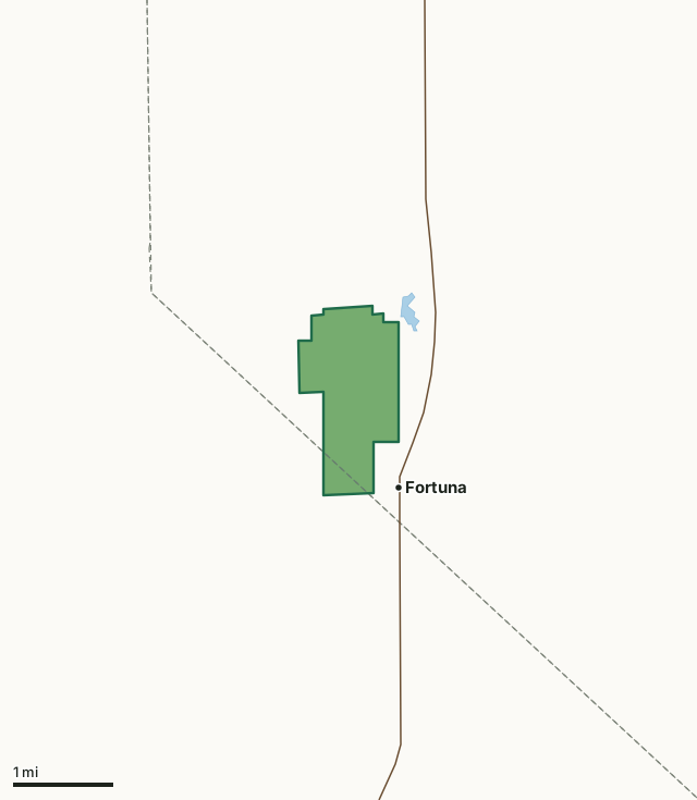
MDC conservation areasManito Lake Conservation AreaCounty lineLakeHighway
| Size | 888 acres |
|---|---|
| Counties | Moniteau County and Morgan County |
| Deer harvest unit | Moniteau County, Morgan County |
| MDC lists for hunting | Deer, Bear, Turkey, Rabbit, Squirrel, Dove and Quail |
| MDC area number | 8101 |
| MDC region | Central |
| Nearest towns | Fortuna (next to it), Tipton (4 mi) and Syracuse (6 mi) |
What is Manito Lake Conservation Area like?
Manito Lake Conservation Area is in western Moniteau County near Fortuna. The area was purchased in 1981 and is 871 acres in size.
The rolling uplands combine a mix of grassland, oldfields, and cropland divided by brushy fencelines and drainages. The area is managed to provide year-round food and cover for upland wildlife. Manito is an American Indian word that means great spirit. Manito is also a variation of the county name, Moniteau.
In MDC's words, from the Manito Lake Conservation Area page.
What can you hunt on Manito Lake Conservation Area?
MDC's page for Manito Lake Conservation Area lists: Deer: archery and firearms, antlerless permits allowed; Bear: archery and firearms; Turkey: archery and firearms; Rabbit; Squirrel; Dove; Quail.
What are the rules on Manito Lake Conservation Area?
MDC's standard conservation area rules (Chapter 11 of the Wildlife Code) apply; the area's rules on MDC's site list any it adds.
How many deer are taken around Manito Lake Conservation Area?
Manito Lake Conservation Area lies in 2 counties. Hunters checked 1,822 deer in Moniteau County in 2025, against 1,693 in 2024.
| County | Manito Lake Conservation Area acres in it | Deer, 2025 | Deer, 2024 | Deer, 2023 |
|---|---|---|---|---|
| Moniteau County | 828 | 1,822 | 1,693 | 1,948 |
| Morgan County | 60 | 3,962 | 3,591 | 4,291 |
Harvest for the whole county, not the conservation area alone: MDC deer harvest summaries (2021 to 2025 seasons).
How do you get to Manito Lake Conservation Area?
MDC's directions: From Tipton, take Highway 5 south 4.50 miles, then East Manito Road west 0.50 mile to the area.
Nearest towns: Fortuna (next to it), Tipton (4 miles), Syracuse (6 miles) and Latham (6 miles). Highways within 5 miles: MO 5 and US 50.
What other public land is near Manito Lake Conservation Area?
MDC lands within 10 miles:
- Lamine River Conservation Area: 6,083 acres, 7.8 miles away
Public land within 3 miles of Manito Lake Conservation Area
Counting Manito Lake Conservation Area itself, 888 of the 28,762 acres within 3 miles of its boundary are public land open to the public (3.1%), by USGS PAD-US 4.1 and MDC conservation area boundaries.
| Manager | Acres within 3 miles |
|---|---|
| MDC conservation areas | 888 |
Questions hunters ask
Where is Manito Lake Conservation Area?
In Moniteau and Morgan counties, next to Fortuna.
Can you deer hunt on Manito Lake Conservation Area?
Yes, by MDC's page: archery and firearms, antlerless permits allowed.
How much public land is around Manito Lake Conservation Area?
888 acres within 3 miles of its boundary, Manito Lake Conservation Area included, by USGS PAD-US 4.1 and MDC conservation area boundaries. The closest other MDC area is Lamine River Conservation Area (7.8 miles).
Get a Missouri hunt plan when they open
Hunt plans for Missouri are coming. Join the list and you'll hear first. The first 50 hunters in each new state get their plan free.
Until then, the free FilledTag app for iPhone has a map that works in every state, Missouri included.
Where these facts come from
- Area description, species, rules and directions: MDC, Manito Lake Conservation Area; MDC conservation area boundaries.
- Boundary and acres: MDC's map layer above. Surrounding public land: USGS PAD-US 4.1 (fee land open to the public) and MDC conservation area boundaries.
- Deer harvest: MDC deer harvest summaries (2021 to 2025 seasons).
FilledTag is not part of the Missouri Department of Conservation. Check MDC's rules and posted signs before you go.