Montgomery Woods Conservation Area: hunting and access
Montgomery Woods Conservation Area is 349 acres of MDC land in Adair and Macon counties, 3 miles from Winigan. MDC lists deer hunting here (archery and firearms, antlerless permits allowed). Hunters checked 2,639 deer in Adair County in 2025.
Data updated October 2026. Area facts: MDC's conservation area data, read 2026-10. Harvest: MDC deer harvest summaries, 2021 to 2025.
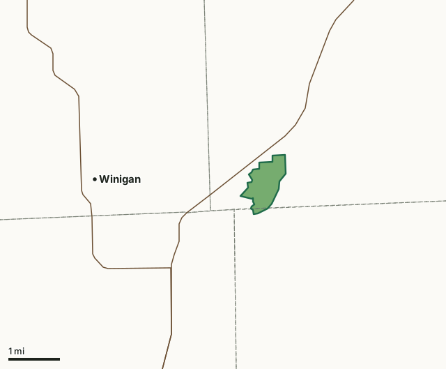
MDC conservation areasMontgomery Woods Conservation AreaCounty lineHighway
| Size | 349 acres |
|---|---|
| Counties | Adair County and Macon County |
| Deer harvest unit | Adair County, Macon County |
| MDC lists for hunting | Deer, Turkey and Squirrel |
| MDC area number | 7725 |
| MDC region | Northeast |
| Camping (MDC) | walk-in, float-in or backpack camping (not during deer and turkey seasons) and designated camping sites |
| Nearest towns | Winigan (3 mi), South Gifford (8 mi) and Ethel (11 mi) |
What is Montgomery Woods Conservation Area like?
All of Montgomery Woods Conservation Area is forested. Visitors will find a challenge on the rough terrain of this 348-acre area. Oak-hickory forest covers the steep hills and ridgetops. Bottomland tree species include silver maple, cottonwood, sycamore, and an assortment of other hardwoods.
During your visit to Montgomery Woods Conservation Area, you may view various forest management practices such as tree improvement and tree harvest to create forest openings for wildlife, promote a healthy forest, and ensure a diversity of tree sizes and age classes. White-tailed deer and wild turkey are abundant on the area as well as numerous songbirds.
In MDC's words, from the Montgomery Woods Conservation Area page.
What can you hunt on Montgomery Woods Conservation Area?
MDC's page for Montgomery Woods Conservation Area lists: Deer: archery and firearms, antlerless permits allowed; Turkey: archery and firearms; Squirrel.
What are the rules on Montgomery Woods Conservation Area?
MDC's standard conservation area rules (Chapter 11 of the Wildlife Code) apply; the area's rules on MDC's site list any it adds.
How many deer are taken around Montgomery Woods Conservation Area?
Montgomery Woods Conservation Area lies in 2 counties. Hunters checked 2,639 deer in Adair County in 2025, against 2,827 in 2024.
| County | Montgomery Woods Conservation Area acres in it | Deer, 2025 | Deer, 2024 | Deer, 2023 |
|---|---|---|---|---|
| Adair County | 337 | 2,639 | 2,827 | 2,823 |
| Macon County | 12 | 4,525 | 4,489 | 4,746 |
Harvest for the whole county, not the conservation area alone: MDC deer harvest summaries (2021 to 2025 seasons).
How do you get to Montgomery Woods Conservation Area?
MDC's directions: From Kirksville, take Highway 11 west 18 miles, then take Montgomery Woods Trail south 0.75 mile to the area.
Nearest towns: Winigan (3 miles), South Gifford (8 miles), Ethel (11 miles) and Elmer (11 miles). Highways within 5 miles: MO 11, MO 129 and MO 149.
What other public land is near Montgomery Woods Conservation Area?
MDC lands within 10 miles:
- Sugar Creek Conservation Area: 2,589 acres, 9.2 miles away
- Hidden Hollow Conservation Area: 1,332 acres, 9.6 miles away
Public land within 3 miles of Montgomery Woods Conservation Area
Counting Montgomery Woods Conservation Area itself, 350 of the 24,505 acres within 3 miles of its boundary are public land open to the public (1.4%), by USGS PAD-US 4.1 and MDC conservation area boundaries.
| Manager | Acres within 3 miles |
|---|---|
| MDC conservation areas | 350 |
Questions hunters ask
Where is Montgomery Woods Conservation Area?
In Adair and Macon counties, 3 miles from Winigan.
Can you deer hunt on Montgomery Woods Conservation Area?
Yes, by MDC's page: archery and firearms, antlerless permits allowed.
How much public land is around Montgomery Woods Conservation Area?
350 acres within 3 miles of its boundary, Montgomery Woods Conservation Area included, by USGS PAD-US 4.1 and MDC conservation area boundaries. The closest other MDC area is Sugar Creek Conservation Area (9.2 miles).
Get a Missouri hunt plan when they open
Hunt plans for Missouri are coming. Join the list and you'll hear first. The first 50 hunters in each new state get their plan free.
Until then, the free FilledTag app for iPhone has a map that works in every state, Missouri included.
Where these facts come from
- Area description, species, rules and directions: MDC, Montgomery Woods Conservation Area; MDC conservation area boundaries.
- Boundary and acres: MDC's map layer above. Surrounding public land: USGS PAD-US 4.1 (fee land open to the public) and MDC conservation area boundaries.
- Deer harvest: MDC deer harvest summaries (2021 to 2025 seasons).
FilledTag is not part of the Missouri Department of Conservation. Check MDC's rules and posted signs before you go.