Niangua Conservation Area: hunting and access
Niangua Conservation Area is 855 acres of MDC land in Webster County, next to Niangua. MDC lists deer hunting here (archery and firearms, antlerless permits allowed). Hunters checked 2,914 deer in Webster County in 2025.
Data updated October 2026. Area facts: MDC's conservation area data, read 2026-10. Harvest: MDC deer harvest summaries, 2021 to 2025.
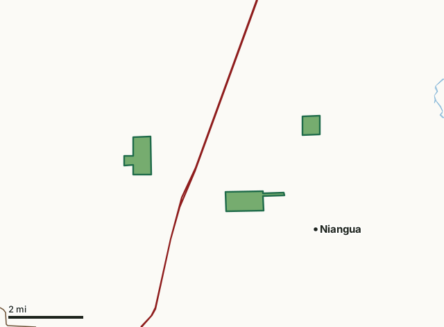
MDC conservation areasNiangua Conservation AreaCounty lineLakeHighway
| Size | 855 acres in 3 pieces |
|---|---|
| County | Webster County |
| Deer harvest unit | Webster County |
| MDC lists for hunting | Deer, Bear, Turkey, Rabbit and Squirrel |
| MDC area number | 6514 |
| MDC region | Southwest |
| Camping (MDC) | open camping - walk-in/float-in/backpack |
| Nearest towns | Niangua (next to it), Marshfield (4 mi) and Conway (5 mi) |
What is Niangua Conservation Area like?
Niangua Conservation Area is located in Webster County, approximately 30 miles east of Springfield and five miles northeast of Marshfield. The area is comprised of three separate tracts, known as the St. Luke tract, the Sampson tract, and the Niangua tract.
For many years, the Niangua tract was landlocked and there was no public access. The Missouri Department of Conservation recently purchased a parcel that provides public access from Highway CC. This opened the Niangua tract to public use, but there is currently no parking lot available.
In MDC's words, from the Niangua Conservation Area page.
What can you hunt on Niangua Conservation Area?
MDC's page for Niangua Conservation Area lists: Deer: archery and firearms, antlerless permits allowed; Bear: archery and firearms; Turkey: archery and firearms; Rabbit; Squirrel.
What are the rules on Niangua Conservation Area?
MDC's standard conservation area rules (Chapter 11 of the Wildlife Code) apply; the area's rules on MDC's site list any it adds.
How many deer are taken around Niangua Conservation Area?
Niangua Conservation Area lies in Webster County. Hunters checked 2,914 deer in Webster County in 2025, against 2,646 in 2024.
| County | Niangua Conservation Area acres in it | Deer, 2025 | Deer, 2024 | Deer, 2023 |
|---|---|---|---|---|
| Webster County | 855 | 2,914 | 2,646 | 3,344 |
Harvest for the whole county, not the conservation area alone: MDC deer harvest summaries (2021 to 2025 seasons).
How do you get to Niangua Conservation Area?
MDC's directions: To access the 360 acre St. Luke Tract: From I-44 at Marshfield, take the Highway 38 and Route W exit west to the Outer Road on the west side of I-44 and go north to Brinkley Road. Follow Brinkley Road and bear left on Black Horse Road where it forms a "Y"-intersection. The Conservation area is almost 0.50 mile on the left on Black Horse Road.
Nearest towns: Niangua (next to it), Marshfield (4 miles), Conway (5 miles) and Phillipsburg (9 miles). Highways within 5 miles: I-44 and MO 38.
What other public land is near Niangua Conservation Area?
MDC lands within 10 miles:
- Rader Access: 67 acres, 5.4 miles away
- Goose Creek Conservation Area: 882 acres, 6.9 miles away
- Charity Access: 145 acres, 7.1 miles away
- John Alva Fuson, MD Conservation Area: 1,517 acres, 9.8 miles away
Public land within 3 miles of Niangua Conservation Area
Counting Niangua Conservation Area itself, 857 of the 47,748 acres within 3 miles of its boundary are public land open to the public (1.8%), by USGS PAD-US 4.1 and MDC conservation area boundaries.
| Manager | Acres within 3 miles |
|---|---|
| MDC conservation areas | 857 |
Questions hunters ask
Where is Niangua Conservation Area?
In Webster County, next to Niangua.
Can you deer hunt on Niangua Conservation Area?
Yes, by MDC's page: archery and firearms, antlerless permits allowed.
How much public land is around Niangua Conservation Area?
857 acres within 3 miles of its boundary, Niangua Conservation Area included, by USGS PAD-US 4.1 and MDC conservation area boundaries. The closest other MDC area is Rader Access (5.4 miles).
Get a Missouri hunt plan when they open
Hunt plans for Missouri are coming. Join the list and you'll hear first. The first 50 hunters in each new state get their plan free.
Until then, the free FilledTag app for iPhone has a map that works in every state, Missouri included.
Where these facts come from
- Area description, species, rules and directions: MDC, Niangua Conservation Area; MDC conservation area boundaries.
- Boundary and acres: MDC's map layer above. Surrounding public land: USGS PAD-US 4.1 (fee land open to the public) and MDC conservation area boundaries.
- Deer harvest: MDC deer harvest summaries (2021 to 2025 seasons).
FilledTag is not part of the Missouri Department of Conservation. Check MDC's rules and posted signs before you go.