Norfork Lake Management Lands: hunting and access
Norfork Lake Management Lands is 4,972 acres of MDC land in Ozark County, 5 miles from Bakersfield. MDC lists deer hunting here (archery and firearms, antlerless permits allowed). Hunters checked 2,819 deer in Ozark County in 2025.
Data updated October 2026. Area facts: MDC's conservation area data, read 2026-10. Harvest: MDC deer harvest summaries, 2021 to 2025.
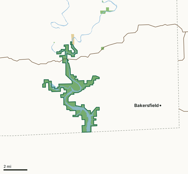
MDC conservation areasFederal land, mostly Corps of Engineers lakesNorfork Lake Management LandsCounty lineLakeHighway
| Size | 4,972 acres |
|---|---|
| County | Ozark County |
| Deer harvest unit | Ozark County |
| MDC lists for hunting | Deer, Bear, Turkey, Rabbit, Squirrel, Dove and Quail |
| MDC area number | 8918 |
| MDC region | Ozark |
| Nearest towns | Bakersfield (5 mi), Gainesville (6 mi) and Pontiac (16 mi) |
What is Norfork Lake Management Lands like?
This area is owned by the US Army Corps of Engineers and managed by the Missouri Department of Conservation (MDC) through a long term habitat lease. The reservoir itself is fed largely by Bryant Creek and the North Fork of the White River with both joining at the confluence just above the Hwy 160 bridge in Tecumseh. Many other feeder streams feed into the lake as well including Cane Creek, Lick Creek, Liner Creek, Bridges Creek, among others. The Norfork fishery is managed jointly by biologists from MDC and Arkansas Game and Fish. The terrestrial habitat in Missouri is managed by MDC biologists for small game, deer, and turkey using native grass plantings and annual grain plots interspersed among the forests and old fields that make up the areas along the lake.
In MDC's words, from the Norfork Lake Management Lands page.
What can you hunt on Norfork Lake Management Lands?
MDC's page for Norfork Lake Management Lands lists: Deer: archery and firearms, antlerless permits allowed; Bear: archery and firearms; Turkey: archery and firearms; Rabbit; Squirrel; Dove; Quail.
What are the rules on Norfork Lake Management Lands?
MDC's standard conservation area rules (Chapter 11 of the Wildlife Code) apply; the area's rules on MDC's site list any it adds.
How many deer are taken around Norfork Lake Management Lands?
Norfork Lake Management Lands lies in Ozark County. Hunters checked 2,819 deer in Ozark County in 2025, against 2,633 in 2024.
| County | Norfork Lake Management Lands acres in it | Deer, 2025 | Deer, 2024 | Deer, 2023 |
|---|---|---|---|---|
| Ozark County | 4,968 | 2,819 | 2,633 | 3,257 |
Harvest for the whole county, not the conservation area alone: MDC deer harvest summaries (2021 to 2025 seasons).
How do you get to Norfork Lake Management Lands?
MDC's directions: Norfork Lake is about 20 miles SW of West Plains and 9 miles SE of Gainesville, and can be reached from Route O, Route T, or Highway 160.
Nearest towns: Bakersfield (5 miles), Gainesville (6 miles), Pontiac (16 miles) and South Fork (16 miles). Highways within 5 miles: US 160.
What other public land is near Norfork Lake Management Lands?
MDC lands within 10 miles:
- Patrick Bridge Access: 149 acres, 3.4 miles away
- Caney Mountain Conservation Area: 7,977 acres, 7.2 miles away
Public land within 3 miles of Norfork Lake Management Lands
Counting Norfork Lake Management Lands itself, 5,156 of the 68,521 acres within 3 miles of its boundary are public land open to the public (7.5%), by USGS PAD-US 4.1 and MDC conservation area boundaries.
| Manager | Acres within 3 miles |
|---|---|
| MDC conservation areas | 5,015 |
| Federal land, mostly Corps of Engineers lakes | 141 |
Questions hunters ask
Where is Norfork Lake Management Lands?
In Ozark County, 5 miles from Bakersfield.
Can you deer hunt on Norfork Lake Management Lands?
Yes, by MDC's page: archery and firearms, antlerless permits allowed.
How much public land is around Norfork Lake Management Lands?
5,156 acres within 3 miles of its boundary, Norfork Lake Management Lands included, by USGS PAD-US 4.1 and MDC conservation area boundaries. The closest other MDC area is Patrick Bridge Access (3.4 miles).
Get a Missouri hunt plan when they open
Hunt plans for Missouri are coming. Join the list and you'll hear first. The first 50 hunters in each new state get their plan free.
Until then, the free FilledTag app for iPhone has a map that works in every state, Missouri included.
Where these facts come from
- Area description, species, rules and directions: MDC, Norfork Lake Management Lands; MDC conservation area boundaries.
- Boundary and acres: MDC's map layer above. Surrounding public land: USGS PAD-US 4.1 (fee land open to the public) and MDC conservation area boundaries.
- Deer harvest: MDC deer harvest summaries (2021 to 2025 seasons).
FilledTag is not part of the Missouri Department of Conservation. Check MDC's rules and posted signs before you go.