Pilot Knob Conservation Area: hunting and access
Pilot Knob Conservation Area is 1,370 acres of MDC land in Stone County, 3 miles from Arrow Point. MDC lists deer hunting here (archery and firearms, antlerless permits allowed). Hunters checked 2,137 deer in Stone County in 2025.
Data updated October 2026. Area facts: MDC's conservation area data, read 2026-10. Harvest: MDC deer harvest summaries, 2021 to 2025.
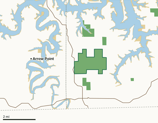
MDC conservation areasNational forestFederal land, mostly Corps of Engineers lakesPilot Knob Conservation AreaCounty lineLakeHighway
| Size | 1,370 acres |
|---|---|
| County | Stone County |
| Deer harvest unit | Stone County |
| MDC lists for hunting | Deer, Bear, Turkey, Rabbit and Squirrel |
| MDC area number | 9909 |
| MDC region | Southwest |
| Nearest towns | Arrow Point (3 mi), Shell Knob (4 mi) and Golden (5 mi) |
What is Pilot Knob Conservation Area like?
Pilot Knob Conservation Area has a 6.6-mile out and back trail (slightly more than three miles one way) that is good for nature-viewing and nature photography. It's a good option for those looking for an off-the-beaten path hike. Hunting is allowed. Habitat consists of large contiguous tracts of woodlands and glades. The term "pilot knob" comes from the use of the tall hilltops in the Ozarks as reference and triangulation points. The tops of these hills were often cleared of all but one tree. This "signal tree" designated the hilltop as a pilot knob. Several pilot knobs existed across southern Missouri in the early 1900s. Pilot Knob Conservation Area contained one of them.
In MDC's words, from the Pilot Knob Conservation Area page.
What can you hunt on Pilot Knob Conservation Area?
MDC's page for Pilot Knob Conservation Area lists: Deer: archery and firearms, antlerless permits allowed; Bear: archery and firearms; Turkey: archery and firearms; Rabbit; Squirrel.
What are the rules on Pilot Knob Conservation Area?
MDC's standard conservation area rules (Chapter 11 of the Wildlife Code) apply; the area's rules on MDC's site list any it adds.
How many deer are taken around Pilot Knob Conservation Area?
Pilot Knob Conservation Area lies in Stone County. Hunters checked 2,137 deer in Stone County in 2025, against 1,878 in 2024.
| County | Pilot Knob Conservation Area acres in it | Deer, 2025 | Deer, 2024 | Deer, 2023 |
|---|---|---|---|---|
| Stone County | 1,370 | 2,137 | 1,878 | 2,387 |
Harvest for the whole county, not the conservation area alone: MDC deer harvest summaries (2021 to 2025 seasons).
How do you get to Pilot Knob Conservation Area?
MDC's directions: From Carr Lane, take Highway 39 north 2.60 miles to parking area on the east, or right side of the road.
Nearest towns: Arrow Point (3 miles), Shell Knob (4 miles), Golden (5 miles) and Emerald Beach (6 miles). Highways within 5 miles: MO 86 and MO 39.
What other public land is near Pilot Knob Conservation Area?
Public land within 3 miles of Pilot Knob Conservation Area
Counting Pilot Knob Conservation Area itself, 8,796 of the 31,952 acres within 3 miles of its boundary are public land open to the public (27.5%), by USGS PAD-US 4.1 and MDC conservation area boundaries.
| Manager | Acres within 3 miles |
|---|---|
| Federal land, mostly Corps of Engineers lakes | 6,877 |
| MDC conservation areas | 1,378 |
| National forest | 541 |
Questions hunters ask
Where is Pilot Knob Conservation Area?
In Stone County, 3 miles from Arrow Point.
Can you deer hunt on Pilot Knob Conservation Area?
Yes, by MDC's page: archery and firearms, antlerless permits allowed.
How much public land is around Pilot Knob Conservation Area?
8,796 acres within 3 miles of its boundary, Pilot Knob Conservation Area included, by USGS PAD-US 4.1 and MDC conservation area boundaries.
Get a Missouri hunt plan when they open
Hunt plans for Missouri are coming. Join the list and you'll hear first. The first 50 hunters in each new state get their plan free.
Until then, the free FilledTag app for iPhone has a map that works in every state, Missouri included.
Where these facts come from
- Area description, species, rules and directions: MDC, Pilot Knob Conservation Area; MDC conservation area boundaries.
- Boundary and acres: MDC's map layer above. Surrounding public land: USGS PAD-US 4.1 (fee land open to the public) and MDC conservation area boundaries.
- Deer harvest: MDC deer harvest summaries (2021 to 2025 seasons).
FilledTag is not part of the Missouri Department of Conservation. Check MDC's rules and posted signs before you go.