Poosey Conservation Area: hunting and access
Poosey Conservation Area is 5,796 acres of MDC land in Livingston and Grundy counties, 4 miles from Jamesport. MDC lists deer hunting here (archery and firearms, antlerless permits not allowed). Hunters checked 2,120 deer in Livingston County in 2025.
Data updated October 2026. Area facts: MDC's conservation area data, read 2026-10. Harvest: MDC deer harvest summaries, 2021 to 2025.
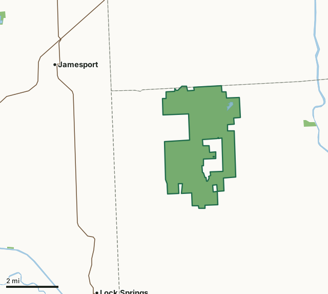
MDC conservation areasPoosey Conservation AreaCounty lineLakeHighway
| Size | 5,796 acres |
|---|---|
| Counties | Livingston County and Grundy County |
| Deer harvest unit | Livingston County, Grundy County |
| MDC lists for hunting | Deer, Turkey, Rabbit, Squirrel, Dove and Quail |
| MDC area number | 7935 |
| MDC region | Northwest |
| Camping (MDC) | designated camping sites |
| Shooting range (MDC) | rifle or pistol |
| Nearest towns | Jamesport (4 mi), Lock Springs (5 mi) and Edinburg (8 mi) |
What is Poosey Conservation Area like?
Poosey Conservation Area is in northwest Livingston County, six miles southeast of Jamesport, nine miles northeast of Lock Springs, 12 miles southwest of Trenton and 13 miles northwest of Chillicothe. The Conservation Department purchased the original 814-acre tract for Poosey Conservation Area in 1979 from Robert Daugherty. Additional purchases have increased the area to its current size. The area contains unique fern-draped rock bluffs, heavily timbered hills of oak and hickory, rolling grass expanses, and a variety of wildlife. The foliage provides brilliant and showy fall colors. This portion of the Grand River Valley was one of the last parts of Missouri yielded by the American Indians. In 1833, the last remnants of the Shawnee tribe left the area, opening the area to settlement by people of European extraction, who came here via Kentucky, Tennessee, and Virginia. The settlers, who preferred forested tracts to open prairies, were attracted by plentiful natural supplies of food, fuel, water, and building materials. The area's rugged landscape reminded some of the settlers of the Poosey region in Kentucky, giving rise to the areas name. The area continues to be known as the Kingdom of Poosey, and travelers asking directions to it are usually informed that it is just ahead over the next hill. With its combination of hardwood forests and tallgrass prairie, the area supports a thriving plant and animal community. Deer, turkey, raccoons, squirrels, quail, rabbits, coyotes, foxes, and many other small animals and birds are commonly seen here. Nestled among the steep, tree-covered hills in the southern portion of Poosey Conservation Area is 192-acre Indian Creek Community Lake, which was constructed in 1987. The lake features a disabled-accessible floating fishing dock. The area also contains a shooting range, which features 25-, 50- and 100-yard firearms targets. The range is located in the northwest portion of the area.
Area closed to bicycle use (and horseback riding) during all portions of the firearms deer hunting season and spring turkey hunting seasons.
In MDC's words, from the Poosey Conservation Area page.
What can you hunt on Poosey Conservation Area?
MDC's page for Poosey Conservation Area lists: Deer: archery and firearms, antlerless permits not allowed; Turkey: archery and firearms; Rabbit; Squirrel; Dove; Quail.
What are the rules on Poosey Conservation Area?
Target Shooting and Shooting Ranges: An unstaffed range is located on this department area. Target shooting is not allowed anywhere on this area except for designated shooting range(s). Shooting hours are one-half hour before sunrise to one-half hour after sunset. Ranges may be closed to public use at any time for maintenance or department sponsored events or programs. Possession of alcoholic beverages is prohibited on all ranges and associated parking lots. Groups of more than 10 people must obtain a special use permit prior to using the range. To obtain a special use permit, contact the area manager at the phone number listed...
Every conservation area also follows MDC's standard rules in Chapter 11 of the Wildlife Code; the area's full rules are on MDC's site.
How many deer are taken around Poosey Conservation Area?
Poosey Conservation Area lies in 2 counties. Hunters checked 2,120 deer in Livingston County in 2025, against 1,990 in 2024.
| County | Poosey Conservation Area acres in it | Deer, 2025 | Deer, 2024 | Deer, 2023 |
|---|---|---|---|---|
| Livingston County | 5,785 | 2,120 | 1,990 | 2,153 |
| Grundy County | 11 | 1,812 | 1,885 | 1,856 |
Harvest for the whole county, not the conservation area alone: MDC deer harvest summaries (2021 to 2025 seasons).
How do you get to Poosey Conservation Area?
MDC's directions: From Chillicothe, take Highway 190 west 5 miles, then Route A north 5 miles. At the Route W junction, continue on Route A west 1 mile to the area entrance.
Nearest towns: Jamesport (4 miles), Lock Springs (5 miles), Edinburg (8 miles) and Trenton (9 miles). Highways within 5 miles: MO 190 and MO 6.
What other public land is near Poosey Conservation Area?
MDC lands within 10 miles:
- Punkin Center Access: 54 acres, 2.4 miles away
- Jamesport Community Lake: 142 acres, 6.8 miles away
- Mockingbird Hill Access: 84 acres, 8.2 miles away
Public land within 3 miles of Poosey Conservation Area
Counting Poosey Conservation Area itself, 5,851 of the 51,210 acres within 3 miles of its boundary are public land open to the public (11.4%), by USGS PAD-US 4.1 and MDC conservation area boundaries.
| Manager | Acres within 3 miles |
|---|---|
| MDC conservation areas | 5,851 |
Questions hunters ask
Where is Poosey Conservation Area?
In Livingston and Grundy counties, 4 miles from Jamesport.
Can you deer hunt on Poosey Conservation Area?
Yes, by MDC's page: archery and firearms, antlerless permits not allowed.
How much public land is around Poosey Conservation Area?
5,851 acres within 3 miles of its boundary, Poosey Conservation Area included, by USGS PAD-US 4.1 and MDC conservation area boundaries. The closest other MDC area is Punkin Center Access (2.4 miles).
Get a Missouri hunt plan when they open
Hunt plans for Missouri are coming. Join the list and you'll hear first. The first 50 hunters in each new state get their plan free.
Until then, the free FilledTag app for iPhone has a map that works in every state, Missouri included.
Where these facts come from
- Area description, species, rules and directions: MDC, Poosey Conservation Area; MDC conservation area boundaries.
- Boundary and acres: MDC's map layer above. Surrounding public land: USGS PAD-US 4.1 (fee land open to the public) and MDC conservation area boundaries.
- Deer harvest: MDC deer harvest summaries (2021 to 2025 seasons).
FilledTag is not part of the Missouri Department of Conservation. Check MDC's rules and posted signs before you go.