Poplar Bluff Conservation Area: hunting and access
Poplar Bluff Conservation Area is 1,118 acres of MDC land in Butler County, 3 miles from Poplar Bluff. MDC lists deer hunting here (archery and firearms, archery antlerless permits only). Hunters checked 1,852 deer in Butler County in 2025.
Data updated October 2026. Area facts: MDC's conservation area data, read 2026-10. Harvest: MDC deer harvest summaries, 2021 to 2025.
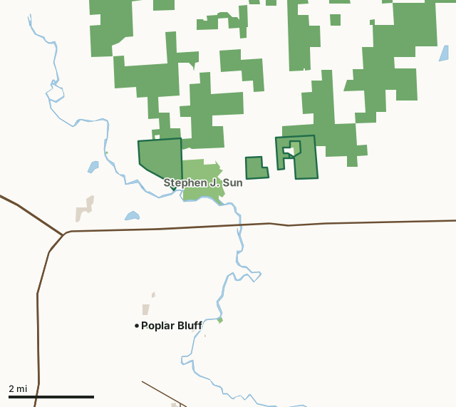
MDC conservation areasNational forestCounty, city and regional landPoplar Bluff Conservation AreaCounty lineLakeHighway
| Size | 1,118 acres in 3 pieces |
|---|---|
| County | Butler County |
| Deer harvest unit | Butler County |
| MDC lists for hunting | Deer, Bear, Turkey, Rabbit, Squirrel, Dove and Quail |
| MDC area number | 6529 |
| MDC region | Southeast |
| Camping (MDC) | open camping - walk-in/float-in/backpack |
| Shooting range (MDC) | archery |
| Nearest towns | Poplar Bluff (3 mi), Fisk (7 mi) and Broseley (11 mi) |
What is Poplar Bluff Conservation Area like?
Poplar Bluff and Stephen J. Sun Conservation Areas are located in Butler County,two miles east of Poplar Bluff on U.S. Business 60, then 3.50 miles north onRoute NN. Turn left on County Road 544 and follow itone mile west to the area parking lot. Thesetwo conservation areas comprise 1,591 acres in five tracts and include six-acre Carpenter Lake and the 80-acre Poplar Bluff Forest Natural Area. The University of Missouri acquired what is now Poplar Bluff Conservation Area under the Agriculture College Act of 1862. The Conservation Department purchased this tract from the University in 1965. An additional 240 acres was purchased in 1995.
Stephen J. Sun Conservation Area consists of 485 acres. The Department acquired parts of this conservation area in 1988, thanks to a donation by the Sun family. Department funds were used to purchase the remainder of the lands. These two conservation areas represent a unique contact zone of two major ecosystems- the Ozark highland and the coastal plain wetland. The hills of Poplar Bluff Conservation Area have soils of primarily Clarksville or Loring silt loams. The soils covering the fields of Stephen J. Sun Conservation Area are mainly Elk, Adler, and Calhoun silt loams. Upland tree species include hickory and black, white, and scarlet oak. Cherrybark oak, sweetgum, red maple, and sugarberry are the primary bottomland species. Several endangered species and unusual plants inhabit both areas. On Stephen J. Sun Conservation Area both river otter and swamp rabbits have been observed. The...
In MDC's words, from the Poplar Bluff Conservation Area page.
What can you hunt on Poplar Bluff Conservation Area?
MDC's page for Poplar Bluff Conservation Area lists: Deer: archery and firearms, archery antlerless permits only; Bear: archery and firearms; Turkey: archery and firearms; Rabbit; Squirrel; Dove; Quail.
What are the rules on Poplar Bluff Conservation Area?
Target Shooting and Shooting Ranges: An unstaffed range is located on this department area. Target shooting is not allowed anywhere on this area except for designated shooting range(s). Shooting hours are one-half hour before sunrise to one-half hour after sunset. Ranges may be closed to public use at any time for maintenance or department sponsored events or programs. Possession of alcoholic beverages is prohibited on all ranges and associated parking lots. Groups of more than 10 people must obtain a special use permit prior to using the range. To obtain a special use permit, contact the area manager at the phone number listed...
Every conservation area also follows MDC's standard rules in Chapter 11 of the Wildlife Code; the area's full rules are on MDC's site.
How many deer are taken around Poplar Bluff Conservation Area?
Poplar Bluff Conservation Area lies in Butler County. Hunters checked 1,852 deer in Butler County in 2025, against 1,490 in 2024.
| County | Poplar Bluff Conservation Area acres in it | Deer, 2025 | Deer, 2024 | Deer, 2023 |
|---|---|---|---|---|
| Butler County | 1,118 | 1,852 | 1,490 | 2,045 |
Harvest for the whole county, not the conservation area alone: MDC deer harvest summaries (2021 to 2025 seasons).
How do you get to Poplar Bluff Conservation Area?
MDC's directions: From Poplar Bluff, take Highway 60 east 6.0 miles, then exit and turn left onto Route T and head north for 2.4 miles. Turn left onto County Road 553 and head west for 1.1 miles to the area.
Nearest towns: Poplar Bluff (3 miles), Fisk (7 miles), Broseley (11 miles) and Harviell (12 miles). Highways within 5 miles: US 60, US 67, US 160 and MO 53.
What other public land is near Poplar Bluff Conservation Area?
MDC lands within 10 miles:
- Stephen J. Sun Conservation Area: 505 acres, next to it
- University Forest Conservation Area: 7,158 acres, 4 miles away
- Dan River Access: 79 acres, 7.3 miles away
Public land within 3 miles of Poplar Bluff Conservation Area
Counting Poplar Bluff Conservation Area itself, 7,797 of the 39,843 acres within 3 miles of its boundary are public land open to the public (19.6%), by USGS PAD-US 4.1 and MDC conservation area boundaries.
| Manager | Acres within 3 miles |
|---|---|
| National forest | 6,011 |
| MDC conservation areas | 1,690 |
| County, city and regional land | 96 |
Questions hunters ask
Where is Poplar Bluff Conservation Area?
In Butler County, 3 miles from Poplar Bluff.
Can you deer hunt on Poplar Bluff Conservation Area?
Yes, by MDC's page: archery and firearms, archery antlerless permits only.
How much public land is around Poplar Bluff Conservation Area?
7,797 acres within 3 miles of its boundary, Poplar Bluff Conservation Area included, by USGS PAD-US 4.1 and MDC conservation area boundaries. The closest other MDC area is Stephen J. Sun Conservation Area (next to it).
Get a Missouri hunt plan when they open
Hunt plans for Missouri are coming. Join the list and you'll hear first. The first 50 hunters in each new state get their plan free.
Until then, the free FilledTag app for iPhone has a map that works in every state, Missouri included.
Where these facts come from
- Area description, species, rules and directions: MDC, Poplar Bluff Conservation Area; MDC conservation area boundaries.
- Boundary and acres: MDC's map layer above. Surrounding public land: USGS PAD-US 4.1 (fee land open to the public) and MDC conservation area boundaries.
- Deer harvest: MDC deer harvest summaries (2021 to 2025 seasons).
FilledTag is not part of the Missouri Department of Conservation. Check MDC's rules and posted signs before you go.