Saint Stanislaus Conservation Area: hunting and access
Saint Stanislaus Conservation Area is 877 acres of MDC land in St. Louis County, next to Hazelwood. MDC lists deer hunting here (archery only, antlerless permits allowed). Hunters checked 1,922 deer in St. Louis County in 2025.
Data updated October 2026. Area facts: MDC's conservation area data, read 2026-10. Harvest: MDC deer harvest summaries, 2021 to 2025.
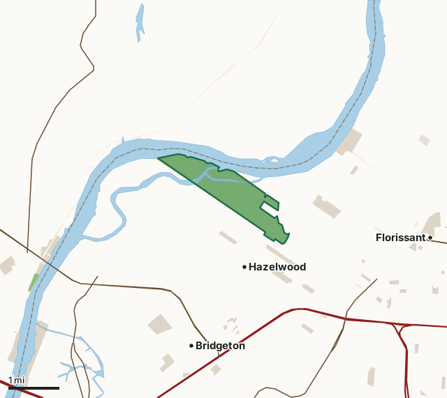
MDC conservation areasState parks and historic sitesOther state landCounty, city and regional landLand trusts and other open landSaint Stanislaus Conservation AreaCounty lineLakeHighway
| Size | 877 acres (812 by MDC's page) |
|---|---|
| County | St. Louis County |
| Deer harvest unit | St. Louis County |
| MDC lists for hunting | Deer |
| MDC area number | 9127 |
| MDC region | St. Louis |
| MDC managed hunts | turkey |
| Nearest towns | Hazelwood (next to it), Bridgeton (3 mi) and Florissant (3 mi) |
What is Saint Stanislaus Conservation Area like?
Saint Stanislaus is a conservation area steeped in nature and history. Located within easy reach of residential areas in north St. Louis County, the area was named for the former Saint Stanislaus Seminary which used this site for a retreat. History buffs can spot old building foundations from this retreat on the trail that climbs historic Charbonier Bluff. Early French explorers named this bluff La Charbonier, which means coal seam. The journals of Lewis and Clark also noted its coal resources.
Hikers willing to tackle the steep trail up the bluff will also be rewarded with an expansive view overlooking the Missouri River bottoms. The trail also crosses a curious expansion bridge, and other portions are paved and disabled-accessible. An alternate level and linear trail conveys hikers through the rich bottomlands of the area and to the Bryan Island Chute, which flows out to the Missouri River.
In MDC's words, from the Saint Stanislaus Conservation Area page.
What can you hunt on Saint Stanislaus Conservation Area?
MDC's page for Saint Stanislaus Conservation Area lists: Deer: archery only, antlerless permits allowed. It also lists managed hunts for turkey; MDC's managed deer hunt list has the dates and how to apply.
What are the rules on Saint Stanislaus Conservation Area?
MDC's standard conservation area rules (Chapter 11 of the Wildlife Code) apply; the area's rules on MDC's site list any it adds.
How many deer are taken around Saint Stanislaus Conservation Area?
Saint Stanislaus Conservation Area lies in St. Louis County. Hunters checked 1,922 deer in St. Louis County in 2025, against 1,917 in 2024.
| County | Saint Stanislaus Conservation Area acres in it | Deer, 2025 | Deer, 2024 | Deer, 2023 |
|---|---|---|---|---|
| St. Louis County | 877 | 1,922 | 1,917 | 2,015 |
Harvest for the whole county, not the conservation area alone: MDC deer harvest summaries (2021 to 2025 seasons).
How do you get to Saint Stanislaus Conservation Area?
MDC's directions: In Hazelwood, take Highway 370 to Exit #9 (Earth City Expressway/Hwy 141). Travel north on Missouri Bottom Road. Stay straight on Aubuchon Road at the junction with Missouri Bottom Road (Missouri Bottom road turns east). Go 2.4 miles north to Area entrance.
Nearest towns: Hazelwood (next to it), Bridgeton (3 miles), Florissant (3 miles) and Calverton Park (4 miles). Highways within 5 miles: I-270, MO 370, I-70, US 67 and MO 94.
What other public land is near Saint Stanislaus Conservation Area?
MDC lands within 10 miles:
- Blanchette Landing Access: 21 acres, 3.3 miles away
- Marais Temps Clair Conservation Area: 948 acres, 3.9 miles away
- Pelican Island Natural Area: 2,570 acres, 4.7 miles away
Public land within 3 miles of Saint Stanislaus Conservation Area
Counting Saint Stanislaus Conservation Area itself, 1,503 of the 31,561 acres within 3 miles of its boundary are public land open to the public (4.8%), by USGS PAD-US 4.1 and MDC conservation area boundaries.
| Manager | Acres within 3 miles |
|---|---|
| MDC conservation areas | 877 |
| County, city and regional land | 577 |
| Other state land | 42 |
| State parks and historic sites | 5 |
| Land trusts and other open land | 2 |
Questions hunters ask
Where is Saint Stanislaus Conservation Area?
In St. Louis County, next to Hazelwood.
Can you deer hunt on Saint Stanislaus Conservation Area?
Yes, by MDC's page: archery only, antlerless permits allowed.
How much public land is around Saint Stanislaus Conservation Area?
1,503 acres within 3 miles of its boundary, Saint Stanislaus Conservation Area included, by USGS PAD-US 4.1 and MDC conservation area boundaries. The closest other MDC area is Blanchette Landing Access (3.3 miles).
Get a Missouri hunt plan when they open
Hunt plans for Missouri are coming. Join the list and you'll hear first. The first 50 hunters in each new state get their plan free.
Until then, the free FilledTag app for iPhone has a map that works in every state, Missouri included.
Where these facts come from
- Area description, species, rules and directions: MDC, Saint Stanislaus Conservation Area; MDC conservation area boundaries.
- Boundary and acres: MDC's map layer above. Surrounding public land: USGS PAD-US 4.1 (fee land open to the public) and MDC conservation area boundaries.
- Deer harvest: MDC deer harvest summaries (2021 to 2025 seasons).
FilledTag is not part of the Missouri Department of Conservation. Check MDC's rules and posted signs before you go.