Shawnee Trail Conservation Area: hunting and access
Shawnee Trail Conservation Area is 3,685 acres of MDC land in Barton County, next to Mindenmines. MDC lists deer hunting here (muzzleloader and archery, antlerless permits allowed). Hunters checked 1,844 deer in Barton County in 2025.
Data updated October 2026. Area facts: MDC's conservation area data, read 2026-10. Harvest: MDC deer harvest summaries, 2021 to 2025.
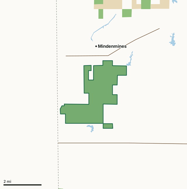
MDC conservation areasState parks and historic sitesShawnee Trail Conservation AreaCounty lineLakeHighway
| Size | 3,685 acres in 2 pieces |
|---|---|
| County | Barton County |
| Deer harvest unit | Barton County |
| MDC lists for hunting | Deer, Bear, Turkey, Rabbit, Squirrel, Dove and Quail |
| MDC area number | 9016 |
| MDC region | Southwest |
| Camping (MDC) | individual campsites |
| Nearest towns | Mindenmines (next to it), Burgess (7 mi) and Liberal (7 mi) |
What is Shawnee Trail Conservation Area like?
The 3,635-acre area takes its name from a trail through the area that played a major role in the history of this country. This trail, sometimes called the Texas Road, was at various times followed by Native Americans, traders heading toward Santa Fe, settlers moving to Texas, and Texas cattlemen heading to Sedalia, Quincy, and Chicago. Between 1845 and 1858, the Shawnee Trail became an important cattle route for moving Texas beef to eastern markets and later to Independence, Kansas City, and Westport, where settlers moving to California and Oregon bought provisions before starting their long trips. As many as 50,000 head per year made the trip from Austin and Waco to the northern markets.
Shawnee Trail Conservation Area offers opportunities for hunting, fishing, hiking, birding, camping, and nature photography. During your visit to the area you may observe wildlife management, research, and soil conservation projects in progress. Sharecrop agreements with local farmers help provide food and cover for wildlife. Discing and controlled burning are used regularly to manipulate vegetation in the fields to improve habitat for wildlife. Shrub plantings provide woody cover for quail, rabbits, and other wildlife species. The grasslands, marshes, and old fields provide opportunities to view unique bird species such as shorteared owls, marsh wrens, Henslow's sparrows, northern harriers, merlins, and various migrant shorebirds. Lakes on the area are often used by shorebirds and waterfowl. Deer hunting is allowed by archery and muzzleloader method only. An ADA fishing dock can be...
In MDC's words, from the Shawnee Trail Conservation Area page.
What can you hunt on Shawnee Trail Conservation Area?
MDC's page for Shawnee Trail Conservation Area lists: Deer: muzzleloader and archery, antlerless permits allowed; Bear: archery and firearms; Turkey: archery and firearms; Rabbit; Squirrel; Dove; Quail.
What are the rules on Shawnee Trail Conservation Area?
Field Trials: Field trials are allowed on this department area only by special use permit. To obtain a special use permit, contact the area manager at the phone number listed for this area in the area details section.
Every conservation area also follows MDC's standard rules in Chapter 11 of the Wildlife Code; the area's full rules are on MDC's site.
How many deer are taken around Shawnee Trail Conservation Area?
Shawnee Trail Conservation Area lies in Barton County. Hunters checked 1,844 deer in Barton County in 2025, against 1,850 in 2024.
| County | Shawnee Trail Conservation Area acres in it | Deer, 2025 | Deer, 2024 | Deer, 2023 |
|---|---|---|---|---|
| Barton County | 3,685 | 1,844 | 1,850 | 1,966 |
Harvest for the whole county, not the conservation area alone: MDC deer harvest summaries (2021 to 2025 seasons).
How do you get to Shawnee Trail Conservation Area?
MDC's directions: From Mindenmines take Highway 160 east, then Route M south 1 mile to the area.
Nearest towns: Mindenmines (next to it), Burgess (7 miles), Liberal (7 miles) and Iantha (9 miles). Highways within 5 miles: MO 43, MO 126 and US 160.
What other public land is near Shawnee Trail Conservation Area?
MDC lands within 10 miles:
- The Lester R. Davis Memorial Forest: 79 acres, 2.2 miles away
- Mon-Shon Prairie Conservation Area: 80 acres, 3.4 miles away
- Wah-Sha-She Prairie: 154 acres, 7.3 miles away
- Redwing Prairie Conservation Area: 166 acres, 8.7 miles away
- Bethel Prairie Conservation Area: 259 acres, 9.9 miles away
Public land within 3 miles of Shawnee Trail Conservation Area
Counting Shawnee Trail Conservation Area itself, 4,171 of the 45,851 acres within 3 miles of its boundary are public land open to the public (9.1%), by USGS PAD-US 4.1 and MDC conservation area boundaries.
| Manager | Acres within 3 miles |
|---|---|
| MDC conservation areas | 3,908 |
| State parks and historic sites | 263 |
Questions hunters ask
Where is Shawnee Trail Conservation Area?
In Barton County, next to Mindenmines.
Can you deer hunt on Shawnee Trail Conservation Area?
Yes, by MDC's page: muzzleloader and archery, antlerless permits allowed.
How much public land is around Shawnee Trail Conservation Area?
4,171 acres within 3 miles of its boundary, Shawnee Trail Conservation Area included, by USGS PAD-US 4.1 and MDC conservation area boundaries. The closest other MDC area is The Lester R. Davis Memorial Forest (2.2 miles).
Get a Missouri hunt plan when they open
Hunt plans for Missouri are coming. Join the list and you'll hear first. The first 50 hunters in each new state get their plan free.
Until then, the free FilledTag app for iPhone has a map that works in every state, Missouri included.
Where these facts come from
- Area description, species, rules and directions: MDC, Shawnee Trail Conservation Area; MDC conservation area boundaries.
- Boundary and acres: MDC's map layer above. Surrounding public land: USGS PAD-US 4.1 (fee land open to the public) and MDC conservation area boundaries.
- Deer harvest: MDC deer harvest summaries (2021 to 2025 seasons).
FilledTag is not part of the Missouri Department of Conservation. Check MDC's rules and posted signs before you go.