Smoky Waters Conservation Area: hunting and access
Smoky Waters Conservation Area is 1,143 acres of MDC land in Osage and Cole counties, 2 miles from Tebbetts. MDC lists deer hunting here (archery and firearms, antlerless permits allowed). Hunters checked 3,740 deer in Osage County in 2025.
Data updated October 2026. Area facts: MDC's conservation area data, read 2026-10. Harvest: MDC deer harvest summaries, 2021 to 2025.
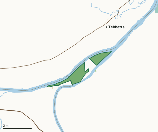
MDC conservation areasNational wildlife refugesState parks and historic sitesSmoky Waters Conservation AreaCounty lineLakeHighway
| Size | 1,143 acres (1,041 by MDC's page) in 2 pieces |
|---|---|
| Counties | Osage County and Cole County |
| Deer harvest unit | Osage County, Cole County |
| MDC lists for hunting | Deer, Bear, Turkey and Rabbit |
| MDC area number | 9524 |
| MDC region | Central |
| Camping (MDC) | boat-in along missouri river |
| Nearest towns | Tebbetts (2 mi), Taos (5 mi) and Mokane (7 mi) |
What is Smoky Waters Conservation Area like?
Smoky Waters Conservation Area in Cole County is located on a peninsula formed by the confluence of the Missouri and Osage Rivers. To get there from Highway 50/63, east of Jefferson City, go north on Route J and proceed into Osage City. Turn east after crossing the railroad tracks and follow Engineer's Road out onto the peninsula. There are two public access parking lots in the 1,041 acre site.
Historically, the peninsula was an island, known as Dodd's Island. Construction of the diversion levee by the Army Corps of Engineers linked the island to the mainland. The area is divided into two tracts separated by private property. The easternmost tract is accessible only by foot along the diversion levee, or from the river by boat. During flood events, Engineer's Road may be impassable. In 1804 the Lewis and Clark expedition camped at the base of what is now known as Clark's Hill, near the first/westernmost parking lot. Visitors can access Clark's Hill and view the Missouri and Osage River valleys via a one-half mile trail through Clark's Hill/Norton State Historic Site. To get there, from Osage City, follow Hickory St. until it dead ends at the Historic Site's parking area. Smoky Waters Conservation Area contains riparian and successional forest, old field, marsh, and scour holes....
In MDC's words, from the Smoky Waters Conservation Area page.
What can you hunt on Smoky Waters Conservation Area?
MDC's page for Smoky Waters Conservation Area lists: Deer: archery and firearms, antlerless permits allowed; Bear: archery and firearms; Turkey: archery and firearms; Rabbit.
What are the rules on Smoky Waters Conservation Area?
MDC's standard conservation area rules (Chapter 11 of the Wildlife Code) apply; the area's rules on MDC's site list any it adds.
How many deer are taken around Smoky Waters Conservation Area?
Smoky Waters Conservation Area lies in 2 counties. Hunters checked 3,740 deer in Osage County in 2025, against 3,129 in 2024.
| County | Smoky Waters Conservation Area acres in it | Deer, 2025 | Deer, 2024 | Deer, 2023 |
|---|---|---|---|---|
| Osage County | 1,002 | 3,740 | 3,129 | 3,966 |
| Cole County | 141 | 2,029 | 1,866 | 2,049 |
Harvest for the whole county, not the conservation area alone: MDC deer harvest summaries (2021 to 2025 seasons).
How do you get to Smoky Waters Conservation Area?
MDC's directions: From Osage City, take Engineer Road east 2 miles.
Nearest towns: Tebbetts (2 miles), Taos (5 miles), Mokane (7 miles) and Holts Summit (7 miles). Highways within 5 miles: US 50, US 63 and MO 94.
What other public land is near Smoky Waters Conservation Area?
MDC lands within 10 miles:
- Mari-Osa Access: 28 acres, 4.6 miles away
- Dr. Bernard Bruns Access: 84 acres, 7.4 miles away
Public land within 3 miles of Smoky Waters Conservation Area
Counting Smoky Waters Conservation Area itself, 1,170 of the 40,305 acres within 3 miles of its boundary are public land open to the public (2.9%), by USGS PAD-US 4.1 and MDC conservation area boundaries.
| Manager | Acres within 3 miles |
|---|---|
| MDC conservation areas | 1,151 |
| State parks and historic sites | 19 |
Questions hunters ask
Where is Smoky Waters Conservation Area?
In Osage and Cole counties, 2 miles from Tebbetts.
Can you deer hunt on Smoky Waters Conservation Area?
Yes, by MDC's page: archery and firearms, antlerless permits allowed.
How much public land is around Smoky Waters Conservation Area?
1,170 acres within 3 miles of its boundary, Smoky Waters Conservation Area included, by USGS PAD-US 4.1 and MDC conservation area boundaries. The closest other MDC area is Mari-Osa Access (4.6 miles).
Get a Missouri hunt plan when they open
Hunt plans for Missouri are coming. Join the list and you'll hear first. The first 50 hunters in each new state get their plan free.
Until then, the free FilledTag app for iPhone has a map that works in every state, Missouri included.
Where these facts come from
- Area description, species, rules and directions: MDC, Smoky Waters Conservation Area; MDC conservation area boundaries.
- Boundary and acres: MDC's map layer above. Surrounding public land: USGS PAD-US 4.1 (fee land open to the public) and MDC conservation area boundaries.
- Deer harvest: MDC deer harvest summaries (2021 to 2025 seasons).
FilledTag is not part of the Missouri Department of Conservation. Check MDC's rules and posted signs before you go.