Spring Creek Gap Conservation Area: hunting and access
Spring Creek Gap Conservation Area is 1,785 acres of MDC land in Maries County, 8 miles from Vienna. MDC lists deer hunting here (archery and firearms, antlerless permits allowed). Hunters checked 2,204 deer in Maries County in 2025.
Data updated October 2026. Area facts: MDC's conservation area data, read 2026-10. Harvest: MDC deer harvest summaries, 2021 to 2025.
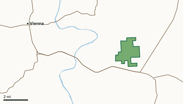
MDC conservation areasSpring Creek Gap Conservation AreaCounty lineLakeHighway
| Size | 1,785 acres |
|---|---|
| County | Maries County |
| Deer harvest unit | Maries County |
| MDC lists for hunting | Deer, Bear, Turkey and Squirrel |
| MDC area number | 4644 |
| MDC region | Central |
| Camping (MDC) | open camping - walk-in/float-in/backpack and designated camping sites |
| Nearest towns | Vienna (8 mi), Belle (9 mi) and Freeburg (12 mi) |
What is Spring Creek Gap Conservation Area like?
Spring Creek Gap Conservation Area is in Maries County, approximately 10 miles southeast of Vienna and 14 miles north of Rolla on old Highway 63. This 1,816-acre area was acquired in three parts, starting with the 1948 purchase of a 280-acre parcel known as the Vichy Towersite. The Conservation Department purchased an additional 1,495 acres in 1978 from Dr. A.W. Strickle and added a 40-acre tract in 1980.
Spring Creek Gap, with its combination of forests, woodlands, steep topography, dolomite glades and old fields, is an extremely scenic area, especially during the fall color change. The forest has a nice display of spring wildflowers in the ravines. Cedar Creek, an intermittent stream, bisects the area. In 1982, 40 acres on Spring Creek Gap Conservation Area was designated Natural Area and in 2007 the Natural Area was expanded to 692 acres and named Spring Creek Gap Glades Natural Area. Yellow coneflowers, silky asters and blazing stars are some of the colorful plants growing on the natural area. The majority of the forest is made up of oak and hickory in dry dolomite woodlands. White and black oak predominate on rich north and east slopes of the area, and post oak, chinquapin oak, blackjack oak, and eastern red cedar mark woodlands and glades. A planting of shortleaf pine may be seen...
In MDC's words, from the Spring Creek Gap Conservation Area page.
What can you hunt on Spring Creek Gap Conservation Area?
MDC's page for Spring Creek Gap Conservation Area lists: Deer: archery and firearms, antlerless permits allowed; Bear: archery and firearms; Turkey: archery and firearms; Squirrel.
What are the rules on Spring Creek Gap Conservation Area?
MDC's standard conservation area rules (Chapter 11 of the Wildlife Code) apply; the area's rules on MDC's site list any it adds.
How many deer are taken around Spring Creek Gap Conservation Area?
Spring Creek Gap Conservation Area lies in Maries County. Hunters checked 2,204 deer in Maries County in 2025, against 1,910 in 2024.
| County | Spring Creek Gap Conservation Area acres in it | Deer, 2025 | Deer, 2024 | Deer, 2023 |
|---|---|---|---|---|
| Maries County | 1,785 | 2,204 | 1,910 | 2,391 |
Harvest for the whole county, not the conservation area alone: MDC deer harvest summaries (2021 to 2025 seasons).
How do you get to Spring Creek Gap Conservation Area?
MDC's directions: From Vienna, take Highway 63 south approximately 10 miles, or north of Rolla on Highway 63 approximately 14 miles, take Old 63 north about 0.25 mile to the area.
Nearest towns: Vienna (8 miles), Belle (9 miles), Freeburg (12 miles) and Bland (13 miles). Highways within 5 miles: MO 28, US 63, MO 42 and MO 68.
What other public land is near Spring Creek Gap Conservation Area?
Public land within 3 miles of Spring Creek Gap Conservation Area
Counting Spring Creek Gap Conservation Area itself, 1,786 of the 34,548 acres within 3 miles of its boundary are public land open to the public (5.2%), by USGS PAD-US 4.1 and MDC conservation area boundaries.
| Manager | Acres within 3 miles |
|---|---|
| MDC conservation areas | 1,786 |
Questions hunters ask
Where is Spring Creek Gap Conservation Area?
In Maries County, 8 miles from Vienna.
Can you deer hunt on Spring Creek Gap Conservation Area?
Yes, by MDC's page: archery and firearms, antlerless permits allowed.
How much public land is around Spring Creek Gap Conservation Area?
1,786 acres within 3 miles of its boundary, Spring Creek Gap Conservation Area included, by USGS PAD-US 4.1 and MDC conservation area boundaries.
Get a Missouri hunt plan when they open
Hunt plans for Missouri are coming. Join the list and you'll hear first. The first 50 hunters in each new state get their plan free.
Until then, the free FilledTag app for iPhone has a map that works in every state, Missouri included.
Where these facts come from
- Area description, species, rules and directions: MDC, Spring Creek Gap Conservation Area; MDC conservation area boundaries.
- Boundary and acres: MDC's map layer above. Surrounding public land: USGS PAD-US 4.1 (fee land open to the public) and MDC conservation area boundaries.
- Deer harvest: MDC deer harvest summaries (2021 to 2025 seasons).
FilledTag is not part of the Missouri Department of Conservation. Check MDC's rules and posted signs before you go.