Thomas Hill Reservoir Conservation Area: hunting and access
Thomas Hill Reservoir Conservation Area is 9,320 acres of MDC land in Macon and Randolph counties, 4 miles from Bevier. MDC lists deer hunting here (archery and firearms, antlerless permits allowed). Hunters checked 4,525 deer in Macon County in 2025.
Data updated October 2026. Area facts: MDC's conservation area data, read 2026-10. Harvest: MDC deer harvest summaries, 2021 to 2025.
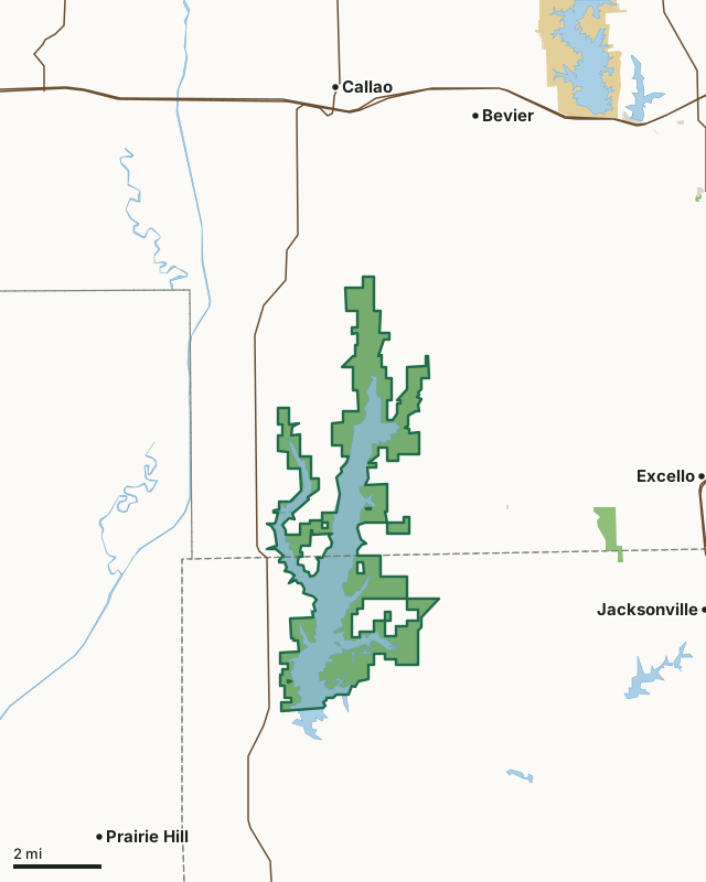
MDC conservation areasFederal land, mostly Corps of Engineers lakesState parks and historic sitesCounty, city and regional landThomas Hill Reservoir Conservation AreaCounty lineLakeHighway
| Size | 9,320 acres in 3 pieces |
|---|---|
| Counties | Macon County and Randolph County |
| Deer harvest unit | Macon County, Randolph County |
| MDC lists for hunting | Deer, Turkey, Rabbit, Squirrel, Dove and Quail |
| MDC area number | 6504 |
| MDC region | Northeast |
| Camping (MDC) | individual campsites |
| Nearest towns | Bevier (4 mi), Callao (4 mi) and Prairie Hill (5 mi) |
What is Thomas Hill Reservoir Conservation Area like?
The Thomas Hill Reservoir Conservation Area property is owned by Associated Electric Cooperative Inc. of Springfield, MO. The reservoir was constructed to provide a source of water to cool the power plant during energy production. The public is restricted from a small portion of the area near the power plant.
The area is managed by the Conservation Department under a multi-year lease. The area consists of the 4,950-acre Thomas Hill Reservoir, surrounded by 4,381 acres of land which is approximately 60 percent open and 40 percent forested. The area has 2.2 miles of stream frontage on the Middle Fork of the Little Chariton River. The north end of the reservoir features several wetland units, created and maintained by beavers, that attract a variety of nesting and migrating birds. Management of the area includes farming, timber harvest, and controlled burns to improve wildlife habitat and increase species diversity. Thomas Hill Reservoir is managed primarily for largemouth bass, crappie, hybrid striped bass and catfish. The warm water discharge remains ice-free during the winter providing a unique winter fishing opportunity. Bald eagles are present on the reservoir and can usually be seen from...
In MDC's words, from the Thomas Hill Reservoir Conservation Area page.
What can you hunt on Thomas Hill Reservoir Conservation Area?
MDC's page for Thomas Hill Reservoir Conservation Area lists: Deer: archery and firearms, antlerless permits allowed; Turkey: archery and firearms; Rabbit; Squirrel; Dove; Quail.
What are the rules on Thomas Hill Reservoir Conservation Area?
MDC's standard conservation area rules (Chapter 11 of the Wildlife Code) apply; the area's rules on MDC's site list any it adds.
How many deer are taken around Thomas Hill Reservoir Conservation Area?
Thomas Hill Reservoir Conservation Area lies in 2 counties. Hunters checked 4,525 deer in Macon County in 2025, against 4,489 in 2024.
| County | Thomas Hill Reservoir Conservation Area acres in it | Deer, 2025 | Deer, 2024 | Deer, 2023 |
|---|---|---|---|---|
| Macon County | 4,984 | 4,525 | 4,489 | 4,746 |
| Randolph County | 4,336 | 2,476 | 2,545 | 2,987 |
Harvest for the whole county, not the conservation area alone: MDC deer harvest summaries (2021 to 2025 seasons).
How do you get to Thomas Hill Reservoir Conservation Area?
MDC's directions: From Macon, take Highway 36 west 5.25 miles, then Route C south 10 miles to College Mound, then Route T west 2.40 miles to the main entrance.
Nearest towns: Bevier (4 miles), Callao (4 miles), Prairie Hill (5 miles) and Jacksonville (6 miles). Highways within 5 miles: MO 3 and US 36.
What other public land is near Thomas Hill Reservoir Conservation Area?
MDC lands within 10 miles:
- Bee Hollow Conservation Area: 257 acres, 3.9 miles away
- Macon City Lake: 189 acres, 6.8 miles away
- Sugar Creek Lake (Moberly): 310 acres, 8.6 miles away
- Long Branch Lake Management Lands: 2,506 acres, 9.8 miles away
- Dodd Access: 41 acres, 9.9 miles away
Public land within 3 miles of Thomas Hill Reservoir Conservation Area
Counting Thomas Hill Reservoir Conservation Area itself, 9,323 of the 80,497 acres within 3 miles of its boundary are public land open to the public (11.6%), by USGS PAD-US 4.1 and MDC conservation area boundaries.
| Manager | Acres within 3 miles |
|---|---|
| MDC conservation areas | 9,320 |
| State parks and historic sites | 3 |
Questions hunters ask
Where is Thomas Hill Reservoir Conservation Area?
In Macon and Randolph counties, 4 miles from Bevier.
Can you deer hunt on Thomas Hill Reservoir Conservation Area?
Yes, by MDC's page: archery and firearms, antlerless permits allowed.
How much public land is around Thomas Hill Reservoir Conservation Area?
9,323 acres within 3 miles of its boundary, Thomas Hill Reservoir Conservation Area included, by USGS PAD-US 4.1 and MDC conservation area boundaries. The closest other MDC area is Bee Hollow Conservation Area (3.9 miles).
Get a Missouri hunt plan when they open
Hunt plans for Missouri are coming. Join the list and you'll hear first. The first 50 hunters in each new state get their plan free.
Until then, the free FilledTag app for iPhone has a map that works in every state, Missouri included.
Where these facts come from
- Area description, species, rules and directions: MDC, Thomas Hill Reservoir Conservation Area; MDC conservation area boundaries.
- Boundary and acres: MDC's map layer above. Surrounding public land: USGS PAD-US 4.1 (fee land open to the public) and MDC conservation area boundaries.
- Deer harvest: MDC deer harvest summaries (2021 to 2025 seasons).
FilledTag is not part of the Missouri Department of Conservation. Check MDC's rules and posted signs before you go.