Upper Mississippi Conservation Area: hunting and access
Upper Mississippi Conservation Area is 12,715 acres of MDC land in St. Charles, Marion, Lincoln, Pike, Lewis and Ralls counties, next to Clarksville. MDC lists deer hunting here (archery only, antlerless permits allowed). Hunters checked 2,141 deer in St. Charles County in 2025.
Data updated October 2026. Area facts: MDC's conservation area data, read 2026-10. Harvest: MDC deer harvest summaries, 2021 to 2025.
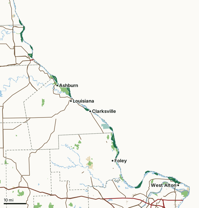
MDC conservation areasFederal land, mostly Corps of Engineers lakesNational wildlife refugesState parks and historic sitesCounty, city and regional landLand trusts and other open landUpper Mississippi Conservation AreaCounty lineLakeHighway
| Size | 12,715 acres (14,912 by MDC's page) in 48 pieces |
|---|---|
| Counties | St. Charles County, Marion County, Lincoln County, Pike County, Lewis County and Ralls County |
| Deer harvest unit | St. Charles County, Marion County, Lincoln County, Pike County, Lewis County, Ralls County |
| MDC lists for hunting | Deer, Turkey and Squirrel |
| MDC area number | 6131 |
| MDC region | St. Louis |
| Nearest towns | Clarksville (next to it), West Alton (next to it) and Ashburn (next to it) |
What is Upper Mississippi Conservation Area like?
The Upper Mississippi Conservation Area, rich in wildlife and habitat diversity, stretches from the Melvin Price Lock and Dam at Alton, Illinois, to LaGrange, Missouri. It is composed of 87 tracts of federal lands totaling over 11,000 acres and managed under a cooperative agreement between the U.S. Fish and Wildlife Service and the U.S. Army Corps of Engineers.
Accumulating silt reduced the productivity of this wetland area, and navigation and recreational boating helped move bottom sediments into backwaters and chutes, reducing the number of wetland habitats. In an effort to balance navigation needs and the need for wildlife habitat, Congress authorized the Environmental Management Program in 1986. This federal program is designed to protect the resources and guide future river management. One of the elements of this program was the construction of Habitat Rehabilitation and Enhancement Projects. Water regulation is now possible depending on river elevations, further improving habitat for fish and wildlife. Many people visit the riverine area to enjoy the outdoors, hunt and hike on the new sediment deflection levee or fish below the water control structures.
In MDC's words, from the Upper Mississippi Conservation Area page.
What can you hunt on Upper Mississippi Conservation Area?
MDC's page for Upper Mississippi Conservation Area lists: Deer: archery only, antlerless permits allowed; Turkey: archery and firearms; Squirrel.
What are the rules on Upper Mississippi Conservation Area?
Decoys and Blinds: On portions of this department area designated as restricted waterfowl hunting areas, blind sites are designated and allotted through a system of registration and drawing established by the department. Blinds must be constructed in accordance with specifications, dates, and other requirements as described in the biannual Upper Mississippi Conservation Area Waterfowl Hunting Information booklet. On portions of this area designated as open, blinds may be constructed without site restrictions. Blinds or blind sites on both restricted and open portions of the area may not be locked, transferred,...
Every conservation area also follows MDC's standard rules in Chapter 11 of the Wildlife Code; the area's full rules are on MDC's site.
How many deer are taken around Upper Mississippi Conservation Area?
Upper Mississippi Conservation Area lies in 6 counties. Hunters checked 2,141 deer in St. Charles County in 2025, against 2,231 in 2024.
| County | Upper Mississippi Conservation Area acres in it | Deer, 2025 | Deer, 2024 | Deer, 2023 |
|---|---|---|---|---|
| St. Charles County | 4,112 | 2,141 | 2,231 | 2,297 |
| Marion County | 2,564 | 2,339 | 2,485 | 2,517 |
| Lincoln County | 2,274 | 4,503 | 4,098 | 4,515 |
| Pike County | 2,256 | 4,848 | 4,425 | 4,855 |
| Lewis County | 467 | 2,407 | 2,502 | 2,359 |
| Ralls County | 270 | 2,742 | 2,845 | 2,733 |
Harvest for the whole county, not the conservation area alone: MDC deer harvest summaries (2021 to 2025 seasons).
How do you get to Upper Mississippi Conservation Area?
MDC's directions: This area consists of 87 scattered tracts adjacent to the Mississippi River and some river islands.
Nearest towns: Clarksville (next to it), West Alton (next to it), Ashburn (next to it) and Foley (2 miles). Highways within 5 miles: US 61, MO 79, US 24, MO 94 and US 67.
What other public land is near Upper Mississippi Conservation Area?
MDC lands within 10 miles:
- B. K. Leach Memorial Conservation Area: 4,323 acres, next to it
- Ted Shanks Conservation Area: 6,801 acres, next to it
- Julian Steyermark Woods Conservation Area: 78 acres, next to it
- Fabius Chute Access: 36 acres, next to it
- Soulard Access: 257 acres, next to it
- Prairie Slough Conservation Area: 610 acres, next to it
Public land within 3 miles of Upper Mississippi Conservation Area
Counting Upper Mississippi Conservation Area itself, 34,849 of the 404,097 acres within 3 miles of its boundary are public land open to the public (8.6%), by USGS PAD-US 4.1 and MDC conservation area boundaries.
| Manager | Acres within 3 miles |
|---|---|
| MDC conservation areas | 29,879 |
| National wildlife refuges | 3,105 |
| County, city and regional land | 1,248 |
| State parks and historic sites | 321 |
| Federal land, mostly Corps of Engineers lakes | 205 |
| Land trusts and other open land | 91 |
Questions hunters ask
Where is Upper Mississippi Conservation Area?
In St. Charles, Marion, Lincoln, Pike, Lewis and Ralls counties, next to Clarksville.
Can you deer hunt on Upper Mississippi Conservation Area?
Yes, by MDC's page: archery only, antlerless permits allowed.
How much public land is around Upper Mississippi Conservation Area?
34,849 acres within 3 miles of its boundary, Upper Mississippi Conservation Area included, by USGS PAD-US 4.1 and MDC conservation area boundaries. The closest other MDC area is B. K. Leach Memorial Conservation Area (next to it).
Get a Missouri hunt plan when they open
Hunt plans for Missouri are coming. Join the list and you'll hear first. The first 50 hunters in each new state get their plan free.
Until then, the free FilledTag app for iPhone has a map that works in every state, Missouri included.
Where these facts come from
- Area description, species, rules and directions: MDC, Upper Mississippi Conservation Area; MDC conservation area boundaries.
- Boundary and acres: MDC's map layer above. Surrounding public land: USGS PAD-US 4.1 (fee land open to the public) and MDC conservation area boundaries.
- Deer harvest: MDC deer harvest summaries (2021 to 2025 seasons).
FilledTag is not part of the Missouri Department of Conservation. Check MDC's rules and posted signs before you go.
Missouri hunting St. Charles County Marion County Lincoln County Pike County Lewis County Ralls County