White River Trace Conservation Area: hunting and access
White River Trace Conservation Area is 2,043 acres of MDC land in Dent County, 8 miles from Edgar Springs. MDC lists deer hunting here (archery only, antlerless permits allowed). Hunters checked 2,659 deer in Dent County in 2025.
Data updated October 2026. Area facts: MDC's conservation area data, read 2026-10. Harvest: MDC deer harvest summaries, 2021 to 2025.
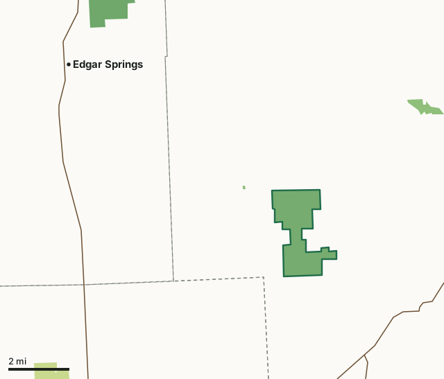
MDC conservation areasNational forestOther state landWhite River Trace Conservation AreaCounty lineHighway
| Size | 2,043 acres |
|---|---|
| County | Dent County |
| Deer harvest unit | Dent County |
| MDC lists for hunting | Deer, Bear, Turkey, Rabbit, Squirrel, Dove and Quail |
| MDC area number | 8917 |
| MDC region | Ozark |
| Camping (MDC) | individual campsites |
| Nearest towns | Edgar Springs (8 mi), Licking (9 mi) and Salem (10 mi) |
What is White River Trace Conservation Area like?
This 2,044-acre area, which was purchased in 1988, takes its name from an old Indian trail running across the southeast portion of the area.
Under the Indian removal Act of 1830, the Cherokee were removed from their native lands in the southeastern United States and forcibly moved to Oklahoma. Peter Hildebrand's detachment of 1,766 Cherokees separated from other groups in Crawford County and traveled through the White River Trace Area in March 1839. They later rejoined the main trail at Marshfield. The White River Trace later became a major route for settlers traveling west. Nearby Mt. Hermon Cemetery began with graves of these early travelers. White River Trace is about 80 percent open ground consisting mainly of native warm-season grasses and early successional plant types. Management of the area has produced quality upland wildlife habitat, especially for bobwhite quail and other grassland bird species, such as grasshopper sparrows and dickcissels. This type of habitat is uncommon on the Salem plateau and the area...
In MDC's words, from the White River Trace Conservation Area page.
What can you hunt on White River Trace Conservation Area?
MDC's page for White River Trace Conservation Area lists: Deer: archery only, antlerless permits allowed; Bear: archery and firearms; Turkey: archery and firearms; Rabbit; Squirrel; Dove; Quail.
What are the rules on White River Trace Conservation Area?
Field Trials: Field trials are allowed on this department area only by special use permit. To obtain a special use permit, contact the area manager at the phone number listed for this area in the area details section.
Every conservation area also follows MDC's standard rules in Chapter 11 of the Wildlife Code; the area's full rules are on MDC's site.
How many deer are taken around White River Trace Conservation Area?
White River Trace Conservation Area lies in Dent County. Hunters checked 2,659 deer in Dent County in 2025, against 2,584 in 2024.
| County | White River Trace Conservation Area acres in it | Deer, 2025 | Deer, 2024 | Deer, 2023 |
|---|---|---|---|---|
| Dent County | 2,043 | 2,659 | 2,584 | 3,865 |
Harvest for the whole county, not the conservation area alone: MDC deer harvest summaries (2021 to 2025 seasons).
How do you get to White River Trace Conservation Area?
MDC's directions: From Highway 72 in Salem, take Route H west approximately 9 miles to Dent County Road 253. Headquarters is approximately 1.30 miles south on Dent County Road 253.
Nearest towns: Edgar Springs (8 miles), Licking (9 miles), Salem (10 miles) and Raymondville (19 miles). Highways within 5 miles: MO 32 and MO 119.
What other public land is near White River Trace Conservation Area?
MDC lands within 10 miles:
- Gerhild and Graham Brown Conservation Area: 191 acres, 4.1 miles away
- R. F. Clement Memorial Forest and Wildlife Area: 513 acres, 7.4 miles away
Public land within 3 miles of White River Trace Conservation Area
Counting White River Trace Conservation Area itself, 2,051 of the 37,565 acres within 3 miles of its boundary are public land open to the public (5.5%), by USGS PAD-US 4.1 and MDC conservation area boundaries.
| Manager | Acres within 3 miles |
|---|---|
| MDC conservation areas | 2,051 |
Questions hunters ask
Where is White River Trace Conservation Area?
In Dent County, 8 miles from Edgar Springs.
Can you deer hunt on White River Trace Conservation Area?
Yes, by MDC's page: archery only, antlerless permits allowed.
How much public land is around White River Trace Conservation Area?
2,051 acres within 3 miles of its boundary, White River Trace Conservation Area included, by USGS PAD-US 4.1 and MDC conservation area boundaries. The closest other MDC area is Gerhild and Graham Brown Conservation Area (4.1 miles).
Get a Missouri hunt plan when they open
Hunt plans for Missouri are coming. Join the list and you'll hear first. The first 50 hunters in each new state get their plan free.
Until then, the free FilledTag app for iPhone has a map that works in every state, Missouri included.
Where these facts come from
- Area description, species, rules and directions: MDC, White River Trace Conservation Area; MDC conservation area boundaries.
- Boundary and acres: MDC's map layer above. Surrounding public land: USGS PAD-US 4.1 (fee land open to the public) and MDC conservation area boundaries.
- Deer harvest: MDC deer harvest summaries (2021 to 2025 seasons).
FilledTag is not part of the Missouri Department of Conservation. Check MDC's rules and posted signs before you go.