Wire Road Conservation Area: hunting and access
Wire Road Conservation Area is 1,013 acres of MDC land in Stone County, next to Crane. MDC lists deer hunting here (muzzleloader and archery, antlerless permits allowed). Hunters checked 2,137 deer in Stone County in 2025.
Data updated October 2026. Area facts: MDC's conservation area data, read 2026-10. Harvest: MDC deer harvest summaries, 2021 to 2025.
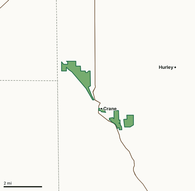
MDC conservation areasWire Road Conservation AreaCounty lineHighway
| Size | 1,013 acres in 4 pieces |
|---|---|
| County | Stone County |
| Deer harvest unit | Stone County |
| MDC lists for hunting | Deer, Bear, Turkey, Rabbit, Squirrel and Dove |
| MDC area number | 8307 |
| MDC region | Southwest |
| Nearest towns | Crane (next to it), Hurley (3 mi) and Marionville (5 mi) |
What is Wire Road Conservation Area like?
Wire Road Conservation Area is a 1,003-acre area located in northwestern Stone County. In 1983, the department purchased 325 acres to officially create Wire Road Conservation Area. Additional land was purchased in the following years to increase the area to it's current size. The area was named Wire Road after a pre-Civil War road that followed a telegraph line between Rolla, MO and Fort Smith, AR that ran through the area. A field at the junction of Crane Creek and the original Wire Road was an important encampment during the Civil War. It was occupied by several thousand Confederate troops before and after the Battle of Wilson's Creek. A fork of the Cherokee Trail of Tears also passed through this area, as well as the famous Butterfield Stage Route. A major trail of some sort is thought to have existed on this area since Europeans first traveled in Stone County.
Wire Road Conservation Area consists primarily of typical upland oak-hickory forest and bottomland hardwoods, including sycamore, bur oak, northern red oak, and black walnut. Before Department ownership, the bottomland fields were farmed and grazed. Some existing stands of fescue have been converted to annuals and native grasses. The riparian zone along Crane Creek and bottomland fields have been replanted with trees to protect the waterway. Altogther, over 30,000 trees have been planted on the area. Wire Road is a great place if you are tackling the Missouri's Blue Ribbon Trout Slam. Several multiuse trails allow hikers, bicyclists, and horseback riders ways to explore the area.
In MDC's words, from the Wire Road Conservation Area page.
What can you hunt on Wire Road Conservation Area?
MDC's page for Wire Road Conservation Area lists: Deer: muzzleloader and archery, antlerless permits allowed; Bear: archery and firearms; Turkey: archery and firearms; Rabbit; Squirrel; Dove.
What are the rules on Wire Road Conservation Area?
MDC's standard conservation area rules (Chapter 11 of the Wildlife Code) apply; the area's rules on MDC's site list any it adds.
How many deer are taken around Wire Road Conservation Area?
Wire Road Conservation Area lies in Stone County. Hunters checked 2,137 deer in Stone County in 2025, against 1,878 in 2024.
| County | Wire Road Conservation Area acres in it | Deer, 2025 | Deer, 2024 | Deer, 2023 |
|---|---|---|---|---|
| Stone County | 1,013 | 2,137 | 1,878 | 2,387 |
Harvest for the whole county, not the conservation area alone: MDC deer harvest summaries (2021 to 2025 seasons).
How do you get to Wire Road Conservation Area?
MDC's directions: Wire Road Conservation Area consists of several tracts. To get to the largest tract, located northwest of Crane, take Highway 413 north 1.10 miles, then Old Wire Road west 1 mile to a parking lot on the north side of the road.
Nearest towns: Crane (next to it), Hurley (3 miles), Marionville (5 miles) and Aurora (6 miles). Highways within 5 miles: MO 265, MO 173, MO 413, MO 248 and US 60.
What other public land is near Wire Road Conservation Area?
MDC lands within 10 miles:
- Hayes Spring Conservation Area: 97 acres, 5.5 miles away
- H. L. Kerr Access: 50 acres, 5.7 miles away
- Jessie Hollow Conservation Area: 117 acres, 8.9 miles away
- Holland State Forest: 158 acres, 9 miles away
Public land within 3 miles of Wire Road Conservation Area
Counting Wire Road Conservation Area itself, 1,015 of the 41,747 acres within 3 miles of its boundary are public land open to the public (2.4%), by USGS PAD-US 4.1 and MDC conservation area boundaries.
| Manager | Acres within 3 miles |
|---|---|
| MDC conservation areas | 1,015 |
Questions hunters ask
Where is Wire Road Conservation Area?
In Stone County, next to Crane.
Can you deer hunt on Wire Road Conservation Area?
Yes, by MDC's page: muzzleloader and archery, antlerless permits allowed.
How much public land is around Wire Road Conservation Area?
1,015 acres within 3 miles of its boundary, Wire Road Conservation Area included, by USGS PAD-US 4.1 and MDC conservation area boundaries. The closest other MDC area is Hayes Spring Conservation Area (5.5 miles).
Get a Missouri hunt plan when they open
Hunt plans for Missouri are coming. Join the list and you'll hear first. The first 50 hunters in each new state get their plan free.
Until then, the free FilledTag app for iPhone has a map that works in every state, Missouri included.
Where these facts come from
- Area description, species, rules and directions: MDC, Wire Road Conservation Area; MDC conservation area boundaries.
- Boundary and acres: MDC's map layer above. Surrounding public land: USGS PAD-US 4.1 (fee land open to the public) and MDC conservation area boundaries.
- Deer harvest: MDC deer harvest summaries (2021 to 2025 seasons).
FilledTag is not part of the Missouri Department of Conservation. Check MDC's rules and posted signs before you go.