Hunting District 393, East Bridger: elk and deer hunting
Hunting District 393 (East Bridger) is 12.6% public land, most of it national forest (32,665 acres), by Montana's cadastral map of public land (2026). FWP estimates hunters took 507 elk and 598 deer here in 2025. In 2024, the last year FWP counted elk hunters by district, 2,048 elk hunters spent 14,310 days here and took 590 elk.
Data updated October 2026. Harvest: FWP estimates for 2020 to 2025. Seasons: FWP's 2026 regulations. Land: Montana State Library, 2026-10.
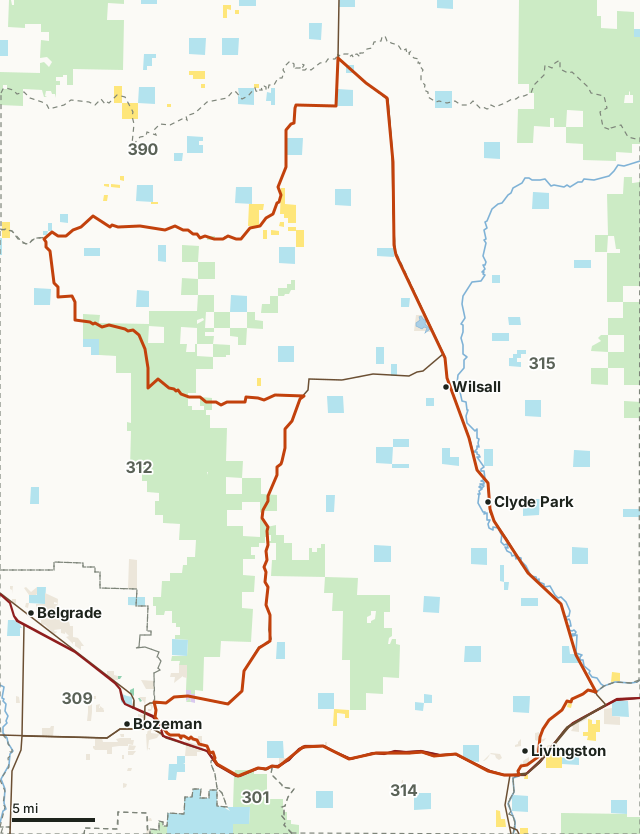
National forestBLMState trust landNational wildlife refugeOther publicHD 393Neighboring districtsLake or riverHighway
| Region | FWP Region 3, Southwest Montana |
|---|---|
| Size | 395,127 acres (617 square miles) |
| Public land | 12.6% (49,920 acres) |
| Block Management | 2 areas, 14,255 acres (2026) |
| Elk harvested, 2025 | 507 (270 bulls) |
| Deer harvested, 2025 | 598 (353 mule deer, 244 white-tailed) |
| General elk license, general season | Brow-tined bulls or antlerless elk |
| Archery only, 2026 | September 5 to October 18 |
| General season, 2026 | October 24 to November 29 |
| Towns in and near it | Livingston, Clyde Park, Wilsall, Bozeman, Belgrade and Manhattan |
HD 393 is the east side of the Bridger Range and the Shields River valley, between Bozeman, Livingston, Wilsall and Ringling. Only 12.6% of it is public land; Block Management adds 14,255 acres.
How much public land is in HD 393?
12.6% of HD 393 is public land: 49,920 of its 395,127 acres. The largest share is national forest, 32,665 acres or 8.3% of the district.
| Manager | Acres | Share of HD 393 |
|---|---|---|
| National forest | 32,665 | 8.3% |
| State trust land | 15,471 | 3.9% |
| BLM | 1,696 | 0.4% |
| Other public | 1,203 | 0.3% |
| National wildlife refuge | 88 | under 0.1% |
Measured by FilledTag inside FWP's district boundary from Montana Cadastral Public Lands, Montana State Library, published 2026. State trust land is open to hunting with a Conservation License where it can be reached legally; many sections touch no public road.
Block Management in HD 393
FWP's 2026 Block Management map shows 2 areas in HD 393, 14,255 acres of private land open to hunters under the program. The largest: Arthun Ranches (8,440 acres, Type 1) and Higgins Ranch (5,815 acres, Type 1). Each area has its own rules and map from FWP. FWP Block Management.
How many elk are harvested in HD 393?
FWP estimates 507 elk were harvested in HD 393 in 2025: 270 bulls, 237 cows and 0 calves. FWP last counted elk hunters by district in 2024: 2,048 hunters took 590 elk, about 29 elk for every 100 hunters.
| Year | Elk harvested | Bulls | Cows | Calves | Bulls 6 points or more | Elk hunters | Hunter days | Elk per 100 hunters |
|---|---|---|---|---|---|---|---|---|
| 2025 | 507 | 270 | 237 | 0 | 169 | not counted | not counted | |
| 2024 | 590 | 237 | 345 | 8 | 155 | 2,048 | 14,310 | 29 |
| 2023 | 542 | 298 | 229 | 15 | 154 | not counted | not counted | |
| 2022 | 636 | 317 | 298 | 21 | 185 | 1,861 | 12,237 | 34 |
| 2021 | 486 | 233 | 250 | 3 | 135 | not counted | not counted | |
| 2020 | 565 | 345 | 203 | 17 | 192 | 1,877 | 11,472 | 30 |
Source: FWP Harvest Estimates (elk, 2020 to 2025). FWP counts hunters and days by district every other year; "not counted" means FWP did not publish that year's count. Elk per 100 hunters is worked out from FWP's own two figures.
How many deer are harvested in HD 393?
FWP estimates 598 deer were harvested in HD 393 in 2025: 353 mule deer and 244 white-tailed deer. In 2025, 1,671 deer hunters spent 9,555 days here.
| Year | Deer harvested | Mule deer | White-tailed deer | Bucks | Does | Bucks 4 points or more | Deer hunters | Hunter days |
|---|---|---|---|---|---|---|---|---|
| 2025 | 598 | 353 | 244 | 464 | 134 | 310 | 1,671 | 9,555 |
| 2024 | 596 | 345 | 251 | 486 | 107 | 334 | not counted | not counted |
| 2023 | 607 | 375 | 233 | 463 | 143 | 261 | 1,548 | 9,702 |
| 2022 | 578 | 332 | 246 | 422 | 153 | 231 | not counted | not counted |
| 2021 | 572 | 354 | 218 | 439 | 133 | 297 | 1,405 | 9,290 |
| 2020 | 599 | 354 | 246 | 424 | 175 | 268 | not counted | not counted |
Source: FWP Harvest Estimates (deer, 2020 to 2025).
When is elk season in HD 393 in 2026?
Archery only: September 5 to October 18. General season: October 24 to November 29, 2026. Every elk license and permit FWP lists for HD 393:
| License or permit | What may be taken | Apply by | Quota | Archery only | General | Other seasons | FWP's restrictions |
|---|---|---|---|---|---|---|---|
| General Elk License | Brow-tined Bull or Antlerless Elk | Sep 5-Oct 18 | Oct 24-Nov 29 | Muzzleloader: Dec 12-Dec 20 | |||
| General Elk License | Either-sex Elk | Sep 5-Oct 18 | Oct 24-Nov 29 | Muzzleloader: Dec 12-Dec 20 | Only youth ages 12-15 and hunters with a PTHFV. | ||
| General Elk License | Antlerless Elk | Late: Nov 30-Feb 15 | Not Valid on National Forest Lands. | ||||
| Elk B License: 397-00 | Antlerless Elk | OTC: Jun 15 | UNL | Early: Aug 15-Sep 4 | One per hunter. Multi-district license. Only valid on private lands. | ||
| Elk B License: 397-00 | Antlerless Elk | OTC: Jun 15 | UNL | Sep 5-Oct 18 | Oct 24-Nov 29 | Late: Nov 30-Feb 15 | One per hunter. Multi-district license. Not valid on National Forest Lands. |
When is deer season in HD 393 in 2026?
On the General Deer License in the general season, HD 393 allows white-tailed deer of either sex (Oct 24-Nov 29) and mule deer bucks (Oct 24-Nov 29).
| License or permit | What may be taken | Apply by | Quota | Archery only | General | Other seasons | FWP's restrictions |
|---|---|---|---|---|---|---|---|
| General Deer License | Either-sex White-tailed Deer | Sep 5-Oct 18 | Oct 24-Nov 29 | Muzzleloader: Dec 12-Dec 20 | |||
| General Deer License | Antlered Buck Mule Deer | Sep 5-Oct 18 | Oct 24-Nov 29 | Muzzleloader: Dec 12-Dec 20 | |||
| Deer B License: 003-00 | Antlerless White-tailed Deer | OTC: Jun 15 | UNL | Sep 5-Oct 18 | Oct 24-Nov 29 | Muzzleloader: Dec 12-Dec 20 | One per hunter. Valid in all Region 3 HDs. |
| Deer B License: 393-01 | Antlerless Mule Deer | Jun 1 | 100 | Sep 5-Oct 18 | Oct 24-Nov 29 | Muzzleloader: Dec 12-Dec 20 | Valid on private land only. |
FWP's notes for HD 393: HD 393 Check Restricted Area Legal Description (p 28-30) Yellowstone River Islands
Source: FWP 2026 Deer, Elk & Antelope Regulations, page 89, with FWP's corrections. FWP can change a season or quota during the year: check FWP's page for HD 393 before you go.
How do you get to HD 393?
Highways through the district: MT 86 (about 34 miles inside it), US 191 (about 22 miles inside it), I-90 (about 22 miles inside it) and US 89 (about 3 miles inside it). Towns inside: Livingston, Clyde Park and Wilsall. Nearby: Bozeman (2 miles), Belgrade (9 miles), Manhattan (16 miles) and White Sulphur Springs (19 miles).
Which districts border HD 393?
HD 393 touches 7 other deer and elk districts. Their public land and 2025 harvest, for comparison:
| District | Name | Public land | Elk harvested | Deer harvested |
|---|---|---|---|---|
| HD 301 | Hyalite-Portal | 85% | 153 | 315 |
| HD 309 | Gallatin Valley Weapons Restriction Area | 2.4% | 37 | 414 |
| HD 312 | West Bridger | 23% | 281 | 595 |
| HD 314 | Upper Yellowstone West | 41.8% | 460 | 589 |
| HD 315 | West Slope Crazy Mountains | 20.4% | 389 | 631 |
| HD 317 | Upper Yellowstone East | 66.3% | 379 | 537 |
| HD 390 | Sixteenmile Creek | 9.8% | 162 | 233 |
Questions hunters ask
Can you hunt elk in HD 393 on a general license?
Yes. In 2026 the General Elk License allows brow-tined bulls or antlerless elk in HD 393 during the general season, October 24 to November 29, with the restrictions FWP prints for the district (regulations page 89). FWP also lists 1 elk B license or permit opportunity here.
What is the closest town to HD 393?
Livingston, Clyde Park and Wilsall are inside the district. Just outside: Bozeman (2 miles), Belgrade (9 miles) and Manhattan (16 miles).
Does HD 393 have Block Management?
Yes. FWP's 2026 Block Management map shows 2 areas covering 14,255 acres in HD 393: all 2 are Type 1, where hunters give themselves permission. The largest is Arthun Ranches at 8,440 acres.
Where is FWP's map of HD 393?
FWP publishes a printable map of the district: HD 393 map (PDF). The boundary in words is in FWP's legal descriptions.
FWP's legal description of HD 393
Those portions of Park, Gallatin and Meagher Counties lying within the following described boundary: Beginning at the junction of Interstate 90 and the Yellowstone River at Livingston, then easterly down said river to its junction with US Highway 89, then northerly along said highway to Ringling, then southerly and westerly along the Ringling-Maudlow Road to its junction with the Dry Creek Road at Maudlow, then southerly along said road to the Brammer Creek Road, then southerly along said road to the Blacktail Divide Road, then easterly along said road to Rocky Mountain Road, then southerly along said road to Olie Canyon, then easterly up said canyon to Blacktail Mountain, then easterly and southerly along the Bridger Range divide to Flathead Pass, then easterly along the Flathead Pass Road to its junction with Route 86, then southerly and westerly along said route to Story Mill Road, then southeasterly on Story Mill Road to L Street, then south on L Street to its intersection with Rocky Creek, then southeasterly along Rocky Creek, then southerly to Bear Canyon-Interstate 90 Interchange, then easterly along Interstate 90 to the Yellowstone River at Livingston, the point of beginning.
Get a Montana hunt plan when they open
Hunt plans for Montana are coming. Join the list and you'll hear first. The first 50 hunters in each new state get their plan free.
Until then, the free FilledTag app for iPhone has a map that works in every state, Montana included.
Where these numbers come from
- Harvest, hunters and days: FWP Harvest Estimates (elk and deer, 2020 to 2025).
- Seasons, licenses, quotas and restrictions: FWP 2026 Deer, Elk & Antelope Regulations, page 89.
- Public land: Montana Cadastral Public Lands, Montana State Library, published 2026. Block Management: FWP Block Management area boundaries (2026). District boundary: FWP deer, elk and lion hunting districts.
- Highways and towns: U.S. Census Bureau TIGER/Line 2024 primary and secondary roads; U.S. Census Bureau 2024 Gazetteer, places.
FilledTag is not part of Montana Fish, Wildlife & Parks. Numbers are copied from FWP and the State of Montana, or measured from their maps; nothing on this page is estimated by FilledTag.