Southwest Montana: FWP Region 3 elk and deer hunting
FWP Region 3, run from Bozeman, has 36 deer and elk hunting districts and is 55.6% public land (Montana Cadastral Public Lands, Montana State Library, published 2026). FWP estimates 10,476 elk and 14,590 deer were harvested in Region 3 in 2025.
Data updated October 2026. Harvest: FWP estimates to 2025. Land: Montana State Library, 2026-10. Block Management: FWP, 2026.
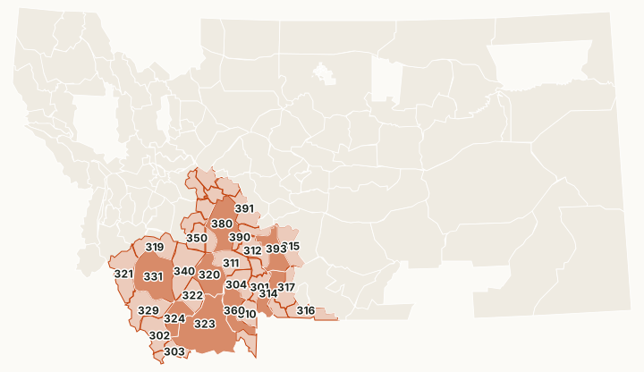
Region 3 is southwest Montana, run from Bozeman: the Gravelly, Madison, Tobacco Root, Pioneer and Bridger ranges, the Big Hole and the upper Yellowstone. It is where the most Montana elk are taken. In 2025 FWP estimated 10,476 elk harvested in Region 3, more than a third of the state's total, and in 2024 FWP counted 46,168 elk hunters here. Public land is about 56% of its districts, with more BLM than in the regions to the north.
Which hunting districts are in Region 3?
All 36 deer and elk districts in Region 3, with FWP's latest harvest estimate and the public land in each. The most elk were taken in HD 323 (748), HD 331 (689) and HD 360 (629). The most public land: HD 316 (98.3%), HD 392 (91.1%) and HD 310 (90.8%).
| District | Name | Square miles | Public land | Block Management acres | Elk harvested, 2025 | Deer harvested, 2025 |
|---|---|---|---|---|---|---|
| HD 301 | Hyalite-Portal | 328 | 85% | 0 | 153 | 315 |
| HD 302 | Tendoys | 599 | 75.8% | 5,137 | 235 | 273 |
| HD 303 | Lima Peaks-Nicholia | 327 | 73.9% | 20,672 | 271 | 75 |
| HD 304 | Spanish Peaks | 439 | 42.3% | 0 | 83 | 185 |
| HD 309 | Gallatin Valley Weapons Restriction Area | 173 | 2.4% | 0 | 37 | 414 |
| HD 310 | Upper Gallatin | 314 | 90.8% | 0 | 58 | 74 |
| HD 311 | Lower Madison | 565 | 13.4% | 2,696 | 198 | 948 |
| HD 312 | West Bridger | 495 | 23% | 1,767 | 281 | 595 |
| HD 313 | Gardiner | 195 | 86.1% | 0 | 282 | 248 |
| HD 314 | Upper Yellowstone West | 542 | 41.8% | 1,675 | 460 | 589 |
| HD 315 | West Slope Crazy Mountains | 580 | 20.4% | 22,678 | 389 | 631 |
| HD 316 | Absaroka | 466 | 98.3% | 0 | 28 | 76 |
| HD 317 | Upper Yellowstone East | 424 | 66.3% | 0 | 379 | 537 |
| HD 318 | Butte-Basin | 270 | 81.5% | 9,593 | 210 | 99 |
| HD 319 | Fleecer-High Rye | 620 | 77.4% | 13,117 | 332 | 166 |
| HD 320 | Tobacco Root Mountains | 803 | 47% | 8,476 | 451 | 1,305 |
| HD 321 | West Big Hole-Mussigbrod | 787 | 62.9% | 6,858 | 544 | 135 |
| HD 322 | Ruby Mountains | 456 | 25.5% | 11,185 | 284 | 688 |
| HD 323 | Gravelly-Centennial | 2,066 | 73.3% | 74,783 | 748 | 671 |
| HD 324 | Blacktail Mountains | 517 | 48.2% | 21,975 | 416 | 573 |
| HD 329 | Big Hole Divide-Horse Prairie | 790 | 66.3% | 17,286 | 432 | 228 |
| HD 331 | Pioneer Mountains-East Big Hole | 1,361 | 81% | 11,857 | 689 | 576 |
| HD 335 | Helena-South | 217 | 54.4% | 6,842 | 227 | 330 |
| HD 339 | Sieben-Sleeping Giant | 294 | 28.6% | 76,938 | 176 | 202 |
| HD 340 | Highlands | 851 | 48.3% | 30,078 | 397 | 604 |
| HD 343 | Helena-North | 246 | 52.8% | 19,689 | 165 | 241 |
| HD 350 | Whitetail-Bull Mountains | 357 | 82.5% | 13,692 | 93 | 183 |
| HD 360 | Madison Range | 678 | 54.6% | 2,693 | 629 | 483 |
| HD 361 | Hebgen-Upper Madison | 224 | 80% | 0 | 79 | 44 |
| HD 370 | Bull Mountains | 185 | 37.1% | 20,180 | 103 | 95 |
| HD 380 | Radersburg | 1,044 | 42.1% | 87,067 | 419 | 723 |
| HD 388 | Tenmile-Prickly Pear Valley | 196 | 8.8% | 692 | 31 | 233 |
| HD 390 | Sixteenmile Creek | 340 | 9.8% | 5,536 | 162 | 233 |
| HD 391 | Dry Creek-Avalanche | 472 | 39.3% | 12,978 | 313 | 677 |
| HD 392 | Avalanche-Gates of the Mountains | 251 | 91.1% | 86 | 94 | 341 |
| HD 393 | East Bridger | 617 | 12.6% | 14,255 | 507 | 598 |
Harvest: FWP Harvest Estimates (elk and deer, 2020 to 2025). Public land and Block Management acres measured by FilledTag inside FWP's district boundaries from Montana Cadastral Public Lands, Montana State Library, published 2026 and FWP Block Management area boundaries (2026).
How many elk and deer are harvested in Region 3?
FWP's region totals, year by year. In 2024, 46,168 elk hunters spent 432,635 days in Region 3.
| Year | Elk harvested | Bulls | Elk hunters | Deer harvested | Mule deer | White-tailed deer | Deer hunters |
|---|---|---|---|---|---|---|---|
| 2025 | 10,476 | 5,468 | not counted | 14,590 | 7,476 | 7,114 | 35,289 |
| 2024 | 11,795 | 5,306 | 46,168 | 15,347 | 7,702 | 7,645 | not counted |
| 2023 | 9,963 | 5,151 | not counted | 14,225 | 7,013 | 7,212 | 33,454 |
| 2022 | 14,541 | 7,224 | 44,539 | 14,578 | 7,102 | 7,475 | not counted |
| 2021 | 12,047 | 5,946 | not counted | 15,050 | 7,191 | 7,859 | 32,811 |
| 2020 | 12,416 | 6,291 | 45,198 | 16,719 | 7,187 | 9,532 | not counted |
How much public land is in Region 3?
| Manager | Acres | Share of the region |
|---|---|---|
| National forest | 4,741,395 | 38.8% |
| BLM | 1,207,309 | 9.9% |
| State trust land | 646,894 | 5.3% |
| FWP land | 131,405 | 1.1% |
| Other public | 67,648 | 0.6% |
| National wildlife refuge | 45,330 | 0.4% |
| Bureau of Reclamation | 16,221 | 0.1% |
| National park (no hunting) | 1,131 | under 0.1% |
Block Management: FWP's 2026 map shows 100 areas in Region 3, about 525,245 acres: 71 where hunters fill in their own permission slip (Type 1) and 29 where the landowner or FWP gives permission (Type 2).
Wildlife management areas in Region 3
FWP manages 11 wildlife management areas open to hunting in Region 3, from Mount Haggin (60,029 acres) down to Lake Helena (431 acres).
- Mount Haggin: 60,029 acres
- Robb-Ledford: 28,236 acres
- Blacktail: 17,964 acres
- Gallatin: 8,653 acres
- Wall Creek: 7,709 acres
- Fleecer Mountain: 7,591 acres
- Canyon Ferry: 5,920 acres
- Dome Mountain: 5,017 acres
- Bear Creek: 3,468 acres
- Canyon Creek: 3,315 acres
- Lake Helena: 431 acres
Get a Montana hunt plan when they open
Hunt plans for Montana are coming. Join the list and you'll hear first. The first 50 hunters in each new state get their plan free.
Until then, the free FilledTag app for iPhone has a map that works in every state, Montana included.
Sources: FWP Harvest Estimates (elk and deer, 2020 to 2025); Montana Cadastral Public Lands, Montana State Library, published 2026; FWP Block Management area boundaries (2026); FWP wildlife management area boundaries. FilledTag is not part of Montana Fish, Wildlife & Parks.
Montana hunting Region 1 Region 2 Region 4 Region 5 Region 6 Region 7