Northwest Montana: FWP Region 1 elk and deer hunting
FWP Region 1, run from Kalispell, has 15 deer and elk hunting districts and is 75.7% public land (Montana Cadastral Public Lands, Montana State Library, published 2026). FWP estimates 1,298 elk and 10,816 deer were harvested in Region 1 in 2025.
Data updated October 2026. Harvest: FWP estimates to 2025. Land: Montana State Library, 2026-10. Block Management: FWP, 2026.
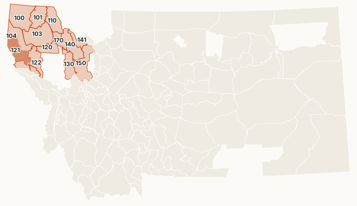
Region 1 is northwest Montana, from Glacier National Park and the Canadian line south to the Clark Fork. It is the most forested region: national forest is about 71% of its deer and elk districts, and there is almost no BLM land. It is white-tailed deer country first. In 2025 FWP estimated 9,646 white-tailed deer were harvested here against 1,170 mule deer. The Flathead Indian Reservation sits inside the region and is not FWP ground; it needs a tribal license.
Which hunting districts are in Region 1?
All 15 deer and elk districts in Region 1, with FWP's latest harvest estimate and the public land in each. The most elk were taken in HD 121 (237), HD 101 (195) and HD 103 (154). The most public land: HD 150 (100%), HD 141 (98%) and HD 140 (93%).
| District | Name | Square miles | Public land | Block Management acres | Elk harvested, 2025 | Deer harvested, 2025 |
|---|---|---|---|---|---|---|
| HD 100 | North Kootenai | 1,407 | 88.9% | 29,524 | 103 | 1,140 |
| HD 101 | Eureka | 806 | 78.9% | 1,306 | 195 | 1,158 |
| HD 103 | South Salish | 1,448 | 51% | 278,736 | 154 | 1,715 |
| HD 104 | Cabinets | 756 | 77.2% | 51,189 | 91 | 533 |
| HD 110 | North Fork | 793 | 85.7% | 10,195 | 40 | 465 |
| HD 120 | Blacktail | 493 | 26.5% | 103,784 | 66 | 694 |
| HD 121 | West Clark Fork | 980 | 82.2% | 7,016 | 237 | 1,155 |
| HD 122 | Thompson River | 716 | 53.8% | 144,701 | 135 | 794 |
| HD 123 | Clark Mountain | 238 | 91.1% | 2,272 | 34 | 213 |
| HD 124 | Arvilla | 129 | 65.6% | 0 | 33 | 212 |
| HD 130 | Swan | 672 | 90% | 0 | 44 | 650 |
| HD 140 | Lower South Fork | 878 | 93% | 0 | 33 | 157 |
| HD 141 | Lower Middle Fork | 339 | 98% | 0 | 15 | 25 |
| HD 150 | Upper South Fork | 1,169 | 100% | 0 | 47 | 44 |
| HD 170 | Flathead River | 362 | 8% | 166 | 67 | 1,772 |
Harvest: FWP Harvest Estimates (elk and deer, 2020 to 2025). Public land and Block Management acres measured by FilledTag inside FWP's district boundaries from Montana Cadastral Public Lands, Montana State Library, published 2026 and FWP Block Management area boundaries (2026).
How many elk and deer are harvested in Region 1?
FWP's region totals, year by year. In 2024, 13,713 elk hunters spent 136,492 days in Region 1.
| Year | Elk harvested | Bulls | Elk hunters | Deer harvested | Mule deer | White-tailed deer | Deer hunters |
|---|---|---|---|---|---|---|---|
| 2025 | 1,298 | 881 | not counted | 10,816 | 1,170 | 9,646 | 23,214 |
| 2024 | 1,301 | 961 | 13,713 | 11,653 | 1,219 | 10,434 | not counted |
| 2023 | 980 | 721 | not counted | 10,302 | 1,197 | 9,105 | 22,301 |
| 2022 | 996 | 757 | 12,393 | 10,072 | 1,080 | 8,992 | not counted |
| 2021 | 889 | 673 | not counted | 10,242 | 995 | 9,247 | 20,846 |
| 2020 | 989 | 656 | 12,210 | 10,389 | 912 | 9,477 | not counted |
How much public land is in Region 1?
| Manager | Acres | Share of the region |
|---|---|---|
| National forest | 5,067,020 | 70.8% |
| State trust land | 317,423 | 4.4% |
| National wildlife refuge | 16,343 | 0.2% |
| FWP land | 16,295 | 0.2% |
| Other public | 12,977 | 0.2% |
| National park (no hunting) | 335 | under 0.1% |
| BLM | 1 | under 0.1% |
Block Management: FWP's 2026 map shows 19 areas in Region 1, about 629,191 acres: 13 where hunters fill in their own permission slip (Type 1) and 6 where the landowner or FWP gives permission (Type 2).
Wildlife management areas in Region 1
FWP manages 13 wildlife management areas open to hunting in Region 1, from Ninepipe (4,147 acres) down to Roundhorn (27 acres).
- Ninepipe: 4,147 acres
- North Swan Valley: 1,886 acres
- Bull River: 1,576 acres
- Ray Kuhns: 1,557 acres
- Mount Silcox: 1,535 acres
- Kootenai Woods Ranch: 1,484 acres
- Kootenai West: 921 acres
- Bad Rock Canyon: 773 acres
- Full Curl: 440 acres
- North Shore: 426 acres
- Pablo: 195 acres
- Kootenai Falls: 172 acres
- Roundhorn: 27 acres
Get a Montana hunt plan when they open
Hunt plans for Montana are coming. Join the list and you'll hear first. The first 50 hunters in each new state get their plan free.
Until then, the free FilledTag app for iPhone has a map that works in every state, Montana included.
Sources: FWP Harvest Estimates (elk and deer, 2020 to 2025); Montana Cadastral Public Lands, Montana State Library, published 2026; FWP Block Management area boundaries (2026); FWP wildlife management area boundaries. FilledTag is not part of Montana Fish, Wildlife & Parks.
Montana hunting Region 2 Region 3 Region 4 Region 5 Region 6 Region 7