West-central Montana: FWP Region 2 elk and deer hunting
FWP Region 2, run from Missoula, has 28 deer and elk hunting districts and is 68% public land (Montana Cadastral Public Lands, Montana State Library, published 2026). FWP estimates 3,598 elk and 9,217 deer were harvested in Region 2 in 2025.
Data updated October 2026. Harvest: FWP estimates to 2025. Land: Montana State Library, 2026-10. Block Management: FWP, 2026.
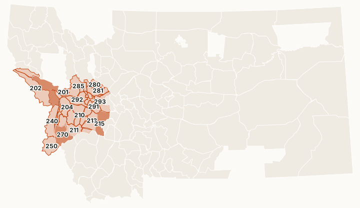
Region 2 is west-central Montana around Missoula: the Bitterroot, Blackfoot, Clark Fork and Flint Creek valleys and the mountains between them. National forest is about 59% of its districts. The region has several archery-only districts, such as HD 260 in the Bitterroot and Clark Fork valleys, and the East Fork Bitterroot (HD 270), where FWP notes that unlimited brow-tined bull permits bring very high hunter numbers.
Which hunting districts are in Region 2?
All 28 deer and elk districts in Region 2, with FWP's latest harvest estimate and the public land in each. The most elk were taken in HD 270 (621), HD 215 (346) and HD 213 (325). The most public land: HD 280 (100%), HD 250 (97%) and HD 202 (94.4%).
| District | Name | Square miles | Public land | Block Management acres | Elk harvested, 2025 | Deer harvested, 2025 |
|---|---|---|---|---|---|---|
| HD 200 | North St. Regis | 237 | 88.9% | 2,363 | 20 | 204 |
| HD 201 | Missoula - Ninemile - North Superior | 1,045 | 76.4% | 6,061 | 274 | 1,025 |
| HD 202 | South Superior | 959 | 94.4% | 4,250 | 79 | 701 |
| HD 204 | North Sapphire | 403 | 62.9% | 7,758 | 113 | 406 |
| HD 210 | John Long Range | 488 | 43.3% | 11,082 | 172 | 295 |
| HD 211 | Upper Rock Creek-Georgetown Lake | 407 | 82.2% | 2,092 | 100 | 103 |
| HD 212 | West Flint Range | 133 | 77.5% | 1,308 | 38 | 126 |
| HD 213 | East Flint Range | 496 | 46.2% | 13,498 | 325 | 337 |
| HD 214 | Mill Creek-Storm Lake | 116 | 54.1% | 0 | 25 | 73 |
| HD 215 | East Deer Lodge | 579 | 49.4% | 21,781 | 346 | 286 |
| HD 216 | West Rock Creek-Quigg Peak | 296 | 89.8% | 1,556 | 44 | 141 |
| HD 217 | Northwest Flint Range | 142 | 29.2% | 13,488 | 105 | 151 |
| HD 240 | West Bitterroot | 671 | 79.8% | 1,357 | 136 | 775 |
| HD 250 | West Fork Bitterroot | 555 | 97% | 0 | 38 | 175 |
| HD 260 | Bitterroot - Clark Fork Archery District | 155 | 7.7% | 2,468 | 33 | 669 |
| HD 261 | East Bitterroot | 214 | 62.2% | 469 | 57 | 183 |
| HD 262 | Bitterroot Farmlands | 125 | 2.1% | 483 | 184 | 368 |
| HD 270 | East Fork Bitterroot | 664 | 84.6% | 2,071 | 621 | 395 |
| HD 280 | North Blackfoot | 305 | 100% | 0 | 17 | 48 |
| HD 281 | Upper Blackfoot | 379 | 74.9% | 46,212 | 77 | 373 |
| HD 282 | Blackfoot-Clearwater WMA | 41 | 86% | 51 | 31 | 104 |
| HD 284 | Lincoln Archery District | 17 | 12.6% | 2,662 | 15 | 27 |
| HD 285 | Monture | 662 | 73.3% | 89,206 | 113 | 1,107 |
| HD 290 | Helmville-Ovando Archery District | 53 | 18% | 0 | 80 | 88 |
| HD 291 | East Garnet Range | 322 | 20.1% | 49,059 | 133 | 110 |
| HD 292 | West Garnet Range | 484 | 48.1% | 91,116 | 121 | 531 |
| HD 293 | South Lincoln-Nevada Creek | 444 | 56.1% | 43,449 | 231 | 242 |
| HD 298 | Ovando-Helmville | 152 | 6.8% | 11,898 | 56 | 108 |
Harvest: FWP Harvest Estimates (elk and deer, 2020 to 2025). Public land and Block Management acres measured by FilledTag inside FWP's district boundaries from Montana Cadastral Public Lands, Montana State Library, published 2026 and FWP Block Management area boundaries (2026).
How many elk and deer are harvested in Region 2?
FWP's region totals, year by year. In 2024, 21,735 elk hunters spent 216,706 days in Region 2.
| Year | Elk harvested | Bulls | Elk hunters | Deer harvested | Mule deer | White-tailed deer | Deer hunters |
|---|---|---|---|---|---|---|---|
| 2025 | 3,598 | 1,912 | not counted | 9,217 | 2,139 | 7,078 | 23,286 |
| 2024 | 3,391 | 1,829 | 21,735 | 9,707 | 2,034 | 7,673 | not counted |
| 2023 | 2,949 | 1,874 | not counted | 9,310 | 1,868 | 7,443 | 22,208 |
| 2022 | 3,460 | 2,160 | 19,479 | 8,883 | 1,662 | 7,221 | not counted |
| 2021 | 3,049 | 1,809 | not counted | 8,325 | 1,589 | 6,736 | 20,231 |
| 2020 | 3,497 | 2,023 | 21,567 | 8,989 | 1,602 | 7,387 | not counted |
How much public land is in Region 2?
| Manager | Acres | Share of the region |
|---|---|---|
| National forest | 3,977,450 | 58.9% |
| State trust land | 260,876 | 3.9% |
| BLM | 192,484 | 2.9% |
| FWP land | 146,863 | 2.2% |
| Other public | 90,012 | 1.3% |
| National wildlife refuge | 7,669 | 0.1% |
| National park (no hunting) | 1,279 | under 0.1% |
Block Management: FWP's 2026 map shows 68 areas in Region 2, about 426,055 acres: 46 where hunters fill in their own permission slip (Type 1) and 22 where the landowner or FWP gives permission (Type 2).
Wildlife management areas in Region 2
FWP manages 14 wildlife management areas open to hunting in Region 2, from Spotted Dog (37,690 acres) down to Mount Jumbo (118 acres).
- Spotted Dog: 37,690 acres
- Fish Creek: 36,101 acres
- Blackfoot-Clearwater: 29,343 acres
- Marshall Creek: 24,798 acres
- Garrity Mountain: 10,833 acres
- Threemile: 6,430 acres
- Warm Springs: 4,180 acres
- Calf Creek: 2,415 acres
- Nevada Lake: 1,523 acres
- Lost Creek: 1,410 acres
- Aunt Molly: 1,183 acres
- Stucky Ridge: 294 acres
- Blue Eyed Nellie: 194 acres
- Mount Jumbo: 118 acres
Get a Montana hunt plan when they open
Hunt plans for Montana are coming. Join the list and you'll hear first. The first 50 hunters in each new state get their plan free.
Until then, the free FilledTag app for iPhone has a map that works in every state, Montana included.
Sources: FWP Harvest Estimates (elk and deer, 2020 to 2025); Montana Cadastral Public Lands, Montana State Library, published 2026; FWP Block Management area boundaries (2026); FWP wildlife management area boundaries. FilledTag is not part of Montana Fish, Wildlife & Parks.
Montana hunting Region 1 Region 3 Region 4 Region 5 Region 6 Region 7