Southeast Montana: FWP Region 7 elk and deer hunting
FWP Region 7, run from Miles City, has 6 deer and elk hunting districts and is 23.5% public land (Montana Cadastral Public Lands, Montana State Library, published 2026). FWP estimates 1,782 elk and 10,624 deer were harvested in Region 7 in 2025.
Data updated October 2026. Harvest: FWP estimates to 2025. Land: Montana State Library, 2026-10. Block Management: FWP, 2026.
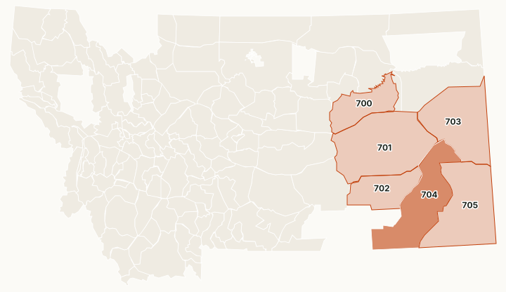
Region 7 is southeast Montana, run from Miles City: pine hills, breaks and prairie from the Yellowstone River to the Wyoming and Dakota lines. It has only 6 deer and elk districts, the largest in the state. About 24% is public land, mostly BLM and state trust land, with national forest in the Ashland and Long Pines country. FWP's 2026 map shows 263 Block Management areas here, about 1.98 million acres, more than any other region.
Which hunting districts are in Region 7?
All 6 deer and elk districts in Region 7, with FWP's latest harvest estimate and the public land in each. The most elk were taken in HD 700 (588), HD 704 (492) and HD 702 (263). The most public land: HD 700 (38%), HD 704 (30.2%) and HD 705 (30.2%).
| District | Name | Square miles | Public land | Block Management acres | Elk harvested, 2025 | Deer harvested, 2025 |
|---|---|---|---|---|---|---|
| HD 700 | Missouri Breaks-Prairie | 2,697 | 38% | 176,864 | 588 | 1,495 |
| HD 701 | Sagebrush Prairie | 7,218 | 18.1% | 699,482 | 1,711 | |
| HD 702 | Yellowstone Pine Hills | 2,761 | 9.7% | 138,211 | 263 | 900 |
| HD 703 | Grassland-Agriculture | 5,458 | 16% | 356,911 | 111 | 1,725 |
| HD 704 | Powder Pine Hills | 5,429 | 30.2% | 142,517 | 492 | 2,421 |
| HD 705 | Prairie/Pines-Juniper Breaks | 6,168 | 30.2% | 396,480 | 145 | 2,261 |
Harvest: FWP Harvest Estimates (elk and deer, 2020 to 2025). Public land and Block Management acres measured by FilledTag inside FWP's district boundaries from Montana Cadastral Public Lands, Montana State Library, published 2026 and FWP Block Management area boundaries (2026).
How many elk and deer are harvested in Region 7?
FWP's region totals, year by year. In 2024, 5,794 elk hunters spent 44,428 days in Region 7.
| Year | Elk harvested | Bulls | Elk hunters | Deer harvested | Mule deer | White-tailed deer | Deer hunters |
|---|---|---|---|---|---|---|---|
| 2025 | 1,782 | 911 | not counted | 10,624 | 7,176 | 3,448 | 18,546 |
| 2024 | 1,941 | 845 | 5,794 | 11,595 | 7,238 | 4,357 | not counted |
| 2023 | 1,543 | 704 | not counted | 12,252 | 7,475 | 4,777 | 19,220 |
| 2022 | 1,425 | 746 | 4,963 | 13,592 | 8,880 | 4,711 | not counted |
| 2021 | 1,479 | 739 | not counted | 16,559 | 11,279 | 5,280 | 22,881 |
| 2020 | 1,666 | 762 | 5,226 | 22,916 | 16,019 | 6,897 | not counted |
How much public land is in Region 7?
| Manager | Acres | Share of the region |
|---|---|---|
| BLM | 2,503,652 | 13.2% |
| State trust land | 1,185,314 | 6.2% |
| National forest | 526,533 | 2.8% |
| National wildlife refuge | 225,445 | 1.2% |
| Other public | 82,663 | 0.4% |
| FWP land | 22,616 | 0.1% |
| Bureau of Reclamation | 2,083 | under 0.1% |
Block Management: FWP's 2026 map shows 263 areas in Region 7, about 1,979,165 acres: 140 where hunters fill in their own permission slip (Type 1) and 123 where the landowner or FWP gives permission (Type 2).
Wildlife management areas in Region 7
FWP manages 4 wildlife management areas open to hunting in Region 7, from Elk Island (1,701 acres) down to Amelia Island (194 acres).
- Elk Island: 1,701 acres
- Isaac Homestead: 1,661 acres
- Seven Sisters: 1,554 acres
- Amelia Island: 194 acres
Get a Montana hunt plan when they open
Hunt plans for Montana are coming. Join the list and you'll hear first. The first 50 hunters in each new state get their plan free.
Until then, the free FilledTag app for iPhone has a map that works in every state, Montana included.
Sources: FWP Harvest Estimates (elk and deer, 2020 to 2025); Montana Cadastral Public Lands, Montana State Library, published 2026; FWP Block Management area boundaries (2026); FWP wildlife management area boundaries. FilledTag is not part of Montana Fish, Wildlife & Parks.
Montana hunting Region 1 Region 2 Region 3 Region 4 Region 5 Region 6