Northeast Montana: FWP Region 6 elk and deer hunting
FWP Region 6, run from Glasgow, has 10 deer and elk hunting districts and is 30.7% public land (Montana Cadastral Public Lands, Montana State Library, published 2026). FWP estimates 775 elk and 8,212 deer were harvested in Region 6 in 2025.
Data updated October 2026. Harvest: FWP estimates to 2025. Land: Montana State Library, 2026-10. Block Management: FWP, 2026.
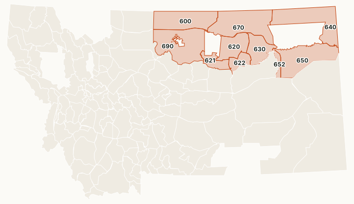
Region 6 is northeast Montana, run from Glasgow: the Missouri River Breaks, the Hi-Line and prairie to the North Dakota line. There is no national forest. BLM land is about 19% of its districts, and the Charles M. Russell National Wildlife Refuge runs along the Missouri; FWP's regulations point hunters to the refuge's restricted-area rules. Mule deer far outnumber whitetails in the harvest: 6,394 to 1,818 in 2025, by FWP's estimate. Block Management covers about 1.48 million acres here.
Which hunting districts are in Region 6?
All 10 deer and elk districts in Region 6, with FWP's latest harvest estimate and the public land in each. The most elk were taken in HD 690 (349), HD 620 (117) and HD 622 (102). The most public land: HD 621 (75.8%), HD 622 (72.1%) and HD 630 (64.8%).
| District | Name | Square miles | Public land | Block Management acres | Elk harvested, 2025 | Deer harvested, 2025 |
|---|---|---|---|---|---|---|
| HD 600 | North Hill-Blaine | 3,061 | 20% | 284,033 | 22 | 1,054 |
| HD 620 | South Phillips | 1,751 | 40.8% | 157,965 | 117 | 439 |
| HD 621 | Upper Missouri Breaks-West | 815 | 75.8% | 69,993 | 93 | 266 |
| HD 622 | Middle Missouri Breaks | 742 | 72.1% | 65,512 | 102 | 98 |
| HD 630 | South Valley | 1,586 | 64.8% | 107,053 | 54 | 799 |
| HD 640 | Northeast Montana | 3,737 | 14.6% | 248,881 | 27 | 1,695 |
| HD 650 | McCone-Richland | 3,532 | 14.3% | 188,277 | 4 | 1,025 |
| HD 652 | McCone-Garfield | 312 | 57.5% | 44,374 | 3 | 60 |
| HD 670 | North Phillips-Valley | 4,123 | 43.6% | 245,063 | 8 | 1,168 |
| HD 690 | South Hill-Blaine-Chouteau | 3,995 | 18.5% | 141,302 | 349 | 1,544 |
Harvest: FWP Harvest Estimates (elk and deer, 2020 to 2025). Public land and Block Management acres measured by FilledTag inside FWP's district boundaries from Montana Cadastral Public Lands, Montana State Library, published 2026 and FWP Block Management area boundaries (2026).
How many elk and deer are harvested in Region 6?
FWP's region totals, year by year. In 2024, 2,939 elk hunters spent 23,955 days in Region 6.
| Year | Elk harvested | Bulls | Elk hunters | Deer harvested | Mule deer | White-tailed deer | Deer hunters |
|---|---|---|---|---|---|---|---|
| 2025 | 775 | 351 | not counted | 8,212 | 6,394 | 1,818 | 15,019 |
| 2024 | 681 | 340 | 2,939 | 10,801 | 7,495 | 3,306 | not counted |
| 2023 | 677 | 326 | not counted | 13,426 | 9,986 | 3,441 | 18,056 |
| 2022 | 714 | 367 | 2,943 | 14,124 | 10,155 | 3,969 | not counted |
| 2021 | 830 | 365 | not counted | 17,163 | 13,821 | 3,342 | 19,226 |
| 2020 | 892 | 372 | 3,245 | 16,711 | 12,388 | 4,323 | not counted |
How much public land is in Region 6?
| Manager | Acres | Share of the region |
|---|---|---|
| BLM | 2,857,431 | 18.9% |
| State trust land | 1,229,620 | 8.1% |
| National wildlife refuge | 484,474 | 3.2% |
| Bureau of Reclamation | 73,598 | 0.5% |
| Other public | 66,237 | 0.4% |
| FWP land | 8,689 | 0.1% |
| National park (no hunting) | 107 | under 0.1% |
Block Management: FWP's 2026 map shows 219 areas in Region 6, about 1,484,844 acres: 197 where hunters fill in their own permission slip (Type 1) and 22 where the landowner or FWP gives permission (Type 2).
Wildlife management areas in Region 6
FWP manages 12 wildlife management areas open to hunting in Region 6, from Lost River (3,706 acres) down to Dodson Creek (54 acres).
- Lost River: 3,706 acres
- Fresno Reservoir: 2,688 acres
- Rookery: 2,293 acres
- Fox Lake: 1,485 acres
- Sleeping Buffalo: 1,315 acres
- Spring Coulee: 1,056 acres
- Dodson Dam: 704 acres
- Vandalia: 404 acres
- Cree Crossing: 398 acres
- Hinsdale: 262 acres
- Fresno Tailwater: 125 acres
- Dodson Creek: 54 acres
Get a Montana hunt plan when they open
Hunt plans for Montana are coming. Join the list and you'll hear first. The first 50 hunters in each new state get their plan free.
Until then, the free FilledTag app for iPhone has a map that works in every state, Montana included.
Sources: FWP Harvest Estimates (elk and deer, 2020 to 2025); Montana Cadastral Public Lands, Montana State Library, published 2026; FWP Block Management area boundaries (2026); FWP wildlife management area boundaries. FilledTag is not part of Montana Fish, Wildlife & Parks.
Montana hunting Region 1 Region 2 Region 3 Region 4 Region 5 Region 7