Bad Rock Canyon Wildlife Management Area: hunting and access
Bad Rock Canyon Wildlife Management Area is 773 acres of land managed by Montana Fish, Wildlife & Parks in Region 1, inside Hunting District 170. FWP's rule for the area: The area is open to recreation from noon May 15 to the start of the youth hunt in late October.
Data updated October 2026. Area facts: FWP's page for Bad Rock Canyon WMA, read 2026-10-17. Boundary: FWP GIS.
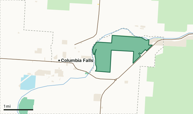
National forestBLMState trust landFWP landOther publicBad Rock Canyon WMAHunting district lineLake or riverHighway
| Size | 773 acres (FWP) |
|---|---|
| FWP region | Region 1, Northwest Montana |
| Hunting districts | HD 170 |
| Rules | Hunting is limited and needs FWP's permission, given on a limited basis through its youth hunt. |
| Camping | Not listed in FWP's area data |
| Hunter access | Refer to current hunting regulations for hunting and weapons restrictions. |
| Elevation | 3013 ft |
| Nearest towns | Columbia Falls (next to it), Hungry Horse (3 mi) and Martin City (4 mi) |
What is Bad Rock Canyon WMA for?
Bad Rock Canyon WMA sits where the Flathead River runs through narrow Bad Rock Canyon, east of Columbia Falls. It is winter range for elk, moose and white-tailed deer and a travel route for bull trout and grizzly bears.
From FWP's Bad Rock Canyon WMA page.
What are the rules on Bad Rock Canyon WMA?
Hunting is limited and needs FWP's permission, given on a limited basis through its youth hunt. The area is open to recreation from noon May 15 to the start of the youth hunt in late October. Motor vehicles only on designated routes, roads and parking areas. No camping, fires, wood cutting or commercial outfitting.
Hunter access, as FWP puts it: Refer to current hunting regulations for hunting and weapons restrictions.
FWP prints a map of the area with its roads and rules: Bad Rock Canyon WMA map (PDF). Hunting follows the regulations of the district the ground is in.
Which hunting districts is Bad Rock Canyon WMA in?
All of Bad Rock Canyon WMA lies in Hunting District 170. Each district's FWP harvest estimate, for the whole district, not the WMA alone:
| District | WMA acres in it | Elk harvested (district) | Deer harvested (district) |
|---|---|---|---|
| HD 170 Flathead River | 773 | 67 (2025) | 1,772 (2025) |
Harvest: FWP Harvest Estimates (elk and deer, 2020 to 2025). WMA acres in each district measured by FilledTag from FWP's boundaries.
How do you get to Bad Rock Canyon WMA?
The WMA is located off U.S. Highway 2 east of Columbia Falls. Designated parking is off River Road or at the BPA powerline corridor.
Highways within 8 miles: US 2, MT 486, MT 206, MT 40 and US 93. Nearest towns: Columbia Falls (next to it), Hungry Horse (3 miles), Martin City (4 miles) and Coram (5 miles).
Questions hunters ask
When is Bad Rock Canyon WMA open?
The area is open to recreation from noon May 15 to the start of the youth hunt in late October, by FWP's rule for the area. Hunting seasons are set by the district's regulations.
Can you camp on Bad Rock Canyon WMA?
FWP does not list camping on Bad Rock Canyon WMA.
Which hunting district is Bad Rock Canyon WMA in?
All of it is in Hunting District 170 (Flathead River).
Request your free Montana hunt plan
The first 50 hunters in Montana get one hunt plan free. Request yours now. We will email you when your plan is ready.
Use the map while you wait for your plan.
Where these facts come from
- Area description, rules, species, facilities and directions: FWP, Bad Rock Canyon WMA.
- Boundary and acres: FWP wildlife management area boundaries. Surrounding public land: Montana Cadastral Public Lands, Montana State Library, published 2026.
- District harvest: FWP Harvest Estimates (elk and deer, 2020 to 2025).
FilledTag is not part of Montana Fish, Wildlife & Parks.