Sandhills Deer Management Unit, Nebraska: deer harvest, public land and walk-in access
Nebraska's Sandhills Deer Management Unit covers 7,806 square miles across Cherry and Hooker counties. 3.4% of it is public land by USGS PAD-US 4.1 and Game and Parks area maps, mostly national forest or grassland, and Game and Parks' 2026-27 OFW map adds 8,433 acres of private walk-in land on 6 tracts. Game and Parks counted 1,812 deer taken across all seasons in 2025: 593 white-tailed bucks and 268 antlerless whitetails, plus 877 mule deer bucks and 74 antlerless mule deer.
Data updated October 2026. Harvest: Game and Parks' 2026 Big Game Recommendations, 2021 to 2025. Seasons: the 2026 Big Game Guide. Land: USGS PAD-US 4.1 and agency area maps. Walk-in: Game and Parks, 2026-27.
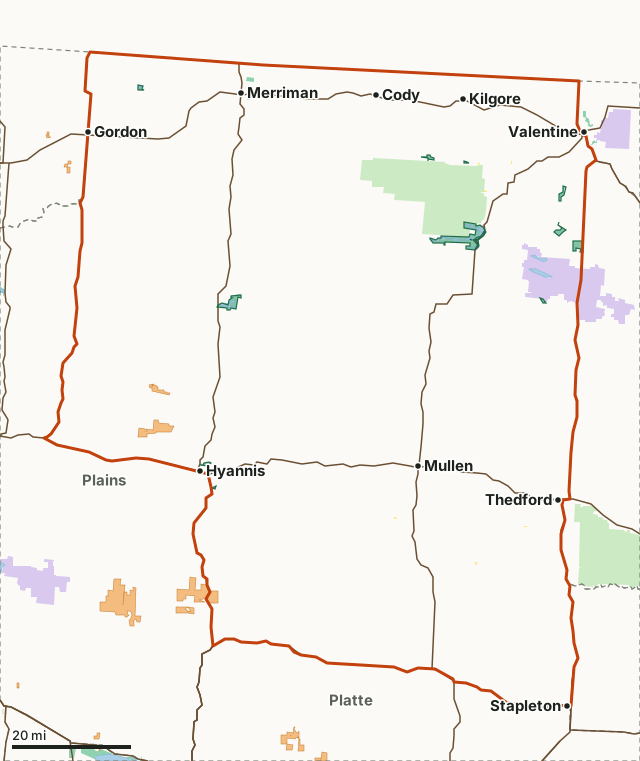
Game and Parks landNational wildlife refuge or WPANational forest or grasslandBureau of ReclamationBLMState park or recreation areaOpen Fields and WatersSandhillsWMANeighboring unitsLakeHighway
| Size | 4,996,094 acres (7,806 square miles) |
|---|---|
| Counties | Cherry, Hooker, Sheridan, McPherson, Grant, Thomas, Logan and Arthur |
| Public land | 3.4% (169,620 acres) |
| Walk-in land (OFW, 2026-27) | 8,433 acres on 6 tracts (0.2% of the unit) |
| Deer harvested, 2025 | 1,812 (1,470 bucks) |
| Unit Buck permits, 2026 | Sandhills: 1,200; Private Land Sandhills: 200; Sandhills WT: 300 |
| WMAs with a page | Merritt Reservoir WMA, Cottonwood/Steverson WMA, Ballards Marsh WMA, Big Alkali Lake WMA and Schlagel Creek WMA |
| Towns in it | Cody, Merriman, Kilgore, Crookston, Mullen and Nenzel |
How many deer are harvested in the Sandhills unit?
Game and Parks counted 1,812 deer across all seasons in 2025, down 22% from 2,323 in 2021. Mule deer were 52.5% of it. Of the white-tailed bucks checked in 2025, 64% were 3 or older.
| Year | Total deer | White-tailed bucks | Antlerless whitetails | Mule deer bucks | Antlerless mule deer | Whitetail bucks 3 and older |
|---|---|---|---|---|---|---|
| 2025 | 1,812 | 593 | 268 | 877 | 74 | 64% |
| 2024 | 1,919 | 678 | 346 | 803 | 92 | 62% |
| 2023 | 1,581 | 628 | 219 | 670 | 64 | 59% |
| 2022 | 2,073 | 753 | 366 | 799 | 155 | 55% |
| 2021 | 2,323 | 892 | 431 | 849 | 171 | 49% |
Source: Game and Parks' 2026 Big Game Recommendations, page 77, the unit's harvest comparisons by year (all seasons and permit types). Buck ages are Game and Parks' estimates from check-station data.
Game and Parks also reports 3 deer depredation complaints in the unit in 2025, and a harvest objective of 1000 mule deer bucks and 750 white-tailed bucks (Game and Parks' 2026 Big Game Recommendations, page 76).
How much public land is in the Sandhills unit?
3.4% of the unit is public land: 169,620 of its 4,996,094 acres, led by national forest or grassland at 114,818 acres. WMAs with a page of their own: Merritt Reservoir WMA, Cottonwood/Steverson WMA, Ballards Marsh WMA, Big Alkali Lake WMA, Schlagel Creek WMA, Chat Canyon WMA, Shell Lake WMA, Frye Lake WMA and Rat and Beaver Lake WMA. Game and Parks' map shows 12 WMAs in the unit in all.
| Manager | Acres | Share of the unit |
|---|---|---|
| National forest or grassland | 114,818 | 2.3% |
| National wildlife refuge or WPA | 39,637 | 0.8% |
| Game and Parks land | 14,168 | 0.3% |
| BLM | 907 | under 0.1% |
| State park or recreation area (not counted as hunting land) | 702 | under 0.1% |
| Bureau of Reclamation | 90 | under 0.1% |
Measured by FilledTag inside Game and Parks' unit boundary from USGS PAD-US 4.1 (fee and designation lands with open or restricted public access) and Game and Parks properties (WMAs, recreation areas, parks) and Game and Parks other public recreation lands; the water of the larger reservoirs is left out.
How much walk-in hunting land is in the Sandhills unit?
Game and Parks' 2026-27 Open Fields and Waters layer maps 8,433 acres on 6 tracts inside the unit, 0.2% of its ground. OFW land is private land Game and Parks leases for walk-in hunting, trapping or fishing; driving on it is prohibited. County totals for the counties the unit touches:
| County | Share of the county in this unit | OFW acres in the county | OFW tracts in the county |
|---|---|---|---|
| Cherry County | 80.8% | 171 | 1 |
| Hooker County | 100% | 0 | 1 |
| Sheridan County | 21.9% | 1,507 | 5 |
| McPherson County | 57.1% | 0 | 0 |
| Grant County | 60.3% | 0 | 0 |
| Thomas County | 51.9% | 0 | 0 |
| Logan County | 34.6% | 0 | 0 |
| Arthur County | 22% | 26,700 | 3 |
Walk-in acres inside the unit measured by FilledTag from Game and Parks Open Fields and Waters, 2026-2027; county acres and tract counts are Game and Parks' own figures for each tract.
When is deer season in the Sandhills unit in 2026?
Archery runs Sept. 1 to Dec. 31, 2026, the November firearm season Nov. 14 to 22 and muzzleloader Dec. 1 to 31, with a late antlerless-only firearm season Jan. 1 to 15, 2027. New for 2026, Unit Buck permits use the Season Choice format: one permit is good in archery, November firearm and muzzleloader seasons with the legal weapon for each. A hunter may hold only one Sandhills permit that allows a mule deer buck. Nonresidents get Sandhills permits through the June draw.
| Unit Buck permit, 2026 | Quota | Bag limit | Sold out in 2025 |
|---|---|---|---|
| Sandhills | 1,200 | 1 AD2 | R - Nov. 11, NR - DRAW |
| Private Land Sandhills | 200 | 1 AD2 | July 29 |
| Sandhills WT | 300 | 1 WT | Nov. 12 |
| Antlerless Only permit, 2026 | Quota | Bag limit | Sold out in 2025 |
|---|---|---|---|
| AO Sandhills | 100 | 1 AO, 1 AOWT | Sept. 27 |
| AO WT Sandhills | 300 | 2 AOWT | DNS |
Source: Game and Parks' 2026 Big Game Guide, page 13 (Unit Buck permits) and page 17 (Antlerless Only). AD is any deer, AD2 any deer except an antlerless mule deer, WT whitetail, AOWT antlerless whitetail.
Special rules for the Sandhills unit
- McKelvie National Forest and Valentine NWR are closed to use of bonus antlerless tags and Season Choice antlerless permits.
Source: Game and Parks' 2026 Big Game Guide, page 19.
Statewide, antlerless mule deer may not be taken on land open to public hunting, except Open Fields and Waters land (Game and Parks' 2026 Big Game Guide, page 19).
How did the Sandhills permits do in 2025?
| Permit, 2025 | Quota, sold, sell-out | Deer taken (MD bucks, MD antlerless, MD total, WT bucks, WT antlerless, WT total) | Success on first deer |
|---|---|---|---|
| Sandhills | 1200, 1200, 11/11/25 | 377, 5, 382, 190, 81, 271 | 50% |
| Sandhills PLO | 200, 200, 7/29/25 | 92, 0, 92, 41, 11, 52 | 66% |
| Sandhills WT | 300, 300, 11/12/25 | 2, 0, 2, 129, 20, 149 | 46% |
| Sandhills AO | 100, 101, 7/27/25 | 1, 22, 23, 1, 18, 19 | 33% |
Source: Game and Parks' 2026 Big Game Recommendations, page 76, 2025 harvest data for the unit. Success is the share of permit holders who took a deer, as Game and Parks reports it.
Is there elk or pronghorn hunting in the Sandhills unit?
Game and Parks' elk unit map overlaps it: elk unit 6, elk unit 9 and elk unit 10. Pronghorn units that overlap it: Cherry, Dismal and Prairie Muzzleloader. Elk permits are all drawn; nonresidents can hunt pronghorn only with archery, landowner or late doe/fawn permits.
Units: Game and Parks elk hunting units; Game and Parks antelope hunting units. Rules: Game and Parks' 2026 Big Game Guide, page 20 to 26.
Which deer units border the Sandhills unit?
Sandhills touches 6 other units. Their public land, walk-in acres and 2025 harvest, for comparison:
| Unit | Public land | OFW acres | Deer harvested, 2025 |
|---|---|---|---|
| Calamus West | 5% | 16,790 | 1,108 |
| Keya Paha | 1.5% | 8,300 | 1,859 |
| Loup West | 0.2% | 5,401 | 1,023 |
| Pine Ridge | 9% | 29,929 | 1,556 |
| Plains | 1.2% | 38,662 | 1,158 |
| Platte | 0.6% | 52,128 | 1,423 |
Questions hunters ask
How much public land is in Nebraska's Sandhills deer unit?
169,620 acres, 3.4% of the unit, by USGS PAD-US 4.1 and Game and Parks area maps; the largest share is national forest or grassland (114,818 acres). Game and Parks' walk-in program adds 8,433 acres of private land open to walk-in hunting in 2026-27.
How many deer were harvested in the Sandhills unit in the latest year on record?
1,812 across all seasons in 2025, by Game and Parks' count: 861 white-tailed deer and 951 mule deer.
How many Unit Buck permits does the Sandhills unit have in 2026?
Sandhills: 1,200 (1 AD2); Private Land Sandhills: 200 (1 AD2); Sandhills WT: 300 (1 WT). Each is a Season Choice permit, good in archery, November firearm and muzzleloader seasons.
Which counties are in the Sandhills unit?
Cherry, Hooker, Sheridan, McPherson, Grant, Thomas, Logan and Arthur. Walk-in land by county is on each county's OFW page where one exists.
Get a Nebraska hunt plan when they open
Hunt plans for Nebraska are coming. Join the list and you'll hear first. The first 50 hunters in each new state get their plan free.
Until then, the free FilledTag app for iPhone has a map that works in every state, Nebraska included.
Where these numbers come from
- Harvest: Game and Parks' 2026 Big Game Recommendations.
- Seasons, permits and rules: Game and Parks' 2026 Big Game Guide.
- Public land: USGS PAD-US 4.1. Walk-in land: Game and Parks Open Fields and Waters, 2026-2027. Unit boundary: Game and Parks deer management units.
- Highways and towns: U.S. Census Bureau TIGER/Line 2024 primary and secondary roads; U.S. Census Bureau 2024 Gazetteer, places.
FilledTag is not part of Nebraska Game and Parks Commission. Numbers are copied from Game and Parks, the USGS and the Census Bureau, or measured from their maps; nothing on this page is estimated by FilledTag.
Nebraska hunting Open Fields and Waters by county Calamus West Keya Paha Loup West Pine Ridge Plains Platte