Nebraska Open Fields and Waters by county: 2026-27 tracts and acres
Game and Parks' 2026-27 Open Fields and Waters map has 326,855 acres on 816 contracts in 74 of Nebraska's 93 counties. Chase County has the most, 46,557 acres. OFW sites are private land open to walk-in hunting, trapping or fishing; driving on them is prohibited.
Data updated October 2026. Walk-in: Game and Parks, 2026-27.
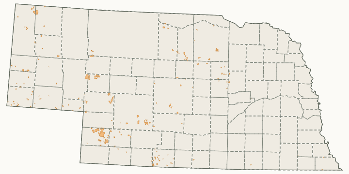
How much OFW land does each county have?
| County | Acres | Contracts | Share of the county | Deer units |
|---|---|---|---|---|
| Chase County | 46,557 | 48 | 8.1% | Frenchman |
| Furnas County | 27,461 | 56 | 6% | Frenchman and Republican |
| Arthur County | 26,700 | 3 | 5.8% | Plains, Platte and Sandhills |
| Lincoln County | 23,134 | 21 | 1.4% | Platte and Frenchman |
| Keith County | 17,843 | 25 | 2.5% | Platte and Plains |
| Sioux County | 13,729 | 18 | 1% | Plains and Pine Ridge |
| Holt County | 13,656 | 11 | 0.9% | Calamus East, Keya Paha, Missouri and Calamus West |
| Kimball County | 12,951 | 32 | 2.1% | Upper Platte |
| Hayes County | 12,676 | 37 | 2.8% | Frenchman |
| Custer County | 11,464 | 15 | 0.7% | Loup West, Buffalo and Platte |
| Cheyenne County | 9,781 | 33 | 1.3% | Upper Platte |
| Perkins County | 8,844 | 35 | 1.6% | Platte and Frenchman |
| Deuel County | 8,679 | 19 | 3.1% | Platte and Upper Platte |
| Hitchcock County | 7,085 | 31 | 1.5% | Frenchman |
| Rock County | 6,733 | 3 | 1% | Calamus West and Keya Paha |
| Wheeler County | 6,318 | 7 | 1.7% | Calamus East and Loup East |
| Banner County | 5,282 | 11 | 1.1% | Upper Platte |
| Richardson County | 4,595 | 31 | 1.3% | Blue Southeast |
| Brown County | 4,041 | 3 | 0.5% | Calamus West and Keya Paha |
| Dawes County | 4,015 | 6 | 0.4% | Pine Ridge and Plains |
| Morrill County | 3,874 | 13 | 0.4% | Plains and Upper Platte |
| Johnson County | 3,219 | 29 | 1.3% | Blue Southeast and Blue Northwest |
| Nemaha County | 3,204 | 28 | 1.2% | Blue Southeast |
| Dawson County | 3,060 | 6 | 0.5% | Buffalo and Platte |
| Garfield County | 2,827 | 2 | 0.8% | Calamus East, Calamus West, Loup West and Loup East |
| Knox County | 2,434 | 24 | 0.3% | Missouri |
| Franklin County | 2,260 | 5 | 0.6% | Republican |
| Harlan County | 2,031 | 13 | 0.6% | Republican |
| Pawnee County | 1,995 | 17 | 0.7% | Blue Southeast |
| Greeley County | 1,961 | 6 | 0.5% | Loup East and Calamus East |
| Gage County | 1,933 | 19 | 0.4% | Blue Southeast and Blue Northwest |
| Cedar County | 1,902 | 18 | 0.4% | Missouri and Elkhorn |
| Boone County | 1,882 | 4 | 0.4% | Loup East, Elkhorn and Calamus East |
| Sheridan County | 1,507 | 5 | 0.1% | Plains, Pine Ridge and Sandhills |
| Dundy County | 1,400 | 10 | 0.2% | Frenchman |
| Thayer County | 1,294 | 8 | 0.4% | Republican, Blue Southeast and Blue Northwest |
| Butler County | 1,153 | 9 | 0.3% | Wahoo |
| Garden County | 1,111 | 5 | 0.1% | Plains, Upper Platte and Platte |
| Jefferson County | 1,089 | 8 | 0.3% | Blue Southeast and Blue Northwest |
| Dixon County | 949 | 13 | 0.3% | Missouri and Elkhorn |
| Saline County | 946 | 4 | 0.3% | Blue Northwest |
| Gosper County | 915 | 7 | 0.3% | Republican, Buffalo and Frenchman |
| Loup County | 867 | 1 | 0.2% | Calamus West and Loup West |
| Webster County | 822 | 6 | 0.2% | Republican |
| Merrick County | 805 | 3 | 0.3% | Loup East, Wahoo and Buffalo |
| Dakota County | 801 | 7 | 0.5% | Elkhorn and Missouri |
| Seward County | 800 | 5 | 0.2% | Blue Northwest and Wahoo |
| Otoe County | 791 | 20 | 0.2% | Blue Southeast and Blue Northwest |
| Antelope County | 779 | 17 | 0.1% | Calamus East, Elkhorn and Missouri |
| Buffalo County | 700 | 3 | 0.1% | Buffalo and Loup East |
| Nance County | 642 | 5 | 0.2% | Loup East |
| Saunders County | 576 | 5 | 0.1% | Wahoo |
| Stanton County | 529 | 4 | 0.2% | Elkhorn |
| Cuming County | 498 | 5 | 0.1% | Elkhorn |
| Frontier County | 376 | 3 | 0.1% | Frenchman, Platte and Buffalo |
| Burt County | 358 | 2 | 0.1% | Elkhorn |
| Sherman County | 328 | 3 | 0.1% | Loup East, Loup West and Buffalo |
| Platte County | 323 | 3 | 0.1% | Loup East, Elkhorn and Wahoo |
| Lancaster County | 320 | 3 | 0.1% | Blue Northwest and Wahoo |
| Polk County | 271 | 2 | 0.1% | Wahoo |
| Pierce County | 268 | 3 | 0.1% | Elkhorn and Missouri |
| Madison County | 260 | 3 | 0.1% | Elkhorn |
| Adams County | 197 | 1 | 0.1% | Republican and Buffalo |
| Nuckolls County | 176 | 2 | under 0.1% | Republican |
| Cherry County | 171 | 1 | under 0.1% | Sandhills, Calamus West and Keya Paha |
| Wayne County | 160 | 1 | 0.1% | Elkhorn |
| Kearney County | 149 | 2 | under 0.1% | Republican and Buffalo |
| Colfax County | 140 | 2 | 0.1% | Elkhorn and Wahoo |
| York County | 78 | 1 | under 0.1% | Wahoo, Blue Northwest and Republican |
| Howard County | 68 | 1 | under 0.1% | Loup East |
| Thurston County | 53 | 1 | under 0.1% | Elkhorn |
| Clay County | 39 | 1 | under 0.1% | Republican and Buffalo |
| Boyd County | 20 | 1 | under 0.1% | Keya Paha and Missouri |
| Hooker County | 0 | 1 | 0% | Sandhills |
Source: Game and Parks Open Fields and Waters, 2026-2027. Counties with a link have a page of their own (three or more tracts and 300 acres, or one tract of 1,500 acres or more).
Questions hunters ask
Which Nebraska county has the most OFW land?
Chase County with 46,557 acres on 48 contracts, then Furnas (27,461), Arthur (26,700) and Lincoln (23,134).
How much OFW land is there in Nebraska?
326,855 acres on 816 contracts in 74 counties on Game and Parks' 2026-27 map; Game and Parks' 2026 Big Game Guide, page 29 puts the program at 471,000 acres.
Get a Nebraska hunt plan when they open
Hunt plans for Nebraska are coming. Join the list and you'll hear first. The first 50 hunters in each new state get their plan free.
Until then, the free FilledTag app for iPhone has a map that works in every state, Nebraska included.
Sources: Game and Parks Open Fields and Waters, 2026-2027; Game and Parks' 2026-27 Public Access Atlas. FilledTag is not part of Nebraska Game and Parks Commission.