Antelope County Open Fields and Waters walk-in hunting: Nebraska 2026-27 tracts, acres and map
Antelope County has 17 Open Fields and Waters contracts on Game and Parks' 2026-27 map, 779 acres in all, 0.1% of the county. That ranks 49th of Nebraska's 93 counties for OFW acres.
Data updated October 2026. Walk-in: Game and Parks' Open Fields and Waters layer for 2026-27. Land: USGS PAD-US 4.1 and agency area maps.
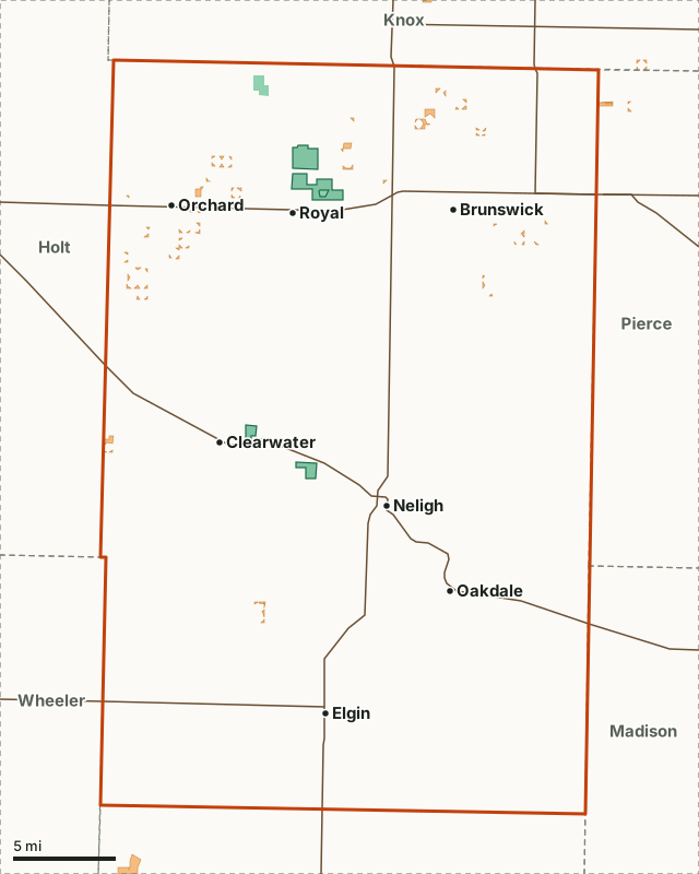
Game and Parks landOpen Fields and WatersAntelope CountyWMALakeHighway
| OFW tracts, 2026-27 | 17 |
|---|---|
| OFW acres | 779 (0.1% of the county) |
| Largest tracts | 192, 94, 70, 61, 60 acres |
| Public land | 2,905 acres (0.5%) |
| Deer units | Calamus East, Elkhorn and Missouri |
| Game and Parks district | NE |
| Towns | Neligh, Elgin, Brunswick, Oakdale, Orchard and Clearwater |
What kinds of Open Fields and Waters land are in Antelope County?
Game and Parks enrolls each site for a purpose, shown on its sign and in the atlas. Antelope County's 17 contracts by program (a contract can carry more than one):
| OFW program | Contracts | Acres |
|---|---|---|
| CRP | 17 | 779 |
| All Hunting Seasons and Trapping | 11 | 634 |
Programs and acres: Game and Parks Open Fields and Waters, 2026-2027.
Where are the biggest walk-in tracts in Antelope County?
The 12 largest sites on Game and Parks' 2026-27 map, each placed by the nearest town:
| Acres | Where | Deer unit | Program | Stubble or other note |
|---|---|---|---|---|
| 192 | 5 mi north of Brunswick | Missouri | CRP | |
| 94 | 5 mi west of Clearwater | Calamus East | CRP | |
| 70 | 1 mi northeast of Orchard | Missouri | CRP | |
| 61 | 2 mi southwest of Orchard | Calamus East | All Hunting Seasons and Trapping | |
| 60 | 4 mi southwest of Orchard | Calamus East | CRP | |
| 51 | 6 mi northwest of Elgin | Calamus East | All Hunting Seasons and Trapping | |
| 47 | 5 mi southwest of Creighton | Missouri | CRP | |
| 38 | 4 mi east of Brunswick | Elkhorn | CRP | |
| 32 | 4 mi south of Brunswick | Elkhorn | CRP | |
| 26 | 3 mi northeast of Orchard | Missouri | CRP | |
| 21 | 3 mi northwest of Royal | Missouri | CRP | |
| 20 | 3 mi northeast of Royal | Missouri | All Hunting Seasons and Trapping |
Tracts: Game and Parks Open Fields and Waters, 2026-2027; towns: U.S. Census Bureau 2024 Gazetteer, places. Use Game and Parks' Public Access Atlas to find each tract's signs and parking.
What public land is in Antelope County?
USGS PAD-US 4.1 and Game and Parks area maps show 2,905 acres of public land in the county, 0.5% of it. The walk-in tracts cover less ground: 779 acres. WMAs with a page: Grove Lake WMA (1,896 acres here) and Red Wing WMA (317 acres here).
| Manager | Acres | Share of the county |
|---|---|---|
| Game and Parks land | 2,905 | 0.5% |
Measured by FilledTag inside the Census county line from USGS PAD-US 4.1 (fee and designation lands with open or restricted public access) and Game and Parks properties (WMAs, recreation areas, parks) and Game and Parks other public recreation lands; the water of the larger reservoirs is left out.
Which deer units cover Antelope County?
Antelope County is split between 3 deer units. A deer hunter on a walk-in tract needs a permit valid in the unit the tract lies in.
| Deer unit | Share of the county | Deer harvested (whole unit) | OFW acres (whole unit) |
|---|---|---|---|
| Calamus East | 43.3% | 628 (2025) | 19,388 |
| Elkhorn | 38.4% | 1,837 (2025) | 4,026 |
| Missouri | 18.3% | 2,242 (2025) | 5,936 |
How does Antelope County compare with the counties around it?
Walk-in acres and public land in the 6 counties that touch Antelope County, most walk-in land first:
| County | OFW acres | OFW tracts | Public land |
|---|---|---|---|
| Holt County | 13,656 | 11 | 0.1% |
| Wheeler County | 6,318 | 7 | 0% |
| Knox County | 2,434 | 24 | 3.9% |
| Boone County | 1,882 | 4 | 0% |
| Pierce County | 268 | 3 | 0% |
| Madison County | 260 | 3 | 0.4% |
Questions hunters ask
How many Open Fields and Waters acres are in Antelope County, Nebraska?
779 acres on 17 contracts on Game and Parks' 2026-27 map, 0.1% of the county.
Can you hunt deer on OFW land in Antelope County?
Yes, in season, with the permit for the deer unit the site is in (Calamus East, Elkhorn and Missouri), unless the site's sign limits it (some close during the November firearm season). Antlerless mule deer may be taken on OFW land, unlike other land open to public hunting.
Is there public land in Antelope County?
2,905 acres, 0.5% of the county, by USGS PAD-US 4.1 and Game and Parks area maps, mostly Game and Parks land. WMAs here: Grove Lake WMA and Red Wing WMA.
Walk-in rules to know
- Walk-in only: driving on enrolled land is prohibited.
- Hunting, trapping and fishing only; no camping, target shooting or scouting before the season.
- Some sites close during the nine-day November firearm deer season or allow only certain uses: read the sign.
- Portable tree stands are not allowed Feb. 1 to Aug. 31.
Source: Game and Parks' 2026-27 Public Access Atlas, page 8.
Get a Nebraska hunt plan when they open
Hunt plans for Nebraska are coming. Join the list and you'll hear first. The first 50 hunters in each new state get their plan free.
Until then, the free FilledTag app for iPhone has a map that works in every state, Nebraska included.
Where these numbers come from
- Walk-in tracts: Game and Parks Open Fields and Waters, 2026-2027.
- Public land: USGS PAD-US 4.1. County line: U.S. Census Bureau 2024 cartographic boundary counties.
- Deer unit harvest: Game and Parks' 2026 Big Game Recommendations.
FilledTag is not part of Nebraska Game and Parks Commission. Tracts change every season; the sign on the tract is the final word.
Nebraska hunting Every county's OFW Calamus East Elkhorn Missouri