Enders Reservoir WMA: hunting, rules and access
Enders Reservoir WMA is 4,599 acres of Game and Parks land, centered about 7 miles southeast of Imperial, in Chase County and the Frenchman deer unit. Atlas note: Portion of area posted as waterfowl refuge.
Data updated October 2026. Game and Parks' 2026-27 Public Access Atlas and property layer; OFW 2026-27.
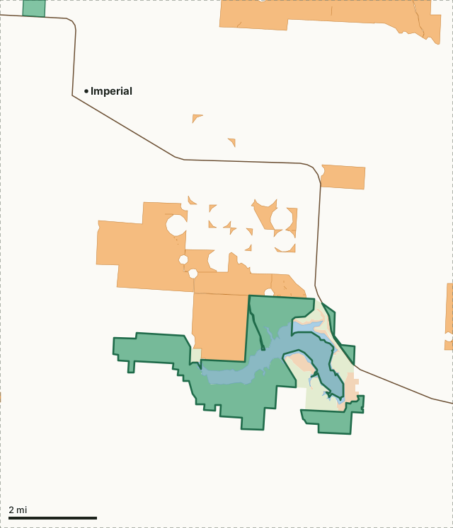
Game and Parks landBureau of ReclamationState park or recreation areaOpen Fields and WatersEnders Reservoir WMAOther WMAsDeer unit lineLakeHighway
| Acres | 4,599 (Game and Parks); 4,359 inside the mapped boundary |
|---|---|
| District and atlas sheet | SW, map sheet 14 |
| County | Chase |
| Deer unit | Frenchman |
| On Game and Parks' records since | 1964 |
What are the rules on Enders Reservoir WMA?
The 2026-27 atlas: Portion of area posted as waterfowl refuge.
Source: Game and Parks' 2026-27 Public Access Atlas, area index (PDF page 119).
Part of the area lies in a state game refuge: Enders Reservoir Waterfowl Refuge (Within the posted boundaries of the refuge, waterfowl may not be hunted or disturbed. Hunting and trapping of other species is allowed during legal seasons in accordance with state and federal regulations. Dogs are allowed when used for lawful hunting or when under control on a leash. Seasonal restrictions apply to boating and motorized vehicle use from October 1 through the last day of February.)
Source: Nebraska game refuge boundaries.
Which deer unit is Enders Reservoir WMA in?
The Frenchman deer unit, 6,013 square miles, with 1,985 deer taken across the whole unit in 2025. The Frenchman unit has special rules in the Big Game Guide (page 19).
Unit Buck permits for the Frenchman unit in 2026: Frenchman 1,000 (1 Buck, sold out R - DRAW, NR - DRAW in 2025) and Frenchman WT 500 (1 WT Buck, sold out July 23 in 2025) (Game and Parks' 2026 Big Game Guide, page 13).
Harvest: Game and Parks' 2026 Big Game Recommendations.
What public and walk-in land is near Enders Reservoir WMA?
Within five miles: 3,328 acres of Game and Parks land, 676 acres of state park or recreation area and 356 acres of Bureau of Reclamation (this area included), and 10,391 acres of OFW walk-in land on 18 tracts. The biggest walk-in tracts reaching into that ring: 19,204 acres 4.1 miles north (All Hunting Seasons and Trapping), 4,485 acres 2.5 miles north (Small Grain Stubble Management), 2,827 acres 4.5 miles east (All Hunting Seasons and Trapping) and 2,344 acres 3.3 miles east (CRP).
Measured by FilledTag from USGS PAD-US 4.1 and Game and Parks Open Fields and Waters, 2026-2027. County walk-in totals: Chase County.
How do you get to Enders Reservoir WMA?
Highways within five miles, longest stretch first: US 6.
| Town | Miles from the boundary | Direction from the area |
|---|---|---|
| Imperial | 6 | northwest |
| Wauneta | 7 | east |
| Hamlet | 15 | east |
| Lamar | 21 | northwest |
| Palisade | 22 | east |
Questions hunters ask
Are there special rules on Enders Reservoir WMA?
Yes. The 2026-27 atlas says: Portion of area posted as waterfowl refuge.
Where is Enders Reservoir WMA?
Its middle is about 7 miles southeast of Imperial, in Chase County and the Frenchman deer unit.
How big is Enders Reservoir WMA?
4,599 acres by Game and Parks' count; 4,359 acres inside the boundary on Game and Parks' map, in 3 pieces.
Get a Nebraska hunt plan when they open
Hunt plans for Nebraska are coming. Join the list and you'll hear first. The first 50 hunters in each new state get their plan free.
Until then, the free FilledTag app for iPhone has a map that works in every state, Nebraska included.
Sources: Game and Parks' 2026-27 Public Access Atlas; Game and Parks properties (WMAs, recreation areas, parks); USGS PAD-US 4.1; Game and Parks Open Fields and Waters, 2026-2027; Game and Parks' 2026 Big Game Recommendations. General WMA rules: all WMAs. FilledTag is not part of Nebraska Game and Parks Commission.