Myrtle E. Hall WMA: hunting, rules and access
Myrtle E. Hall WMA is 1,960 acres of Game and Parks land, centered about 12 miles west of Taylor, in Loup and Custer counties and the Loup West deer unit. Atlas note: In two tracts.
Data updated October 2026. Game and Parks' 2026-27 Public Access Atlas and property layer; OFW 2026-27.
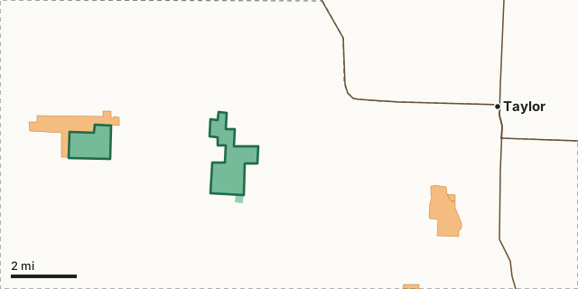
Game and Parks landOpen Fields and WatersMyrtle E. Hall WMAOther WMAsDeer unit lineLakeHighway
| Acres | 1,960 (Game and Parks); 1,950 inside the mapped boundary |
|---|---|
| District and atlas sheet | NE, map sheet 23 |
| County | Loup and Custer |
| Deer unit | Loup West |
| On Game and Parks' records since | 2004 |
What are the rules on Myrtle E. Hall WMA?
The 2026-27 atlas: In two tracts.
Source: Game and Parks' 2026-27 Public Access Atlas, area index (PDF page 124).
Which deer unit is Myrtle E. Hall WMA in?
The Loup West deer unit, 2,607 square miles, with 1,023 deer taken across the whole unit in 2025. No antlerless mule deer here.
Unit Buck permits for the Loup West unit in 2026: Loup West 700 (1 AD2, sold out R - Oct. 11, NR - DRAW in 2025) and Loup West WT 600 (1 WT, sold out Nov. 14 in 2025) (Game and Parks' 2026 Big Game Guide, page 13).
Harvest: Game and Parks' 2026 Big Game Recommendations.
What public and walk-in land is near Myrtle E. Hall WMA?
Within five miles: 1,992 acres of Game and Parks land (this area included), and 861 acres of OFW walk-in land on 1 tract. The biggest walk-in tracts reaching into that ring: 867 acres next to it on the west side (All Hunting Seasons and Trapping (Closure during nine-day rifle deer season in November)). Nearest WMAs: Milburn Dam WMA (6.3 mi) and Calamus Reservoir WMA (14.9 mi).
Measured by FilledTag from USGS PAD-US 4.1 and Game and Parks Open Fields and Waters, 2026-2027. County walk-in totals: Custer County.
How do you get to Myrtle E. Hall WMA?
Highways within five miles, longest stretch first: N-91.
| Town | Miles from the boundary | Direction from the area |
|---|---|---|
| Taylor | 7 | east |
| Sargent | 10 | southeast |
| Anselmo | 15 | southwest |
| Brewster | 18 | northwest |
| Comstock | 19 | southeast |
Questions hunters ask
Are there special rules on Myrtle E. Hall WMA?
Yes. The 2026-27 atlas says: In two tracts.
Where is Myrtle E. Hall WMA?
Its middle is about 12 miles west of Taylor, in Loup and Custer counties and the Loup West deer unit.
How big is Myrtle E. Hall WMA?
1,960 acres by Game and Parks' count; 1,950 acres inside the boundary on Game and Parks' map, in 2 pieces.
Get a Nebraska hunt plan when they open
Hunt plans for Nebraska are coming. Join the list and you'll hear first. The first 50 hunters in each new state get their plan free.
Until then, the free FilledTag app for iPhone has a map that works in every state, Nebraska included.
Sources: Game and Parks' 2026-27 Public Access Atlas; Game and Parks properties (WMAs, recreation areas, parks); USGS PAD-US 4.1; Game and Parks Open Fields and Waters, 2026-2027; Game and Parks' 2026 Big Game Recommendations. General WMA rules: all WMAs. FilledTag is not part of Nebraska Game and Parks Commission.