Dix Wildlife Management Area: deer hunting, parking and rules in Zone 30
Dix Wildlife Management Area is 5,229 acres of New Jersey Fish and Wildlife land in Fairfield (Cumberland County), in Deer Management Zone 30. Hunters took 302 deer in Zone 30 in 2025-26, and the zone follows the Low regulation set for 2026-27. NJFW maps 20 roadside pull-offs, 5 unpaved parking lots, 2 metal gates and 1 fishing access point on the property.
Data updated October 2026. Sources are listed at the foot of the page.
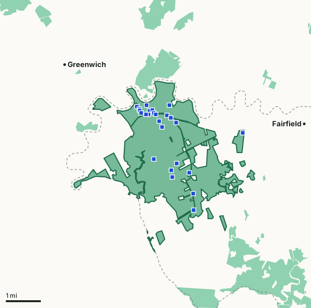
Fish and Wildlife land (WMAs)Dix WMAZone lineParkingHighway
| Size | 5,229 acres (NJDEP), in 19 pieces |
|---|---|
| Municipality | Fairfield |
| County | Cumberland County |
| Deer Management Zone | Zone 30 |
| 2026-27 rules in Zone 30 | Low regulation set |
| Parking (NJFW) | 20 roadside pull-offs and 5 unpaved parking lots |
| NJFW public deer land list | Listed: no extra access permit needed |
| Deer taken in Zone 30, 2025-26 | 302 |
| Nearest town centers | Greenwich (under a mile), Fairfield (2 mi) and Lawrence (4 mi) |
What has NJFW built on Dix WMA?
NJFW's points of interest layer shows 20 roadside pull-offs, 5 unpaved parking lots, 2 metal gates and 1 fishing access point.
| What | Latitude | Longitude |
|---|---|---|
| Unpaved parking lot | 39.37962 | -75.31124 |
| Unpaved parking lot | 39.37957 | -75.32358 |
| Roadside pull-off | 39.37898 | -75.32866 |
| Roadside pull-off | 39.37788 | -75.32747 |
| Roadside pull-off | 39.37763 | -75.32040 |
| Roadside pull-off | 39.37731 | -75.32700 |
| Roadside pull-off | 39.37709 | -75.32194 |
| Roadside pull-off | 39.37647 | -75.31951 |
| Roadside pull-off | 39.37634 | -75.32619 |
| Roadside pull-off | 39.37583 | -75.32360 |
| Unpaved parking lot | 39.37581 | -75.31849 |
| Roadside pull-off | 39.37578 | -75.32227 |
The first 12 of 28 points.
What other hunting areas cover Dix WMA?
NJFW stocks pheasants on its 910-acre Dix pheasant stocking area; hunters need the pheasant and quail stamp to hunt them. For spring turkey the WMA lies in Turkey Hunting Area 21 in NJFW's South region. For ducks and geese it is in the South waterfowl zone.
How many deer are taken around Dix WMA?
NJFW counts deer by zone. Zone 30 gave 302 deer in 2025-26: 164 to bowhunters, 32 in the six-day firearm season, 31 in the permit shotgun season and 64 in the permit muzzleloader season.
| Zone | WMA acres in it | 2025-26 | 2024-25 | 2023-24 | 2022-23 |
|---|---|---|---|---|---|
| Zone 30 | 5,227 | 302 | 310 | 231 | 293 |
| County | 2021-22 | 2022-23 | 2023-24 | 2024-25 | 2025-26 |
|---|---|---|---|---|---|
| Cumberland County | 2,609 | 1,943 | 1,669 | 2,030 | 1,795 |
What rules apply on Dix WMA?
Deer seasons follow Zone 30's Low regulation set; its fall bow season runs October 3 to 30, 2026. An antlered deer in Zone 30 needs 3 points on one side. WMAs close from 9 p.m. to 5 a.m. except to hunters, anglers and trappers.
How do you get to Dix WMA?
Highways within five miles: NJ 49. Distances to the nearest town centers: Greenwich under a mile, Fairfield 2 miles, Lawrence 4 miles and Stow Creek 5 miles. Other WMAs nearby: Cohansey River (3 miles), New Sweden (4 miles), Clarks Pond (6 miles). NJFW publishes a map of Dix WMA.
Questions hunters ask
Can you hunt deer on Dix WMA?
Yes. NJFW's 2026 Digest lists Dix WMA among public deer hunting lands that need no extra access permit. (NJFW Public Hunting Land for Deer (2026 Digest); NJDEP WMA Restrictions in New Jersey)
What deer zone is Dix WMA in?
Zone 30. Hunters took 302 deer in Zone 30 in 2025-26 and 310 in 2024-25 (NJFW 2025-26 New Jersey Total Deer Harvest).
Where do you park for Dix WMA?
NJFW maps 20 roadside pull-offs and 5 unpaved parking lots, listed with coordinates on this page (NJ Fish and Wildlife points of interest (parking, gates, ranges, boat ramps)). Vehicles must stay on established roads and parking areas.
How many deer are taken in Cumberland County?
Cumberland County: 1,795 deer in 2025-26, 2,030 in 2024-25 and 2,609 in 2021-22 (NJFW White-tailed Deer Harvest by County, 2021-22 to 2025-26).
Get a New Jersey hunt plan when they open
Hunt plans for New Jersey are coming. Join the list and you'll hear first. The first 50 hunters in each new state get their plan free.
Until then, the free FilledTag app for iPhone has a map that works in every state, New Jersey included.
Sources: NJDEP open space, NJFW points of interest and WMA restrictions layers; NJFW harvest tables, county harvest, 2026-27 seasons, public deer land list and WMA rules; PAD-US; Census. FilledTag is not part of NJ Fish and Wildlife.