Capital District Wildlife Management Area: hunting, parking and access
Capital District Wildlife Management Area is 6,355 acres (DEC) managed by DEC in the towns of Stephentown and Berlin, Rensselaer County, in WMU 4L (Southern Zone). DEC lists 14 parking areas with coordinates.
Data updated October 2026. Area facts: DEC's page for Capital District WMA, read 2026-10-18. Boundary: DEC GIS.
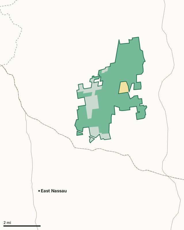
DEC landState parkCapital District WMAWMU lineHighway
| Size | 6,355 acres (DEC) |
|---|---|
| Location (DEC) | Towns of Stephentown and Berlin, Rensselaer County |
| WMU | WMU 4L |
| Zone | Southern Zone |
| DEC region | Region 4 |
| Open | Year-round |
| Fee | Free |
| Parking areas (DEC) | 14 |
| Activities DEC lists | Hiking, Hunting, Trapping, Freshwater Fishing and Watchable Wildlife |
| Nearest towns | East Nassau (4 mi), Averill Park (5 mi) and Poestenkill (7 mi) |
Where do you park at Capital District WMA?
DEC lists 14 parking areas for Capital District WMA:
| DEC's description | Latitude, longitude |
|---|---|
| North intersection of Jiggs/Miller Roads by kiosk | 42.64730, -73.41020 |
| Dingman Road | 42.62450, -73.43130 |
| Miller Road, east side of lake | 42.61830, -73.40780 |
| Intersection of Jiggs/Miller Roads | 42.63010, -73.40920 |
| Miller Road, north end | 42.65100, -73.40680 |
| Dynamite Shack Road | 42.64620, -73.39370 |
| Parking area for escarpment trail | 42.64100, -73.39410 |
| Dynamite Shack Road | 42.63400, -73.39790 |
| Jiggs Hwy | 42.64410, -73.41260 |
| By bridge in center of WMA parking area | 42.62250, -73.41030 |
| Black River Road | 42.60510, -73.40750 |
| Game Refuge Road | 42.60470, -73.42110 |
| Pesticide Shack Road | 42.62480, -73.41350 |
| Game Refuge Road | 42.61380, -73.42880 |
From DEC's page for Capital District WMA.
What can you hunt on Capital District WMA, and when?
DEC's map of hunting on DEC-managed lands marks the area open to hunting. DEC lists these activities for the area: hiking, hunting, trapping, freshwater fishing and watchable wildlife. Hunting on a WMA follows the seasons of the WMU the ground is in. In WMU 4L, the 2026 regular firearms deer season runs November 21 to December 13.
| WMU | WMA acres in it | Deer harvested (whole WMU) | Adult bucks | Bears (whole WMU) |
|---|---|---|---|---|
| WMU 4L | 6,754 | 581 (2025) | 390 | 12 (2025) |
Harvest: DEC 2025 Deer Harvest Summary; DEC 2025 Bear Harvest Summary. Seasons: DEC, 2026 big game hunting seasons in October.
DEC's plans for the area: a Habitat Management Plan approved October 2017.
What DEC says about each activity here
- Watchable Wildlife. "Deer, turkeys, squirrels, and a host of songbirds frequent the area."
From DEC's page for Capital District WMA.
How do you get to Capital District WMA?
Highways within five miles: NY 22, NY 43 and NY 66. Nearest towns: East Nassau (4 miles), Averill Park (5 miles), Poestenkill (7 miles) and West Sand Lake (7 miles). State land nearby, as DEC names it: Berlin State Forest, Cherry Plain State Park, Grafton Lakes State Park and Taconic Ridge State Forest.
Which other WMAs are near Capital District?
| WMA | Miles away (straight line) | WMU | Acres |
|---|---|---|---|
| Coeymans Creek WMA | 20 | 4B | 360 |
| Louise E. Keir WMA | 24 | 4B | 187 |
| Charles Flood at the Empire Brickyard WMA | 26 | 4T | 591 |
| Stockport WMA | 28 | 4T | 357 |
| Black Creek Marsh WMA | 28 | 4B | 450 |
Questions hunters ask
Can you hunt on Capital District WMA?
Yes. DEC's map of hunting on DEC-managed lands marks it open to hunting. Capital District WMA lies in WMU 4L, and seasons follow the WMU's: in 2026 the regular firearms deer season there runs November 21 to December 13.
Where do you park at Capital District WMA?
DEC lists 14 parking areas: North intersection of Jiggs/Miller Roads by kiosk (42.6473, -73.4102), Dingman Road (42.6245, -73.4313) and Miller Road, east side of lake (42.6183, -73.4078), and more in the table on this page.
What WMU is Capital District WMA in?
All of Capital District WMA is in WMU 4L. DEC estimates 581 deer were taken in the whole WMU in 2025.
What is the nearest town to Capital District WMA?
East Nassau, about 4 miles away, by the Census map of places. Averill Park is 5 miles away.
How big is Capital District WMA?
DEC gives 6,355 acres.
Get a New York hunt plan when they open
Hunt plans for New York are coming. Join the list and you'll hear first. The first 50 hunters in each new state get their plan free.
Until then, the free FilledTag app for iPhone has a map that works in every state, New York included.
Where these facts come from
- Area facts, habitat, parking and plans: DEC, Capital District WMA.
- Boundary: DEC Wildlife Management Areas. Public land around it: USGS Protected Areas Database of the United States (PAD-US 4.1). Highways and towns: U.S. Census Bureau TIGER/Line 2024 primary and secondary roads; U.S. Census Bureau 2024 Gazetteer, places.
- WMU harvest: DEC 2025 Deer Harvest Summary; DEC 2025 Bear Harvest Summary. Seasons: DEC, 2026-27 early big game hunting seasons in September; DEC, 2026 big game hunting seasons in October.
FilledTag is not part of the New York State Department of Environmental Conservation.